- Home
- :
- All Communities
- :
- Products
- :
- ArcGIS Pro
- :
- ArcGIS Pro Questions
- :
- Re: Ortho Mapping - errors when creating workspace
- Subscribe to RSS Feed
- Mark Topic as New
- Mark Topic as Read
- Float this Topic for Current User
- Bookmark
- Subscribe
- Mute
- Printer Friendly Page
Ortho Mapping - errors when creating workspace
- Mark as New
- Bookmark
- Subscribe
- Mute
- Subscribe to RSS Feed
- Permalink
Hi all.
Am having my first play with the 'Ortho Mapping' within ArcGIS Pro 1.4. I have some UAV photos captured using a Phantom 4.
I clicked new workspace, entered a name etc, then selected the folder where the photos were located. It successfully detected the geolocation data within the imagery and the spatial reference. I didn't change any parameters, just left everything as default, then I clicked next. It began to create the workspace and a log page appears.
However, here something goes wrong - it begins to spit out errors, looks like they are repeated once for each photo. I have pasted below the error messages. I'd be interested to know if anyone else has experienced this or knows what is happening here and how to fix whatever's going wrong.
Cheers,
-Paul
Queued...
Building image collection...
Start Time: Saturday, 25 March 2017 5:31:24 PM
2017-03-25T17:31:28.826: Loading raster datasets
2017-03-25T17:31:28.972: Completed crawling 573 data source items. Added 573 mosaic dataset items.
2017-03-25T17:31:28.978: Synchronizing crawled data source items
2017-03-25T17:31:29.021: Synchronizing items associated with raster type instance 'UAV/UAS' [ID: 1].
2017-03-25T17:31:29.043: Distributing mosaic dataset operation across 2 parallel instances on the specified host: [LAPTOP-8A254KAB].
2017-03-25T17:31:38.992: Error: 8004206c: Failures reported while processing specified command item. [1]
2017-03-25T17:31:39.002: Error: 80042019: Chained Error ID: 0X80042019
2017-03-25T17:31:39.010: Error: 80042019: Could not build mosaic dataset item. [ID: 1, URI: 'C:\Oskat\photos\DJI_0397.JPG']
2017-03-25T17:31:39.019: Error: 8004103f: Creation of frame camera model failed.
2017-03-25T17:31:39.039: Error: 8004206c: Failures reported while processing specified command item. [2]
2017-03-25T17:31:39.050: Error: 80042019: Chained Error ID: 0X80042019
2017-03-25T17:31:39.059: Error: 80042019: Could not build mosaic dataset item. [ID: 2, URI: 'C:\Oskat\photos\DJI_0398.JPG']
2017-03-25T17:31:39.067: Error: 8004103f: Creation of frame camera model failed.
etc, etc until the end:
2017-03-25T17:33:24.335: Error: 8004206c: Failures reported while processing specified command item. [200]
2017-03-25T17:33:24.345: Error: 80042019: Chained Error ID: 0X80042019
2017-03-25T17:33:24.357: Error: 80042019: Could not build mosaic dataset item. [ID: 200, URI: 'C:\Oskat\photos\DJI_0596.JPG']
2017-03-25T17:33:24.363: Error: 8004103f: Creation of frame camera model failed.
2017-03-25T17:33:24.558: Error: 8004205e: 573 mosaic dataset items could not be built.
2017-03-25T17:33:24.706: Removing invalid mosaic dataset items
2017-03-25T17:33:24.999: Removing unreferenced raster type and overview instances
2017-03-25T17:33:25.011: Removed 573 mosaic dataset items and 1 unreferenced raster type instances.
2017-03-25T17:33:25.270: Removing broken mosaic dataset items.
2017-03-25T17:33:25.499: Removed 0 mosaic dataset items and 0 unreferenced raster type instances.
2017-03-25T17:33:25.685: Completed synchronization: 573 items selected, 0 items synchronized.
ERROR 999999: Error executing function.
Failed to execute (AddRastersToMosaicDataset).
Failed at Saturday, 25 March 2017 5:33:30 PM (Elapsed Time: 2 minutes 5 seconds)
- Mark as New
- Bookmark
- Subscribe
- Mute
- Subscribe to RSS Feed
- Permalink
I am getting the same errors reported by Paul at the start of this thread, however my altitudes are coming in positive. Any other ideas why this might be occurring? I am using ArcGIS Pro 2.2.4, and ArcGIS 10.6.1.
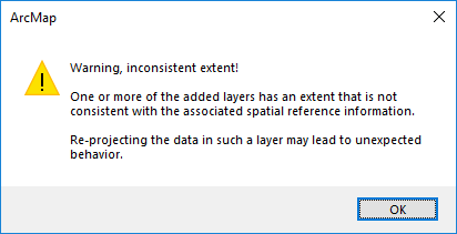
I notice in ArcCatalog that there is no spatial reference associated with my images. I understand how this would be a problem. However when I apply the correct coordinate system, either projected or geographic, ArcMap still throws this error:
- Mark as New
- Bookmark
- Subscribe
- Mute
- Subscribe to RSS Feed
- Permalink
When you say
However when I apply the correct coordinate system, either projected or geographic
That suggests that neither of ones you think it is in applies either, assuming you used the Define Project tool.
It could be that your images don't have a reference system at all.
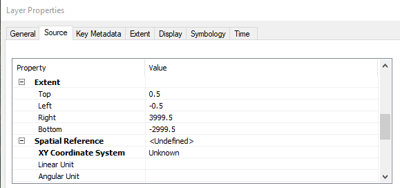
When you add that layer to an empty map/dataframe (no basemaps either), and select the layer in the TOC and examine the layer properties, what is reported for the 'extent' values?
- Mark as New
- Bookmark
- Subscribe
- Mute
- Subscribe to RSS Feed
- Permalink
Yeah so the extents is reporting this, regardless of whether I apply a spatial reference or not. So the images don't have a native coordinate system it seems, and you're not able to trick it into thinking what it is.
Strangely, I have imagery from a different sensor, but same manufacturer, and the EXIF is exactly the same. Yet that imagery will run through the ortho mapping process without any problems.
- Mark as New
- Bookmark
- Subscribe
- Mute
- Subscribe to RSS Feed
- Permalink
You have to georeferenced those images to give them coordinates, they are just 'pictures' in their current form.
- Mark as New
- Bookmark
- Subscribe
- Mute
- Subscribe to RSS Feed
- Permalink
Yes I understand they are just pictures. It is UAV data captured from a flight plan, all done in GPS mode. The images aren't orthorectified. They have a central lat/lon in the EXIF. This is why I am using the imagery & orthomapping tools.
- Mark as New
- Bookmark
- Subscribe
- Mute
- Subscribe to RSS Feed
- Permalink
Hi,
There has been an bug (https://devtopia.esri.com/ArcGISPro/RasterXI/issues/3163) for this issue. It will be fixed in Pro 2.4.
Thanks,
Mingzhen
- Mark as New
- Bookmark
- Subscribe
- Mute
- Subscribe to RSS Feed
- Permalink
Thanks for that. Whats the work-around in the meantime? I still need to process these images today and i have no way of doing it. Do i need to install a previous version of ArcGIS Pro? It worked fine before i upgraded to 2.3.1 last week.
Thanks.
- Mark as New
- Bookmark
- Subscribe
- Mute
- Subscribe to RSS Feed
- Permalink
This does not seem to be fixed in 2.4.
- Mark as New
- Bookmark
- Subscribe
- Mute
- Subscribe to RSS Feed
- Permalink
It looks like this is the bug: BUG-000119757: Failed to create the Ortho Mapping Workspace using i.. which is still open.
If this issue is affecting you, please go to that link and click the Subscribe button:
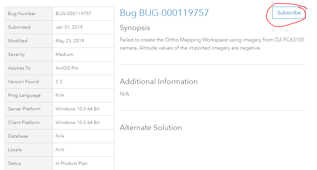
not only will this send you notifications when the Status is updated, it will increment the count of affected users which helps to prioritize a fix.
Thank you.
- Mark as New
- Bookmark
- Subscribe
- Mute
- Subscribe to RSS Feed
- Permalink
Just my 2 cents after my troubles:
VIA ESRI:
I did want to provide you with the workflow to get around the Altitude Too Low error we saw in Pro, however, we will still run into the above mentioned defect due to the camera type. To get past the Altitude Issue:
- Open an ArcGIS Pro Project
- Imagery > Workspace > New Workspace
- Define Your Name, Description and Type
- Next
- Add Images > Click Set Elevation Source in Lower Right Corner of Ortho Mapping Pane
- Elevation Source Dropdown
- Select Constant Elevation
- Set your elevation value (roughly between 50 and 60 m)
- This will adjust the images accordingly
- Elevation Source Dropdown
I apologize for the inconvenience with this issue. I did want to include the orthomapping workflow for ArcMap for reference in case that is something you would want to look at, if not though I understand. That resource can be found here:
- https://desktop.arcgis.com/en/arcmap/latest/manage-data/raster-and-images/ortho-mapping-overview.htm
A bug was logged and fixed in 2.4 when it arrives.
- « Previous
- Next »
- « Previous
- Next »