- Home
- :
- All Communities
- :
- Products
- :
- ArcGIS Pro
- :
- ArcGIS Pro Questions
- :
- Need USNG Grid in Collar
- Subscribe to RSS Feed
- Mark Topic as New
- Mark Topic as Read
- Float this Topic for Current User
- Bookmark
- Subscribe
- Mute
- Printer Friendly Page
- Mark as New
- Bookmark
- Subscribe
- Mute
- Subscribe to RSS Feed
- Permalink
How does one add a USNG Grid as a collar surround? What I need is UTM on the top and left collar, and USNG on the bottom and right. The make grids and grat tool is not the solution here, as we're making several dozen maps per hour all with different extents, and the need for UTM on one side and USNG on the other is an absolute must.
Solved! Go to Solution.
Accepted Solutions
- Mark as New
- Bookmark
- Subscribe
- Mute
- Subscribe to RSS Feed
- Permalink
Hi Thomas,
You should be able to do this using Pro. You'll be adding two separate grids and defining label/tick visibility for each grid.
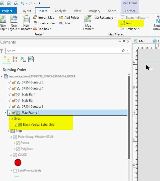
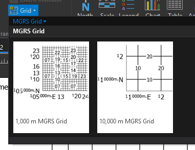
Assuming that your maps are in either the NAD83 or WGS84 datums you should be able to use the MGRS grids provided in the Grid Gallery for the USNG part.
Once you've added the grid you will want to define label/tick visibility.
1. Open the properties for the grid
2. Go to the Options tab & Expand the Edges and Corners group
3. Toggle on both check boxes
Here you'll see the edges and corners of your map frame defined. For example, the "top" is edge 1. The bottom right corner is corner 3.
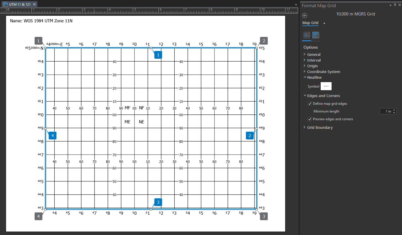
Once the edges and corners are defined it is time to define label\tick visibility.
4. Switch to the Components tab in the Format Map Grid pane.
5. Select the Corner Labels component
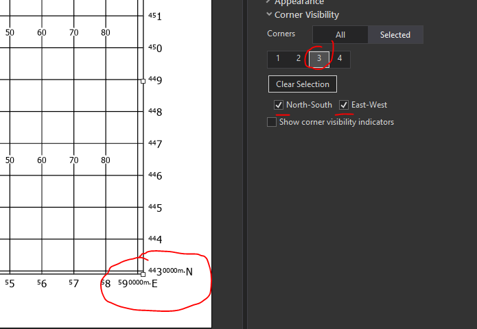
6. Contract all the groups except for Corner Visibility to make the UI easier to work with
7. Click the Selected button to work with individual corners
8. Toggle on the Show corner visibility indicators (I tend to forget which corner is which)
9. Select corner 1 and toggle off the label pairs
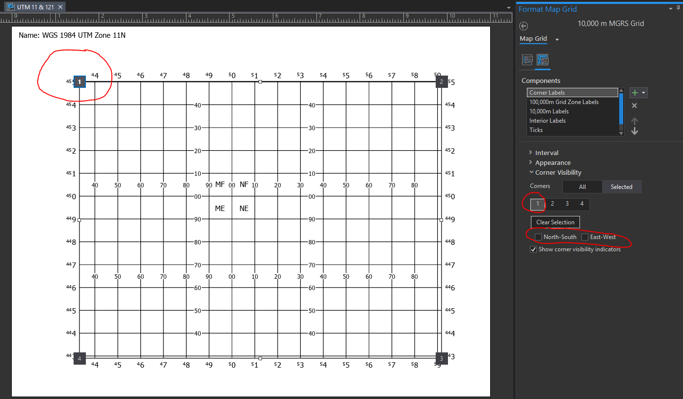
10. Select corner 3 (bottom right) and toggle the visibility on.
11. Select the 10,000 Labels.
12. Click Selected
13. Select edges 1 (top) and 4 (left) and toggle off the visibility for all directions.
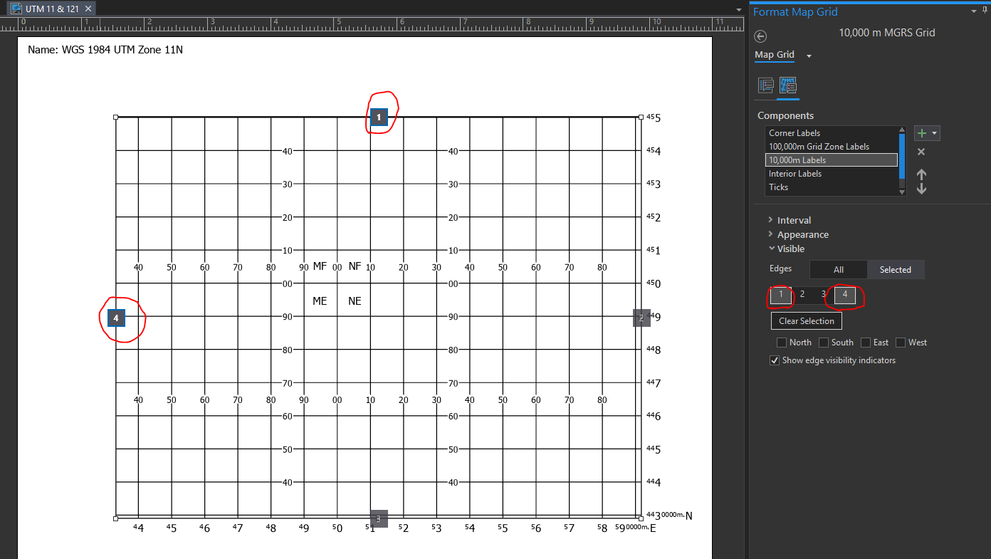
(Note: I'm doing this even though specific directions may not apply to this particular map just in case the map is later rotated or I save this grid out to a style that might be used for another map that is rotated. For a more complete discussion on this please see https://pro.arcgis.com/en/pro-app/help/layouts/mgrs-grids.htm).
14. Repeat for ticks.
Now I've got my MGRS (USNG) grid displaying labels/ticks on just the right and bottom (east and south for this particular map) I can add a measured grid for the UTM part and repeat the same steps above to set the label/tick visibility for the top and left.

Once you have the grids the way you like them you may want to consider saving the grid out to a style.
Hope this helps,
Tom
- Mark as New
- Bookmark
- Subscribe
- Mute
- Subscribe to RSS Feed
- Permalink
Hi Thomas,
You should be able to do this using Pro. You'll be adding two separate grids and defining label/tick visibility for each grid.
Assuming that your maps are in either the NAD83 or WGS84 datums you should be able to use the MGRS grids provided in the Grid Gallery for the USNG part.
Once you've added the grid you will want to define label/tick visibility.
1. Open the properties for the grid
2. Go to the Options tab & Expand the Edges and Corners group
3. Toggle on both check boxes
Here you'll see the edges and corners of your map frame defined. For example, the "top" is edge 1. The bottom right corner is corner 3.
Once the edges and corners are defined it is time to define label\tick visibility.
4. Switch to the Components tab in the Format Map Grid pane.
5. Select the Corner Labels component
6. Contract all the groups except for Corner Visibility to make the UI easier to work with
7. Click the Selected button to work with individual corners
8. Toggle on the Show corner visibility indicators (I tend to forget which corner is which)
9. Select corner 1 and toggle off the label pairs
10. Select corner 3 (bottom right) and toggle the visibility on.
11. Select the 10,000 Labels.
12. Click Selected
13. Select edges 1 (top) and 4 (left) and toggle off the visibility for all directions.
(Note: I'm doing this even though specific directions may not apply to this particular map just in case the map is later rotated or I save this grid out to a style that might be used for another map that is rotated. For a more complete discussion on this please see https://pro.arcgis.com/en/pro-app/help/layouts/mgrs-grids.htm).
14. Repeat for ticks.
Now I've got my MGRS (USNG) grid displaying labels/ticks on just the right and bottom (east and south for this particular map) I can add a measured grid for the UTM part and repeat the same steps above to set the label/tick visibility for the top and left.
Once you have the grids the way you like them you may want to consider saving the grid out to a style.
Hope this helps,
Tom
- Mark as New
- Bookmark
- Subscribe
- Mute
- Subscribe to RSS Feed
- Permalink
YES! That did it! I wasn't scrolling down far enough to see the MGRS Gallery! And the other tips have proven to be immensely helpful.