- Home
- :
- All Communities
- :
- Products
- :
- ArcGIS Pro
- :
- ArcGIS Pro Questions
- :
- MODIS NDVI data missing attribute table
- Subscribe to RSS Feed
- Mark Topic as New
- Mark Topic as Read
- Float this Topic for Current User
- Bookmark
- Subscribe
- Mute
- Printer Friendly Page
MODIS NDVI data missing attribute table
- Mark as New
- Bookmark
- Subscribe
- Mute
- Subscribe to RSS Feed
- Permalink
I am working on using MODIS images to compare NDVI values from 2000-2020 in the Inner Mongolian region of China. I am using 500m resolution 16 day images from the terra MODIS downloaded from AppEEARS. I downloaded the images and used the "extract by mask" tool and batch option to extract an NDVI raster for each year for a particular watershed boundary. From there I used the raster calculator to multiply each raster by 0.0001 (the scale factor of NDVI). Next I used raster calculator again to subtract each year from the previous year and generate a number of rasters showing the change in NDVI between each year from 2000-2020 (for example there is a raster showing changes in NDVI between 2000 and 2001, and 2001 and 2002, etc.). The problem I am having is that there are no attribute tables associated with these rasters. I have tried using "copy raster" to change the pixel type from floating 32 bit to 32 bit signed, but it changes all NDVI values to 0 for the copied raster. Even if I use "build raster attribute table" on the copied raster with a 32 bit signed pixel type, an attribute table does not appear after the tool runs. I need to know the areas associated with each increase or decrease in order to quantify the area of the watershed that increased or decreased in NDVI each year.
Solved! Go to Solution.
Accepted Solutions
- Mark as New
- Bookmark
- Subscribe
- Mute
- Subscribe to RSS Feed
- Permalink
floating point rasters don't have tables
If you need a table you may need to scale up your values by some factor, then take the integer of that
Int(raster * 100 )
but you will have to remember that the values are scaled up
... sort of retired...
- Mark as New
- Bookmark
- Subscribe
- Mute
- Subscribe to RSS Feed
- Permalink
yes 463*463 * 606 and assuming units are meters
... sort of retired...
- Mark as New
- Bookmark
- Subscribe
- Mute
- Subscribe to RSS Feed
- Permalink
floating point rasters don't have tables
If you need a table you may need to scale up your values by some factor, then take the integer of that
Int(raster * 100 )
but you will have to remember that the values are scaled up
... sort of retired...
- Mark as New
- Bookmark
- Subscribe
- Mute
- Subscribe to RSS Feed
- Permalink
Thank you so much for your response!
Is this operation "Int(raster * 100)" something I can do using the raster calculator tool?
- Mark as New
- Bookmark
- Subscribe
- Mute
- Subscribe to RSS Feed
- Permalink
Yes it is, Int is a spatial analyst raster function and you would just select your raster to replace raster in the equation... give it a try
... sort of retired...
- Mark as New
- Bookmark
- Subscribe
- Mute
- Subscribe to RSS Feed
- Permalink
Fantastic! I just tried this and it worked and produced a table. The table gives me the NDVI values and the count, which I am assuming is how many times they appear in the raster. Do you know if there is a way to also calculate how much area each NDVI value occupies?
- Mark as New
- Bookmark
- Subscribe
- Mute
- Subscribe to RSS Feed
- Permalink
Your raster cell size times the number of cells is the area of each class/value
... sort of retired...
- Mark as New
- Bookmark
- Subscribe
- Mute
- Subscribe to RSS Feed
- Permalink
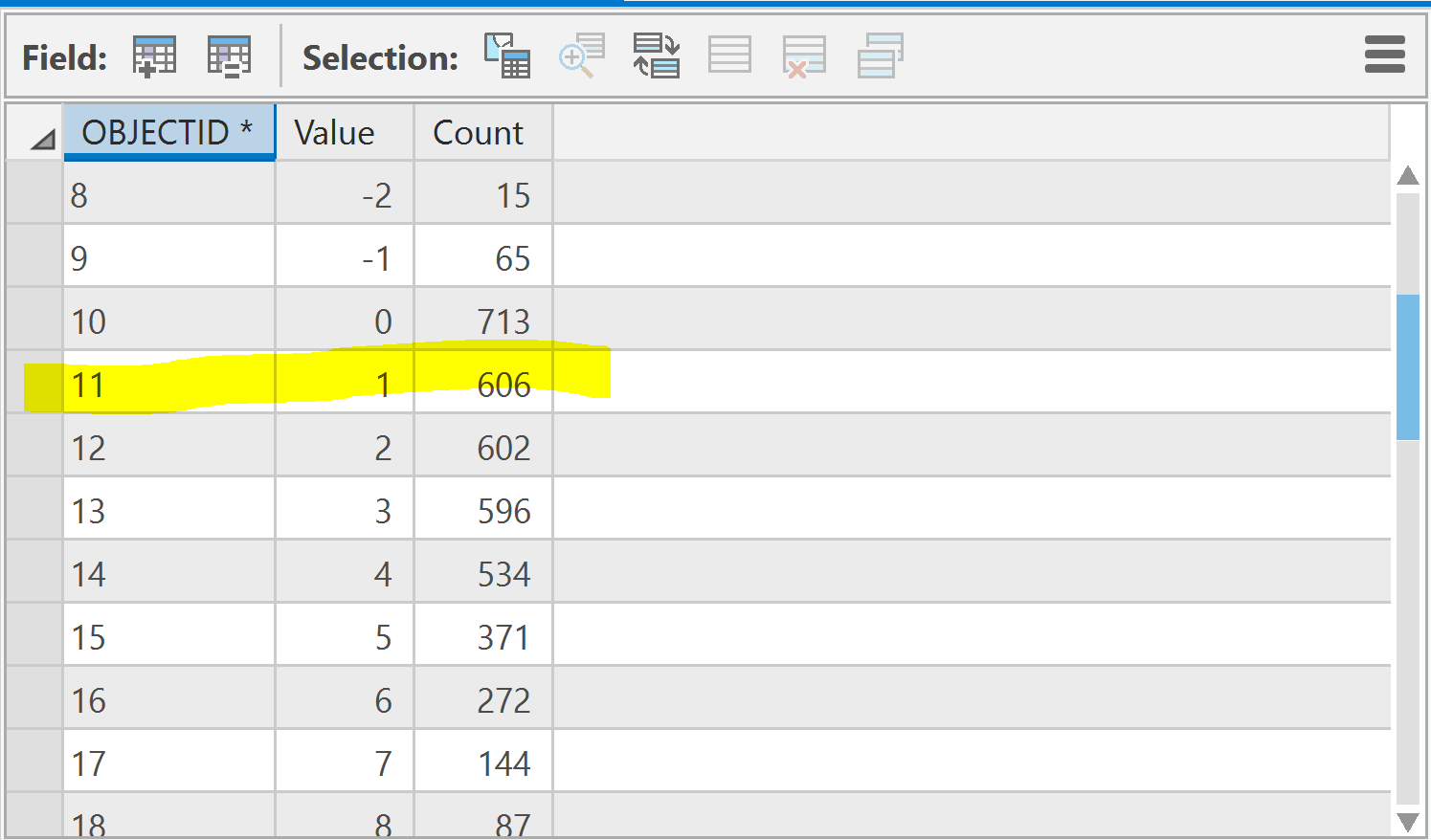
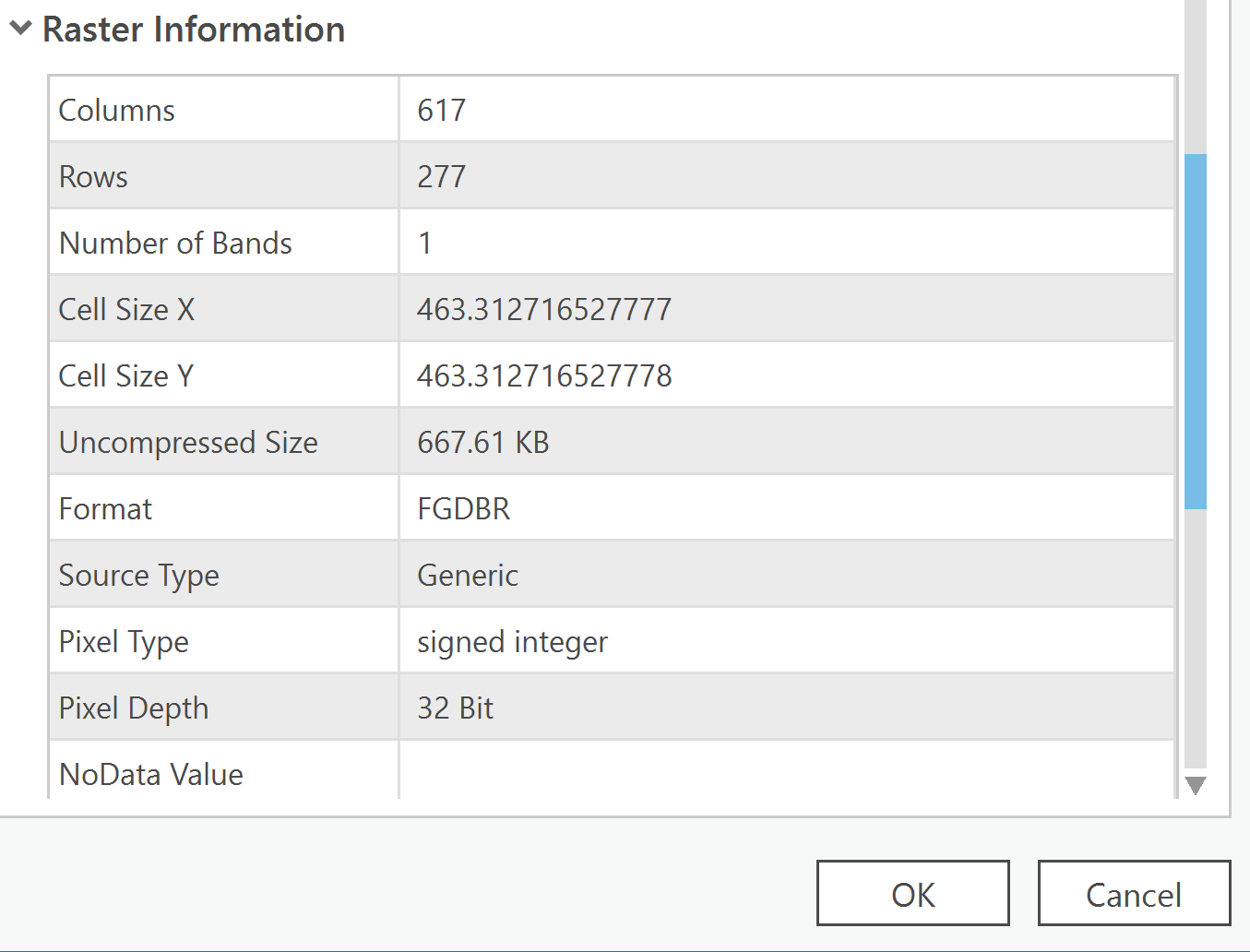
One last question to make sure I am understanding.
If my raster cell size is 463.312716527777 (shown in attached image) and the count for a value of 1 is 606 (shown in attached image), I need to multiply the two numbers together and the area would be the product with units of meters squared?
- Mark as New
- Bookmark
- Subscribe
- Mute
- Subscribe to RSS Feed
- Permalink
yes 463*463 * 606 and assuming units are meters
... sort of retired...
- Mark as New
- Bookmark
- Subscribe
- Mute
- Subscribe to RSS Feed
- Permalink
Thanks so much for all your help!