- Home
- :
- All Communities
- :
- Products
- :
- ArcGIS Pro
- :
- ArcGIS Pro Questions
- :
- Re: LAS won't load into LAS dataset
- Subscribe to RSS Feed
- Mark Topic as New
- Mark Topic as Read
- Float this Topic for Current User
- Bookmark
- Subscribe
- Mute
- Printer Friendly Page
LAS won't load into LAS dataset
- Mark as New
- Bookmark
- Subscribe
- Mute
- Subscribe to RSS Feed
- Permalink
Hello all. I am using ArcMap 10.5.1 with an Advanced license.
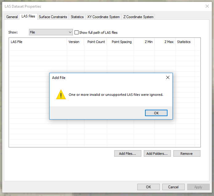
For some reason, I am unable to load LAS files unto my LAS dataset. Adding files through the LAS Dataset Properties gives me this error:
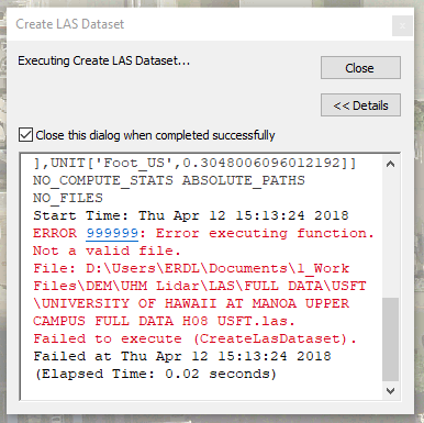
Going through the Create LAS Dataset route gives me this:
However, if I use an LAS dataset I have created in ArcMap 10.4.x, that same LAS data I am trying to create an LASD for appears on-screen, so the file itself is not corrupted.
Anyone have an idea what could be happening?
- Mark as New
- Bookmark
- Subscribe
- Mute
- Subscribe to RSS Feed
- Permalink
I'm having the same issue with a global mapper derived las 1.1 file.(or a program that our vendor uses has global mapper API).
I can't open it in Pro 2.1 or in ArcMap/Catalog 10.5.1
Error in Pro
Format not supported.
Failed to execute (CreateLasDataset).
Error in ArcMap is the same as above.
I used FME to up-convert the files to LAS 1.4
- Mark as New
- Bookmark
- Subscribe
- Mute
- Subscribe to RSS Feed
- Permalink
Has anyone figured this out? I'm on 10.6.1 and have the same issue. Some of my .las files will load into .lasd but some will not. The data isn't corrupt.
- Mark as New
- Bookmark
- Subscribe
- Mute
- Subscribe to RSS Feed
- Permalink
It might be best to contact Esri Support and share some files (that work and some that produce the error) so that they can see if they can reproduce the problem.
- Mark as New
- Bookmark
- Subscribe
- Mute
- Subscribe to RSS Feed
- Permalink
From what I've learned researching Esri Support Services records is that some of the *.las files are Version 1.0 but their point formats are set to 3 which is wrong. The result is throwing the error message. Version 1.0 point formats can be 0 and 1 only.
Additionally, I found 2 bugs that may explain what you're seeing:
NIM089327 - Certain LAS files cannot be added to a LAS dataset and result in the following error: "One or more invalid or unsupported LAS files were ignored." Steps to reproduce: This issue has been reviewed by product development and they found that the attached sample dataset contains 2 additional user defined bytes in the header which is causing the issue. The current LAS SR support does not take the user defined bytes into account when checking the total number of bytes after geo tags.
NIM087051 - An LAS file projected using LP360 fails to load into an LAS dataset in ArcGIS 10.1 SP1 with the error, "One or more invalid or unsupported LAS files were ignored." The same projected LAS file loads in ArcGIS 10.1 with no problems.
Not sure if this is the root cause of your error messages but it's a start.