- Home
- :
- All Communities
- :
- Products
- :
- ArcGIS Pro
- :
- ArcGIS Pro Questions
- :
- Re: Large decimal degree values when calculating g...
- Subscribe to RSS Feed
- Mark Topic as New
- Mark Topic as Read
- Float this Topic for Current User
- Bookmark
- Subscribe
- Mute
- Printer Friendly Page
Large decimal degree values when calculating geometry for latitude and longitude
- Mark as New
- Bookmark
- Subscribe
- Mute
- Subscribe to RSS Feed
- Permalink
Often we need to edit a polygon feature and recalculate a longitude and latitude field for the centroid of the feature. Historically, we have been doing this editing calculation within arcmap, but have been trying it out in ArcGIS pro.
Unfortunately when we try and calculate the centroid x-coordinate and centroid y-coordinate for longitude and latitude in decimal degrees we are getting very large values as compared to the workflow used in arcmap. It looks like the format is being displayed in meters.
Below are the setting we are using:

Here is the output of (Lat,Lon) for a test feature that was created.

Any ideas on how to reproduce the calculate geometry function from arcmap?
Thanks
- Mark as New
- Bookmark
- Subscribe
- Mute
- Subscribe to RSS Feed
- Permalink
what are you using to calculate the values? It looks like your data are in a projected coordinate system or it has been defined incorrectly as geographic when it is indeed projected
... sort of retired...
- Mark as New
- Bookmark
- Subscribe
- Mute
- Subscribe to RSS Feed
- Permalink
right-click on the layer, select properties, look for spatial reference.
Again, what did you use/do to calculate the values for the coordinates?
... sort of retired...
- Mark as New
- Bookmark
- Subscribe
- Mute
- Subscribe to RSS Feed
- Permalink
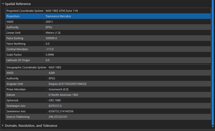
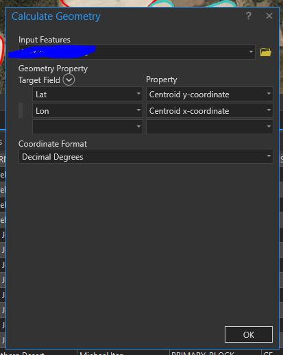
We are right clicking a field in the attribute table for the layer and clicking on 'Calculate Geometry'. I believe this is the same thing as using the 'Calculate Geometry Attributes' geoprocessing tool.
I've screenshot two images: The Calculate Geometry tool and the Spatial Reference information for the layer.
- Mark as New
- Bookmark
- Subscribe
- Mute
- Subscribe to RSS Feed
- Permalink
You do have a projected coordinate system, it seems that the long/lat output request isn't being supported
Use
Add Geometry Attributes (Data Management)—ArcGIS Pro | Documentation
to compare
... sort of retired...
- Mark as New
- Bookmark
- Subscribe
- Mute
- Subscribe to RSS Feed
- Permalink
So confirmed that the data are in a projected coordinate system.
Now try to get them calculated in a GCS NAD83 (geographic coordinate system) to get them in decimal degrees,
You might have missed the help section....
If a coordinate system is specified, the length and area calculations will be in the units of that coordinate system unless different units are selected in the Length Unit and Area Unit parameters.
... sort of retired...
- Mark as New
- Bookmark
- Subscribe
- Mute
- Subscribe to RSS Feed
- Permalink
O.k. GCS NAD83 did work for the coordinate system. Thank you.
Is this because I was using a PCS for my coordinate system but decimal degrees should be using a GCS?
- Mark as New
- Bookmark
- Subscribe
- Mute
- Subscribe to RSS Feed
- Permalink
Yes... GCS (geographic coordinate systems) are in decimal degrees.
PCS (projected coordinate systems) are usually in meters, but a few countries opt for feet (international or U.S.)
Datums are a whole different issue... basically describing Earth's shape (simply) so if those fundamentals change, then coordinate values will change for a fixed location on Earth... hence, referred to as "datum shift".
There are tons (or tonnes) of great references out there
... sort of retired...