- Home
- :
- All Communities
- :
- Products
- :
- ArcGIS Pro
- :
- ArcGIS Pro Questions
- :
- Re: Labelling woes... (in Pro or in ArcMap)
- Subscribe to RSS Feed
- Mark Topic as New
- Mark Topic as Read
- Float this Topic for Current User
- Bookmark
- Subscribe
- Mute
- Printer Friendly Page
Labelling woes... (in Pro or in ArcMap)
- Mark as New
- Bookmark
- Subscribe
- Mute
- Subscribe to RSS Feed
- Permalink
I am not sure there is an "easy" answer to this but I have given up and am relying on GeoNet to pull me out of a jam.
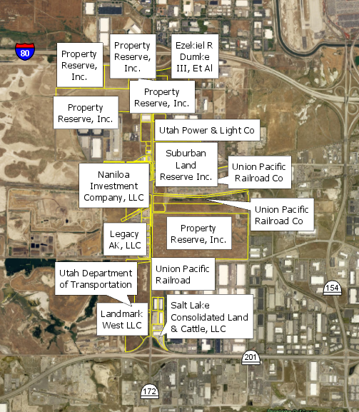
Is there an "easy button" for labelling just the way I want it? Here are about 66 polygons that need labels visible for each one and need to see the polygon. In Pro, this is how they look without much change in the properties:

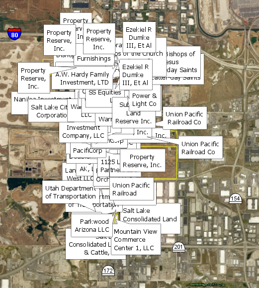
I want to see all the labels so I choose Never remove. This is what I get:

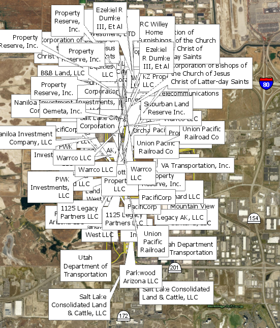
Even if I throw in a 50 point offset, 200 point max overrun, 50% buffer, 100 point feature weight to interior and boundary features (and other tweaks), this is my result:

Is there some sort of magic button that will not allow labels to overlap each other? I have attempted to mess around with all of the settings in the label properties and have not come up with a good solution (I do have Maplex Label Engine turned on). My best bet is to convert to annotations and move them that way, manually, by hand, one at a time. (small snippet:  )
)
I keep thinking I'm missing something super obvious. Tell me where I can find the easy button (in ArcGIS Pro preferably or ArcMap - it doesn't matter). Thanks!
- Mark as New
- Bookmark
- Subscribe
- Mute
- Subscribe to RSS Feed
- Permalink
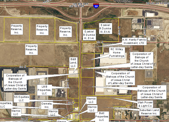
You are showing two different scales above --- one where the problem is occurring and a much larger scale giving more room for placement. I produce as a report sign maps and have similar issues. Some tips I can give is to:
- Use maplex
- Tweak and design labels at a set scale that you wish to print at (This gives you your placement options vs label sizes)
- Font size
- Symbol Size
- Offsets
- Abbreviations
- Placement options around the polygon
For me on my sign maps -- It was so crowded at the print scale ultimately I had you go the annotations. However I do use the above tips to place the labels prior to converting to annotations so that most of the labels are OK as is and only have to hand place a few (or fewer).....
- Mark as New
- Bookmark
- Subscribe
- Mute
- Subscribe to RSS Feed
- Permalink
Nice catch Ted; they are at different scales.
I normally go through those exact same tips. Unfortunately my clients do not normally like abbreviations or smaller font/symbol size. Also, when a certain PDF size is requested, there usually isn't much wiggle room.
I was just hoping for some kind of magic 'repellent' that I can insert that would make labels shy away from it (like the opposite or a magnet). Thanks for the help!
- Mark as New
- Bookmark
- Subscribe
- Mute
- Subscribe to RSS Feed
- Permalink
I sorta figured that.... there was one trick I used to some success on crowded map ... sorta like a repellent. I created a big buffer around the objects I wanted to label and added the labeling data to the buffer and set the rules for labeling to occur outside of the buffer (of course the buffer was invisible) --- the buffer was my repellent away from the map focus. That was a lot of trial and error and personally I don't know if it is worth the end results. If I have to print a map more once for a client--- Annotations is the way to go.
- Mark as New
- Bookmark
- Subscribe
- Mute
- Subscribe to RSS Feed
- Permalink
Ted, I like the invisible bubble buffer! But, yeah I can see how that would be a lot of trial and error. Maybe ArcGIS-Pro-X-Factor-Info version 92 will have the answer we need! (What I'm saying is, I don't see there be a 'solution' any time soon for this).
Thanks!
- Mark as New
- Bookmark
- Subscribe
- Mute
- Subscribe to RSS Feed
- Permalink
My observation is that Never Remove causes all the other rules to not work well. They seem to be ignored in ArcMap (don't have Pro yet). I never use it because I don't have confidence that I can tell what's going on, even though I am hugely experienced with Maplex. If you're overriding rules, you don't learn the rules well, right?
You could try the simple callout style background text with just leader lines, or as you did, just halos/masks. It looks in the early example that Maplex is trying to not cross those big talk-bubble leaders. It also looks like your not letting the fonts scale smaller.
Rather than converting everything to annotation, I get labels to fit sometimes by selecting out the nonplacers into a different labeling class with perhaps smaller fonts or other options that help labels fit. The final label rendered by the second could have been drawn by one class (it is not smaller than my minimum scale), but it won't. I have an untested theory that having two classes keeps the placement battle shorter or simpler, so the label engine does not give up on any labels. I have 2 it particularly dislikes, so I do sometimes put these in a map annotation class called Unplaced.
- Mark as New
- Bookmark
- Subscribe
- Mute
- Subscribe to RSS Feed
- Permalink
Dana, that's an interesting theory on having two classes in order to show the unplaced labels. I like that!
I guess in some cases my needs will outweigh any label options thus forcing me to use annotations. What I mean is, this particular map (and other ones like it) need to show most of the polygon boundary and give it a big fat label. If the label fits fully inside the polygon then perfect! If not, then I likely have to move it completely outside with the leader pointing in the middle somewhere.
- Mark as New
- Bookmark
- Subscribe
- Mute
- Subscribe to RSS Feed
- Permalink
You can do that in Maplex with 1 or 2 label classes, 1 for a polygon. You can choose the 'can place label outside' option with place inside the polygon as the primary choice, and limit or prevent label overrun. The leader lines won't show on the inside placement, and the bigger polygons or polygons in less crowded areas will be labeled inside, the smaller, with leader line, outside placement.
- Mark as New
- Bookmark
- Subscribe
- Mute
- Subscribe to RSS Feed
- Permalink
As you have already figured out there is no magic 'place all labels perfectly' button in ArcMap or ArcGIS Pro. To get the most from the Maplex Label Engine you need to fully utilise the placement properties and try the options that Ted has suggested.
I will add that there is a preferred offset setting in Maplex where you define the preferred offset as a value and specify a range within which the label is allowed to place. See below for where this option is in ArcGIS Pro.

Hope that helps.
- Mark as New
- Bookmark
- Subscribe
- Mute
- Subscribe to RSS Feed
- Permalink
Hi Samuel,
Thanks for the reply. I have played around with these values many times to try and trick the system into doing what I want it to do. I have not had the results I wanted from it.
- Mark as New
- Bookmark
- Subscribe
- Mute
- Subscribe to RSS Feed
- Permalink
For my two cents, it depends if you need to do this many times or just once. If just once, bite the bullet and manually place annotations. If many times, add a number column to your parcel layer, edit the numbers so they will label in a logical order, label with those numbers, and place a number/name table on the map (I've done this on more maps than I care to admit).