- Home
- :
- All Communities
- :
- Products
- :
- ArcGIS Pro
- :
- ArcGIS Pro Questions
- :
- Re: Kriging command from python ignores cell size?
- Subscribe to RSS Feed
- Mark Topic as New
- Mark Topic as Read
- Float this Topic for Current User
- Bookmark
- Subscribe
- Mute
- Printer Friendly Page
Kriging command from python ignores cell size?
- Mark as New
- Bookmark
- Subscribe
- Mute
- Subscribe to RSS Feed
- Permalink
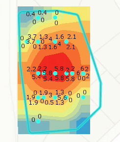
I'm working on creating a batch kriging tool using the Emperical Bayesian Kriging tool. When I run the tool in ArcGIS pro on a selected set of features, the tool runs and creates a nice looking output raster. It looks like this:
But when I copy that exact tool output from a python window, I get the following code:
arcpy.ga.EmpiricalBayesianKriging("pond_depth_points", "Water_dept", "point_geostat", r"K:\01696-360\GIS\Maps\2018 Pond Assessment\2018 Pond Assessment.gdb\pond_empbkrig_1", 0.0001953125, "NONE", 100, 1, 100, "NBRTYPE=StandardCircular RADIUS=0.028516880589107 ANGLE=0 NBR_MAX=15 NBR_MIN=10 SECTOR_TYPE=ONE_SECTOR", "PREDICTION", 0.5, "EXCEED", None, "POWER")
# which I translate to this in my layer loop:
def create_raster(points, workspace, row_data, depth_field):
raster_name = "kriging_{0}".format(row_data[0])
try:
# raster = arcpy.Kriging_3d(points, depth_field, join(workspace, raster_name), "Spherical ,0.000005", 0.0000953125, "Variable 12")
# arcpy.ddd.Kriging(points, depth_field, join(workspace, raster_name), "Spherical 0.000195 # # #", 0.0001953125, "VARIABLE 12 0.00015", None)
# raster = arcpy.Kriging_3d(points, depth_field, join(workspace, raster_name),"Spherical 0.2", "0.2", "VARIABLE 8", "")
output_filename = join(workspace, raster_name)
output_geostat = 'point_geostat'
cell_size = 0.0001953125
transformation = "NONE"
max_points = 100
local_overlap_factor = 1
simulated_semio = 100
search_neighborhood = "NBRTYPE=StandardCircular RADIUS=0.028516880589107 ANGLE=0 NBR_MAX=15 NBR_MIN=10 SECTOR_TYPE=ONE_SECTOR"
output_type = "PREDICTION"
semio_model_type = "POWER"
arcpy.ga.EmpiricalBayesianKriging(points, depth_field, output_geostat, output_filename,
cell_size, transformation, max_points,
local_overlap_factor, simulated_semio, search_neighborhood,
"PREDICTION", 0.5, "EXCEED", None, semio_model_type)
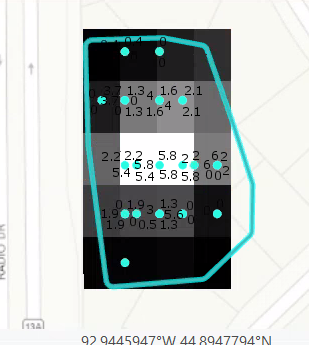
When I run this tool and add the output raster to the map, the output raster looks like this. I also noticed the output of the above tool when added to the map also looks like this. Why? Am I doing something wrong here?
Solved! Go to Solution.
Accepted Solutions
- Mark as New
- Bookmark
- Subscribe
- Mute
- Subscribe to RSS Feed
- Permalink
Your input coordinates were geographic?
I suspect that you might want to read this
What is Empirical Bayesian kriging?—ArcGIS Pro | ArcGIS Desktop the Distance calculations for data in geographic coordinates section.
Repeat your procedure on projected data, to see if the issue is resolved
- Mark as New
- Bookmark
- Subscribe
- Mute
- Subscribe to RSS Feed
- Permalink
Please do the following in ArcGIS Pro
- right click the raster that you created in Pro
- on the Source tab, expand Raster Information
- note the cell size
- repeat the above using the raster you created via the Python script
Are the cell size the same?, they should be.
Now let us have a look at the rendering.
- Click on the raster you created in Pro
- on the Ribbon -> Appearance Tab click on Symbology
Have a look the custom symbology that is created for the output raster when done in the app.
Now do the same for the raster created via the script, it used the default renderer.
You can manually change the symbology or if you click on the "Burger" button on the symbology pane you can import the symbology.
-Steve
- Mark as New
- Bookmark
- Subscribe
- Mute
- Subscribe to RSS Feed
- Permalink
Your input coordinates were geographic?
I suspect that you might want to read this
What is Empirical Bayesian kriging?—ArcGIS Pro | ArcGIS Desktop the Distance calculations for data in geographic coordinates section.
Repeat your procedure on projected data, to see if the issue is resolved
- Mark as New
- Bookmark
- Subscribe
- Mute
- Subscribe to RSS Feed
- Permalink
Yeah, the data was definitely not projected. Projecting the data fixed the issue. Thank you Dan.