- Home
- :
- All Communities
- :
- Products
- :
- ArcGIS Pro
- :
- ArcGIS Pro Questions
- :
- In ArcMap I can select the "Go To XY" tool, input ...
- Subscribe to RSS Feed
- Mark Topic as New
- Mark Topic as Read
- Float this Topic for Current User
- Bookmark
- Subscribe
- Mute
- Printer Friendly Page
In ArcMap I can select the "Go To XY" tool, input my X and Y values, and then select the "Add Point" button and a marker is created at that location. Does ArcGis Pro have this fuctionality.
- Mark as New
- Bookmark
- Subscribe
- Mute
- Subscribe to RSS Feed
- Permalink
- Report Inappropriate Content
Adding a "Marker" in Pro.
- Mark as New
- Bookmark
- Subscribe
- Mute
- Subscribe to RSS Feed
- Permalink
- Report Inappropriate Content
Benny - yes, you can do this in AGP as well - it's just a little different. On the Map core tab, in the Inquiry group, click the Locate command. In the Locate Pane, type in your XY coordinates, hit Enter. The results are populated in the Locate Pane. Right-click on the one of interest and select Zoom To or Pan To. If a Point feature class exists in the Map View, then you choose "Add to feature class" and then it's stored in your geodatabase or shapefile. Hope this helps!
- Mark as New
- Bookmark
- Subscribe
- Mute
- Subscribe to RSS Feed
- Permalink
- Report Inappropriate Content
What if there are multiple point feature classes in your map view, how does Pro know which point feature class to add the point to if you are always in editable mode?
- Mark as New
- Bookmark
- Subscribe
- Mute
- Subscribe to RSS Feed
- Permalink
- Report Inappropriate Content
One thought that comes to mind is in the Contents Pane, select List by Editing and disable all point feature classes save for the one you want to add the point to. Should work fine.
- Mark as New
- Bookmark
- Subscribe
- Mute
- Subscribe to RSS Feed
- Permalink
- Report Inappropriate Content
Why would "Add to Feature Class" be grayed out if it is stored in a file geodatabase that I just created myself?
- Mark as New
- Bookmark
- Subscribe
- Mute
- Subscribe to RSS Feed
- Permalink
- Report Inappropriate Content
Mine was showing the same thing. From the AGP Help, here's what you have to do. After searching for your XY point, click the Edit core tab, click Create in the Features group. In the Create Features pane, select the Point construction tool from the point feature template. Now go back to the Locate Pane, right-click and the "Add to Feature Class" is enabled. Not sure why this workflow is designed this way. Perhaps to ensure that the point goes into the correct point feature class as you asked earlier in the thread?
- Mark as New
- Bookmark
- Subscribe
- Mute
- Subscribe to RSS Feed
- Permalink
- Report Inappropriate Content
Thanks for the additional info.
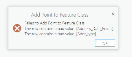
I tested to see if I could manually add a point which I was able to do where I used the Create Features tool. I then went back to creating the point the way you indicated with through the Locate pane, but then I received this error:

Any ideas on why this would occur and how I could resolve this issue?
- Mark as New
- Bookmark
- Subscribe
- Mute
- Subscribe to RSS Feed
- Permalink
- Report Inappropriate Content
Interesting. Is your target a shapefile or gdb feature class? Also, create a copy of the feature class, delete the 2 fields and try again. Does the error persist with any other fields?
- Mark as New
- Bookmark
- Subscribe
- Mute
- Subscribe to RSS Feed
- Permalink
- Report Inappropriate Content
I deleted the Addr_Type field from a copy of the file gdb feature class and I was then able to add the point from the Locate pane. The Addr_Type field was nothing unusual with Data Type = Text and Length of 20, although it was a field that is added in a geocode geoprocess.
Also when you type in an xy value in the Locate pane, it provides 2 results with the x and y coordinates being swapped. Is this the expected behavior when using the Pro Locate pane to search for an xy location?
- Mark as New
- Bookmark
- Subscribe
- Mute
- Subscribe to RSS Feed
- Permalink
- Report Inappropriate Content
I wonder if the geocode geoprocess of adding the field causes it to be perhaps be "read-only" or some other strangeness???
With regard to the 2 results, this has to do with the Providers of the Locate Pane. If you click Settings (to the right of Locate in the upper part of the Pane), you'll see that there is XY Provider, ArcGIS World Geocoding Service and I have a SampleServer6 for my Locate Providers. If you uncheck say 2 of the 3 leaving only XY Provider, then your search should only return one result.