- Home
- :
- All Communities
- :
- Products
- :
- ArcGIS Pro
- :
- ArcGIS Pro Questions
- :
- Re: Importing editable layers.
- Subscribe to RSS Feed
- Mark Topic as New
- Mark Topic as Read
- Float this Topic for Current User
- Bookmark
- Subscribe
- Mute
- Printer Friendly Page
Importing editable layers.
- Mark as New
- Bookmark
- Subscribe
- Mute
- Subscribe to RSS Feed
- Permalink
Hi, I'm trying to import an editable layer into Arc Pro. I've tried .csv, .txt, and even converted it to a Geoprocessing file. I'm able to import it to the map, but then am never able to edit the layer and it always shows up as a non-editable layer in the context tab.
Any advice?
Thanks.
- Mark as New
- Bookmark
- Subscribe
- Mute
- Subscribe to RSS Feed
- Permalink
what type of file was it?
Have you tried to make a copy and edit it?
And the obvious... do you have full permissions on your machine? and are you editing the file on your machine? or was the source file on some restricted location?
- Mark as New
- Bookmark
- Subscribe
- Mute
- Subscribe to RSS Feed
- Permalink
Hi Dan, thanks for your reply. It was a .txt file that I imported. I was able to import it just fine with no problem, and looking at the "Standalone Table Properites" under "Data Source", the data type that it is listed as is File Geodatabase Table. It also has ObjectID Field.
I have tried copying it and reimporting it as well, with no luck to make edits to it.
I made sure the permissions allowed me to do everything I wanted to be able to do as well.
I will be editing the points in ArcGIS, as I need to see them referenced to locations on the map in order to edit them, so I can't really edit them outside of ArcGIS.
Appreciate your help.
- Mark as New
- Bookmark
- Subscribe
- Mute
- Subscribe to RSS Feed
- Permalink
Travis - if you add CSV or text files, you most likely fail because your data misses the required ObjectID field. See this help topic for explanation (plus this might help, too). You cant edit, do a definition query, select by attribute ... right?
You either have to store this data as real tables ( see hlep topic above) or edit the data in its original *.txt/*.csv files (so most likely outside ArcGIS or with a python routine) and then refresh your data in ArcMap and you'll see the changes.
- Mark as New
- Bookmark
- Subscribe
- Mute
- Subscribe to RSS Feed
- Permalink
Thank you for your reply Gunter.
I followed the links you provided and wasn't able to come up with anything, as the ObjectID fields are set to "yes".
You are correct that I can't edit or select anything with that data. However, I cannot really edit outside of ArcGIS, as I need to be able to reference the locations on a map while I am editing that data and see the changes in an active window in real-time.
Any more advice?
Thank you very much.
- Mark as New
- Bookmark
- Subscribe
- Mute
- Subscribe to RSS Feed
- Permalink
It is the layer I am having trouble with, not the table I believe
- Mark as New
- Bookmark
- Subscribe
- Mute
- Subscribe to RSS Feed
- Permalink
Hi Travis,
it is not the NAME of a field that makes it an ObjectID - it is the field type. And this you can not set/get with a *.csv or text file (see graphic, only if the field is of TYPE Object ID it is accepted as such).
I am afraid but you will have to store the data in a real table to do what you want. ... At least that is my level of knowledge. I never ever managed to use a *.csv or *.txt or *.tab file and edit the file through ArcMap/ArcGIS Pro.
- Mark as New
- Bookmark
- Subscribe
- Mute
- Subscribe to RSS Feed
- Permalink
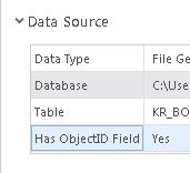
Thank you for the prompt response Gunter. The stand alone table turns out to have an ObjectID, but then when I convert it to a layer, that goes away and the layer becomes uneditable. This is what the I find under "Properties" and "Source" for the stand alone table.

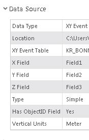
However when I switch to the layer, this is what I find:

I won't be able to do what I need to if I store the data in a real table and then edit it.
Thank you.
- Mark as New
- Bookmark
- Subscribe
- Mute
- Subscribe to RSS Feed
- Permalink
Hi Travis,
When you make an XY layer from a standalone txt or csv table, the layer table doesn't have an OBJECTID field--as you noted. Also, the table is not editable. You're not doing anything wrong. That's how the software works. To make it editable, you have to export the XY layer to a feature class.
You said "I won't be able to do what I need to if I store the data in a real table and then edit it." What is that you need to do?
Tim
- Mark as New
- Bookmark
- Subscribe
- Mute
- Subscribe to RSS Feed
- Permalink
Thank you Tim. I will see what I can do with that.
I have surveyed topography data and need to edit out some features out of that data to model a "what-if" scenario.