- Home
- :
- All Communities
- :
- Products
- :
- ArcGIS Pro
- :
- ArcGIS Pro Questions
- :
- How to use projection information in WKT form to d...
- Subscribe to RSS Feed
- Mark Topic as New
- Mark Topic as Read
- Float this Topic for Current User
- Bookmark
- Subscribe
- Mute
- Printer Friendly Page
How to use projection information in WKT form to define projection for a raster?
- Mark as New
- Bookmark
- Subscribe
- Mute
- Subscribe to RSS Feed
- Permalink
I have a raster file with Unknown Coordinate System and a WKT-file that has the CS information. How do it connect those two in ArcGIS Pro? The Define Projection tool gives me an option to create a new coordinate system, but I'm not sure which information in the WKT-file is needed. Thanks!
- Mark as New
- Bookmark
- Subscribe
- Mute
- Subscribe to RSS Feed
- Permalink
open it up in a text editor and post what it says if you can't interpret it
Well-known text representation of coordinate reference systems - Wikipedia
... sort of retired...
- Mark as New
- Bookmark
- Subscribe
- Mute
- Subscribe to RSS Feed
- Permalink
Thank you Dan! The link you shared was very helpful.
Based on that it seems the WKT-file includes conversion between two coordinate systems. Does this mean the Define Projection -tool should be used with the BASEGEOGCRS and then the Project Raster -tool with the information after CONVERSION?
The text file is attached here below.
- Mark as New
- Bookmark
- Subscribe
- Mute
- Subscribe to RSS Feed
- Permalink
You can right-click on the layer and select Properties and look at the extent values .... or
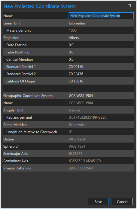
Open a new map, no basemap etc, just add the raster, set the map to display the coordinates of the raster. It will set the coordinate system for the map. scroll around, if the coordinates don't look like decimal degrees (eg small) then the raster was projected to... METHOD["Albers Equal Area",
ID["EPSG",9822]],
... sort of retired...
- Mark as New
- Bookmark
- Subscribe
- Mute
- Subscribe to RSS Feed
- Permalink
You don't need to create one if you know where it is for... pick one

... sort of retired...
- Mark as New
- Bookmark
- Subscribe
- Mute
- Subscribe to RSS Feed
- Permalink
Thanks Dan! I know where the raster is/should be located (Alaska Albers) but the parameters of the projection in the ArcGIS selection do not match with the parameters in the WKT-file. However, I did try the Define Projection -tool and used Alaska Albers to see what happens, but the raster still opens at the origin of the projection grid (west of the island of Haida Gwaii, about 500 km out at the sea). Does this mean that the raster was created with wrong coordinate information?
- Mark as New
- Bookmark
- Subscribe
- Mute
- Subscribe to RSS Feed
- Permalink
try creating it then... maybe it didn't use an Alaska albers (never know... Yukon is nearby 😉 )
... sort of retired...
- Mark as New
- Bookmark
- Subscribe
- Mute
- Subscribe to RSS Feed
- Permalink
Neither Yukon or Alaska works, and even with the new one that I created based on the WKT the raster is still located in the middle of the sea. Is it safe to say now that something is wrong, or am I just not getting something?
- Mark as New
- Bookmark
- Subscribe
- Mute
- Subscribe to RSS Feed
- Permalink
I suspect it is wrong then ... back to the source of the data to find out what is going on
... sort of retired...