- Home
- :
- All Communities
- :
- Products
- :
- ArcGIS Pro
- :
- ArcGIS Pro Questions
- :
- Re: How small a feature can I digitize in ArcMap/A...
- Subscribe to RSS Feed
- Mark Topic as New
- Mark Topic as Read
- Float this Topic for Current User
- Bookmark
- Subscribe
- Mute
- Printer Friendly Page
How small a feature can I digitize in ArcMap/ArcPro?
- Mark as New
- Bookmark
- Subscribe
- Mute
- Subscribe to RSS Feed
- Permalink
A colleague of mine is trying to digitize features as small as 2 millimetres. We are finding that at around sub 4mm all features seem to simplify to a triangle even if he uses 3+ vertices or show an error. A test drawing a 4x4mm rectangle is OK, if I go below 4mm I get a message " The feature could not be created, the geometry is invalid".
If I digitize a polygon with 3+ vertices with any one length below 4mm it simplifies to a triangle.
Snapping is off.
He needs to do this as part of his grain size analysis derived from drone imagery and needs to run the Minimum bounding tool on the digitized features.
We have tried shapefile and FGDB polygon, various coordinate systems including nothing, all in ArcMap 10.6.1.
In ArcPro 2.4.3 we can't zoom in beyond 1:1 so it's difficult to see but it looks as it too has similar limits.
How small should we be able to digitize in Arc, are there limits documented anywhere? It seems any line segment less than 4mm causes the issue or is there a perimeter/area minimum threshold?
Thanks - Mark
- Mark as New
- Bookmark
- Subscribe
- Mute
- Subscribe to RSS Feed
- Permalink
I am not sure if there are "limits" to the size of a feature documented. I would say that the projection would be taken into account and zooming past 1:10 can create some feature weirdness.
Does the imagery even have that resolution of pixel size for detection?
- Mark as New
- Bookmark
- Subscribe
- Mute
- Subscribe to RSS Feed
- Permalink
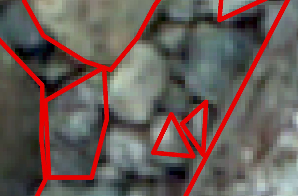
Yes, it was captured using a Sony A6000 camera on a drone (lots of overlapping images) at low alt. then processed in AgiSoft, here is an example - if you squint you can make out the grains. The cell size in 0.3mm
- Mark as New
- Bookmark
- Subscribe
- Mute
- Subscribe to RSS Feed
- Permalink
I just have to wonder if using a GIS is the appropriate tool for such an endeavor. What about using a point feature to represent what ever it is you are digitizing and store the dimensions in the attributes table ?
- Mark as New
- Bookmark
- Subscribe
- Mute
- Subscribe to RSS Feed
- Permalink
Sure, but he wants to use the ArcGIS Minimum Bounding Geometry tool.
- Mark as New
- Bookmark
- Subscribe
- Mute
- Subscribe to RSS Feed
- Permalink
Okay, but as George Thompson alludes to, what projection is being used? Therein lies my question regarding appropriate use. The old saying comes to mind: If the only tool a guy has is a hammer, everything looks like a nail...
- Mark as New
- Bookmark
- Subscribe
- Mute
- Subscribe to RSS Feed
- Permalink
The original PCS is WGS84 UTM Zone 30 (to cover the UK)