- Home
- :
- All Communities
- :
- Products
- :
- ArcGIS Pro
- :
- ArcGIS Pro Questions
- :
- Re: How do I remove the 180th meridian line on my ...
- Subscribe to RSS Feed
- Mark Topic as New
- Mark Topic as Read
- Float this Topic for Current User
- Bookmark
- Subscribe
- Mute
- Printer Friendly Page
How do I remove the 180th meridian line on my map of Russia?
- Mark as New
- Bookmark
- Subscribe
- Mute
- Subscribe to RSS Feed
- Permalink
- Report Inappropriate Content
I'm not sure how to remove the line that represents the 180th meridian (international dateline) on my polygon. I have the "Russia Country Boundary 2017" feature layer added from the Living Atlas. My Projected Coordinate System is set to "Asia North Albers Equal Area Conic". I've tried to google this question, but I haven't come across an answer I can fully understand. I'm a student and very new to all this!
Thank you!
The line is actually a gap between the polygons.
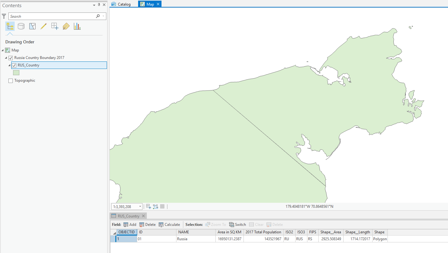
Using ArcGIS Pro 2.3.1
ANSWER:
Thanks to everyone below, it turns out I was not projecting correctly, which was creating issues down the line when editing polygons. Here's what I did...
- Start a blank project in ArcGIS. Insert new map, go into its properties, change the Coordinate System to "Asia North Albers Equal Area Conic".
- Add "World Countries (Generalized)" from the Living Atlas. Select Russia and Export Features to new feature class layer.
- Search and select the Project tool from Analysis>Geoprocessing>Tools.
- Select the Russia layer for input. Select "Current Map" for Output Coordinate System. Run.
- Now edit the polygons to close the gap and merge to remove any lines. All done!
Hope this helps. The only thing that bothers me with this fix is the addition of shape area (484,914.49674 m²) and shape length (4.59 m) to the original Russia polygon. These numbers could be different depending on how you close the gap, and possibly affect data projections depending on your use of this map? IDK, but thank you everyone who helped get us this far!
Solved! Go to Solution.
- Mark as New
- Bookmark
- Subscribe
- Mute
- Subscribe to RSS Feed
- Permalink
- Report Inappropriate Content
Hey Kate, so my issue was projecting on the fly, when I should have used the Projection tool for the layer instead. It finally works now! Thanks for all the help!
- Mark as New
- Bookmark
- Subscribe
- Mute
- Subscribe to RSS Feed
- Permalink
- Report Inappropriate Content
No problem! Oh yes, projection tool is the way to go. And there are tons of resources on using the correct spatial references - seems so easy but there's a lot to line up! Good luck on your project.
- Mark as New
- Bookmark
- Subscribe
- Mute
- Subscribe to RSS Feed
- Permalink
- Report Inappropriate Content
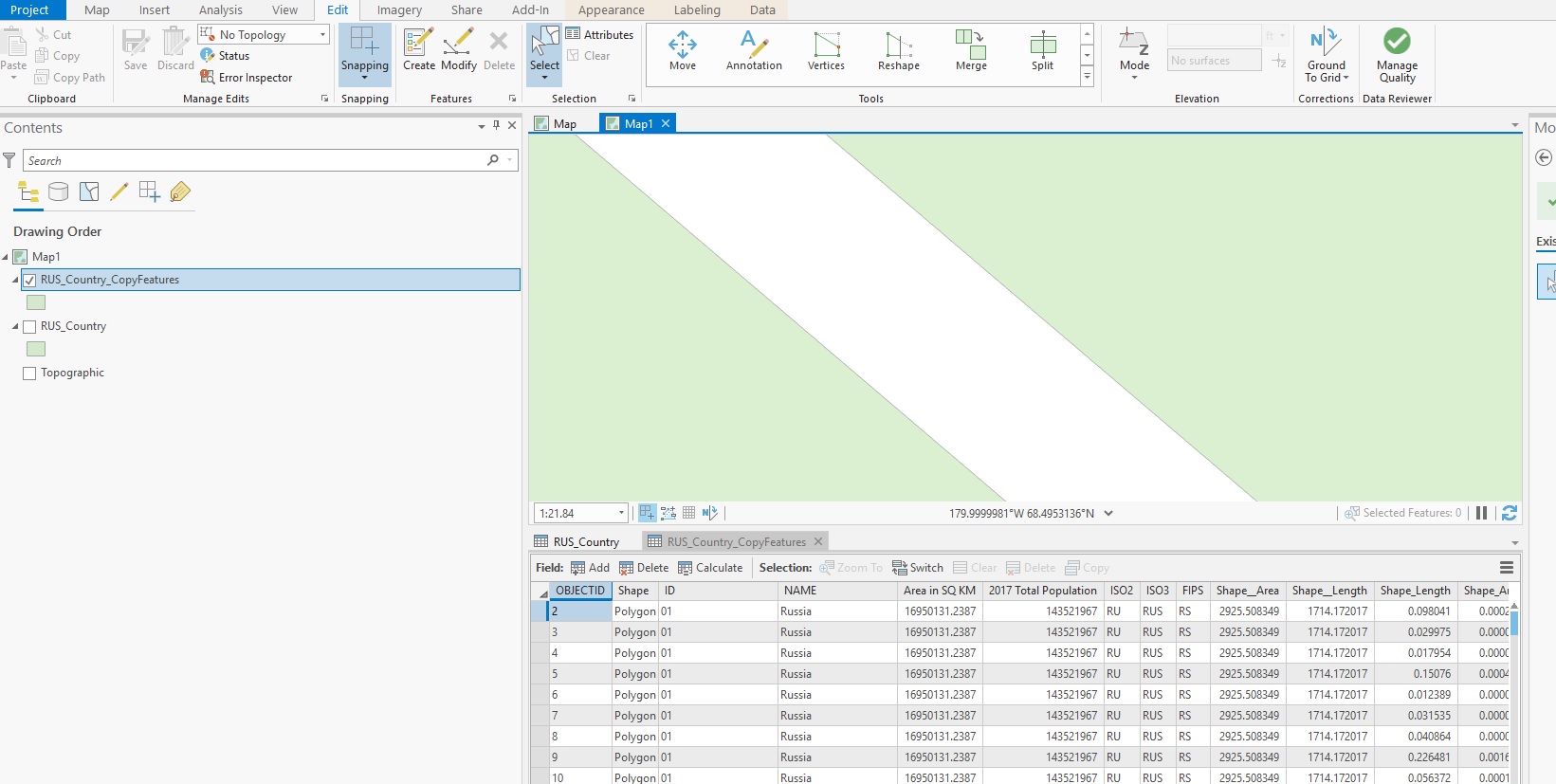
I just saw that you are new to this. First you cannot edit the layer directly from the Living Atlas. Right click the layer and export it. Next use the explode tool, this will break it into all individual features. Next select the two and Merge. I just did this on the same layer and it turns out there is a tiny gap between the two. For it to be seamless you need to draw a polygon over the gap, snapping to the boundaries, select the features and Merge.
- Mark as New
- Bookmark
- Subscribe
- Mute
- Subscribe to RSS Feed
- Permalink
- Report Inappropriate Content
Good to know about the Living Atlas, thanks. But I'm still stuck on the next step. If you look up at my other post, you'll see that anything I draw over the meridian is split into separate parts.
- Mark as New
- Bookmark
- Subscribe
- Mute
- Subscribe to RSS Feed
- Permalink
- Report Inappropriate Content
Thanks for the help. I finally figured out that I needed to use the Project tool, not project on the fly, before attempting any of this. Thanks!
- Mark as New
- Bookmark
- Subscribe
- Mute
- Subscribe to RSS Feed
- Permalink
- Report Inappropriate Content
- Mark as New
- Bookmark
- Subscribe
- Mute
- Subscribe to RSS Feed
- Permalink
- Report Inappropriate Content
More info: What happens to features at +/-180 (dateline)?—Help | ArcGIS for Desktop
In a nutshell, mathematically those points are nowhere near each other. By creating a new feature class following the instructions in my original post and setting the X/Y domain as specified in step 4, you should then be able to copy the data from the original into the new feature class. You should then be able to view the polygon without the line at the 180th meridian. This technique effectively moves the problem to the 0, or 360 meridian.
- Mark as New
- Bookmark
- Subscribe
- Mute
- Subscribe to RSS Feed
- Permalink
- Report Inappropriate Content
Thanks, but I'm lost at steps 2 and 3. I'm not sure if these directions pertain to my version of ArcCatalog (10.5.1.7333); I don't see any of the dialogue boxes it mentions.
- Mark as New
- Bookmark
- Subscribe
- Mute
- Subscribe to RSS Feed
- Permalink
- Report Inappropriate Content
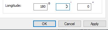
Yes, I tried it myself and the instructions are outdated. For step 2 create a feature class, in your case, a polygon feature class, then click next. On the screen to choose the coordinate system right click on WGS 1984 and choose copy and modify. On the window that opens set the Longitude to 180.
Then finish the remaining steps as needed. Start editing on the new layer and copy your Russia boundary polygon into the new layer. Explode the polygon, then select all parts and merge back together. You will need to edit out the slight sliver that remains, but it should be straightforward as you are no longer editing across the dividing line.
I hope this helps.
- Mark as New
- Bookmark
- Subscribe
- Mute
- Subscribe to RSS Feed
- Permalink
- Report Inappropriate Content
I'm getting this error from ArcMap when attempting to explode.
