- Home
- :
- All Communities
- :
- Products
- :
- ArcGIS Pro
- :
- ArcGIS Pro Questions
- :
- Re: hide/mask features dynamically using Spatial M...
- Subscribe to RSS Feed
- Mark Topic as New
- Mark Topic as Read
- Float this Topic for Current User
- Bookmark
- Subscribe
- Mute
- Printer Friendly Page
hide/mask features dynamically using Spatial Map Series in ArcGIS Pro
- Mark as New
- Bookmark
- Subscribe
- Mute
- Subscribe to RSS Feed
- Permalink
I would like to use
-> the Spatial Map Series function to create 80 maps based on their spatial extent indicated by the boundary of the polygon
- I have an attribute table of 80 rows, each showing one polygon for an area
- I like to create a map series of 80 single maps showing only one area/boundary extent
- I don't like to see any other information outside this polygon - only the inside information is relevant
I am using Spatial Map Series, a mask layer and the Page Query in the layer properties.
Results: The map series works well and the 80 maps were created. Unfortunately I can see data outside the boundary/area even when I use the Page Query filter.
Any idea what I am doing wrong?
Thank you.
Solved! Go to Solution.
- Mark as New
- Bookmark
- Subscribe
- Mute
- Subscribe to RSS Feed
- Permalink
Hi Brigitte,
For each map in your map series, are you trying to exclude only the other 79 polygons? Or are you trying to exclude data from other layers too (excluding the imagery/basemap)?
If you're just trying to exclude the other 79 polygons, this can be done using a Page Query. Your data will need a field containing a unique identifier. When you create the map series, set this field as the 'Name Field' for the index layer. Then in the map layer Properties -> Page Query, set the field here too and set to 'Match'. This should then hide any features where the ID doesn't match, i.e. all other rows (since the IDs are unique).
If you want to hide data from other layers, then when creating the map series, under Map Extent, select 'Clip to index feature'. This will make the outside area white. Then go back to the map -> Properties -> Clip Layers, and exclude your imagery/basemap layer from clipping. This will allow the basemap to be viewed outside your polygon, but all other layers won't be visible outside your polygon.
Tim
- Mark as New
- Bookmark
- Subscribe
- Mute
- Subscribe to RSS Feed
- Permalink
Hi Tim,
Yes, this is what I was trying to do. Problem is, when I use the pulldown menu to select the layer I want to exclude for clipping (the imagery background layer, instead of a white background) I only get an empty list. No other layers are listed here.
Now my question. I use layer from the portal, meaning web maps and feature layers. I don't use feature class layers or shp files. Could this be the issues here? It seems to easy to just select this layer to be excluded, but for whatever reason the list is empty.
Any idea why this is the case, please?
- Mark as New
- Bookmark
- Subscribe
- Mute
- Subscribe to RSS Feed
- Permalink
Hi Brigitte, I just tested and it does allow me to exclude Portal layers. I'm using v3.0, so maybe your earlier version of Pro is operating a bit differently?
Just to confirm, after creating the series and selecting 'clip to index feature', when you go to the Map Properties -> Clip Layers, at the top it should say 'Clip to current map series index feature' and there should be an image of one of your 80 regions. Then drop down 'Exclude layers from clipping', all the map layers should be listed with tick boxes available. If the top section looks right but the drop down menu is blank then I'd say your version of Pro is not operating properly for you?
- Mark as New
- Bookmark
- Subscribe
- Mute
- Subscribe to RSS Feed
- Permalink
Hi Toyota,
Thanks for your assistance. All the tips you gave helped me to narrow down the problem. The problem was not my Pro version, the problem was I was using web maps and feature layers (exported from web maps). If I used any "web"-format the pull down menu was empty and layers could not be excluded. As soon as I exported the web maps to feature layers and added to the Desktop version I exported the feature from the feature layers to create feature classes in the gdb. Once this was done for ALL layers listed in the TOC then I could select layers excluded form the clipping to extent option in the Map Series dialog.
To sum up: web map and feature layers can not be used when you want to select single layers that should be excluded to the clipped extent. This was definitely a new learning for me. But now I have a nice automated Map Series showing all the things I wanted.
- Mark as New
- Bookmark
- Subscribe
- Mute
- Subscribe to RSS Feed
- Permalink
Hi Aubri,
Thanks for your support and the link to the UC. 🙂 Yes, this was very helpful.
But it doesn't help me in my issue.
When I use the pulldown menu to select the layer I want to exclude for clipping (the imagery background layer, instead of a white background) I only get an empty list. No other layers are listed here.
Now my question. I use layer from the portal, meaning web maps and feature layers. I don't use feature class layers or shp files. Could this be the issues here?
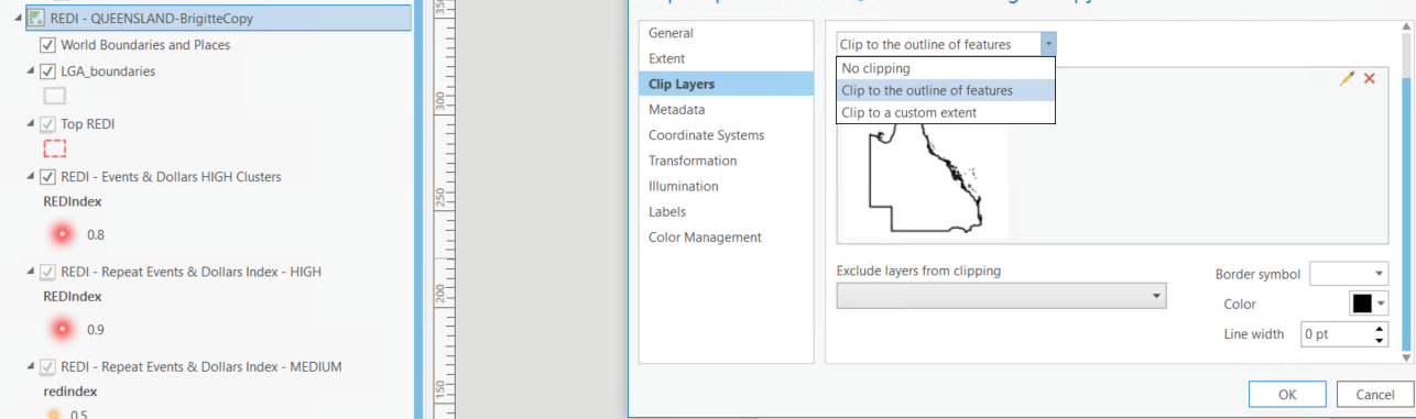
Here in the screenshot you can see that I have three options for clipping at the top and the layer I want to use for the spatial extent (map frame). The Exclude layer from clipping is empty.
This is the case in both approaches.
First approach start with the map, select clip to outline of feature - exclude is empty.
In the second approach where I go the the map series, specify my layer attributes for the extent, enable Clip within the Map Series dialog, go back the my map and then try to exclude the imagery/background layer.
Any idea why this is the case, please?
- Mark as New
- Bookmark
- Subscribe
- Mute
- Subscribe to RSS Feed
- Permalink
Ah I see now. The exclude layer is empty until you choose which layers to exclude. By default all layers are clipped. You have to manually select which layers you want to exclude from the exclude dropdown. In your picture you are looking at the clip type dropdown, not the exclude dropdown. In the exclude dropdown all the layers are listed and you can check them to exclude them. Once they are checked they'll appear in the dropdown list.

Aubri
- Mark as New
- Bookmark
- Subscribe
- Mute
- Subscribe to RSS Feed
- Permalink
Hi Aubri,
Thanks for your assistance. All the tips you gave helped me to narrow down the problem. The problem was not my ArcGIS Pro version, the problem was I was using web maps and feature layers (exported from web maps). If I used any "web"- format the pull down menu was empty and layers could not be excluded. As soon as I exported the web maps to feature layers and added to the Desktop version I exported the features from the web feature layers to new create feature classes in a new gdb. Once this was done for ALL layers listed in the TOC I could then select the layers to be excluded from the clipping to extent option in the Map Series dialog.
To sum up: web maps and feature layers can not be used when you want to select single layers that should be excluded to the clipped extent. This was definitely a new learning for me. But now I have a nice automated Map Series showing all the things I wanted.
- « Previous
-
- 1
- 2
- Next »
- « Previous
-
- 1
- 2
- Next »