- Home
- :
- All Communities
- :
- Products
- :
- ArcGIS Pro
- :
- ArcGIS Pro Questions
- :
- Re: Help with Geocoding Format
- Subscribe to RSS Feed
- Mark Topic as New
- Mark Topic as Read
- Float this Topic for Current User
- Bookmark
- Subscribe
- Mute
- Printer Friendly Page
Help with Geocoding Format
- Mark as New
- Bookmark
- Subscribe
- Mute
- Subscribe to RSS Feed
- Permalink
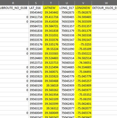
I have a .csv which I am trying to geocode in Pro. The rows I highlighted are the formatted cells. The columns to the left of each highlighted column is the original format.
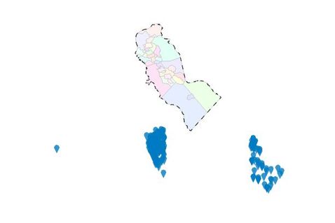
I brought the table into Pro, and tried to display the XY data on the newly formatted cells, and the points do not land within our County (and they are supposed to). I confirmed the coordinate system is the same as the map.
Below is a screenshot of how off the points geocoded.
I tried changing the coordinate system, and that did not help.
Any suggestions? I need this data to geocode correctly to do some analysis.
- Mark as New
- Bookmark
- Subscribe
- Mute
- Subscribe to RSS Feed
- Permalink
Sometimes Pro doesn't handle (csv) tables as expected, have you checked whether the coordinates in the Pro table match the ones in your original csv file?
- Mark as New
- Bookmark
- Subscribe
- Mute
- Subscribe to RSS Feed
- Permalink
I always use CSV tables to display the XY data and have not encountered an issue until now.
Yes, they do match. The only thing is the additional 0s dropped off at the end of some cells. But that shouldn't create an issue since it is 0 and not another number.
- Mark as New
- Bookmark
- Subscribe
- Mute
- Subscribe to RSS Feed
- Permalink
is there a chance that the coordinates prior to conversion represented degrees, minutes, decimal seconds?
Convert Coordinate Notation (Data Management)—ArcGIS Pro | Documentation
... sort of retired...
- Mark as New
- Bookmark
- Subscribe
- Mute
- Subscribe to RSS Feed
- Permalink
The spreadsheet is not ours, so I wouldn't have that information. It is data from the National Bridge Inventory.
- Mark as New
- Bookmark
- Subscribe
- Mute
- Subscribe to RSS Feed
- Permalink
Columns S and U are strange... are those weirdly formatted lat and longs? Normally if I had values like those I would assume they are decimal degrees and I would need to do a conversion to get them into Lat and Long.
- Mark as New
- Bookmark
- Subscribe
- Mute
- Subscribe to RSS Feed
- Permalink
You can see in the screenshot that I did format them - in the highlighted columns. You can see the difference there.
- Mark as New
- Bookmark
- Subscribe
- Mute
- Subscribe to RSS Feed
- Permalink
34.XX YY ZZZ you said the last 0 was dropped off
XX never goes above 59
YY never goes above 59
ZZZ any numbercould just be a strange coincidence but I got thinkin Degrees Decimal minutes 34 59.123
worth a check.
Also, what is the approximate distance that they are off?
... sort of retired...
- Mark as New
- Bookmark
- Subscribe
- Mute
- Subscribe to RSS Feed
- Permalink
That's great to know, thank you. I'm unfamiliar with the breakdown of the format so this is good information. I just did a quick scroll and confirmed that the XX and YY numbers do not go above 59. The points are anywhere between 7 and 20 miles off of where they should be.
- Mark as New
- Bookmark
- Subscribe
- Mute
- Subscribe to RSS Feed
- Permalink
Unrelated to the positional error but you can add the National Bridge Inventory from ArcGIS Online to your ArcGIS Pro project by going to the Catalog Pane->click the cloud>search for National Bridge Inventory and add it as a web layer to your map. See graphic below.


