- Home
- :
- All Communities
- :
- Products
- :
- ArcGIS Pro
- :
- ArcGIS Pro Questions
- :
- Find X,Y Coordinates
- Subscribe to RSS Feed
- Mark Topic as New
- Mark Topic as Read
- Float this Topic for Current User
- Bookmark
- Subscribe
- Mute
- Printer Friendly Page
- Mark as New
- Bookmark
- Subscribe
- Mute
- Subscribe to RSS Feed
- Permalink
I need to locate a bunch of points off a known point. My known point being 0,0. Like 23 feet in the X direction and 45 feet in the Y direction. How can I do this in ArcGIS Pro 2.2.4?
Solved! Go to Solution.
Accepted Solutions
- Mark as New
- Bookmark
- Subscribe
- Mute
- Subscribe to RSS Feed
- Permalink
To achieve the above in a manual way you can duplicate the layer in the map and setting two whereclauses to the layers. One to only show the feature with FID 92:

and the other to show the other you mentioned:

Next would be to use the Near Table to determine the distances of all the points (91 to 113 without 92) to point 92:
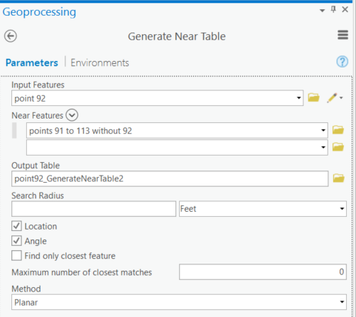
The resulting table will have the information to calculate the OffsetX and OffsetY:

Next you can join the Near Table to the point featureclass (the one that shows FID 91 to 113 without 92)
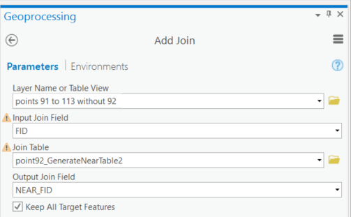
And then fill the OffsetX and OffsetY fields with the values from the joined table:
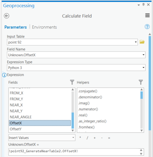
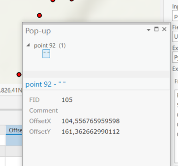
After that you will have the appropriate values in the fields:
- Mark as New
- Bookmark
- Subscribe
- Mute
- Subscribe to RSS Feed
- Permalink
If you have these measures in a table, you could calculate the new X and Y coordinates with 2 field calculations and simply use display XY to create a featureclass of these locations.
- Mark as New
- Bookmark
- Subscribe
- Mute
- Subscribe to RSS Feed
- Permalink
I already have all of the points in a feature class. I just need to find x,y coordinates of their locations from a specific point(Known Base Point). That make sense?
- Mark as New
- Bookmark
- Subscribe
- Mute
- Subscribe to RSS Feed
- Permalink
Do you ant to overwrite the point locations or create a new featureclass with the calculated locations? Do you have a sample of your data that you can share? It would make it easier to understand.
- Mark as New
- Bookmark
- Subscribe
- Mute
- Subscribe to RSS Feed
- Permalink
Full disclosure, I'm a newbie at this. I have reread your(Xander Bakker) comment about the field calculations several times and I think I finally understand. Are you saying to use the XY coordinates of a know point and subtract them from the other points to get the difference? Thus giving me the distance between the point? If so that should work. So then I just need to convert the XY coordinate to Feet. Don't suppose you know of an easy way to do that?
- Mark as New
- Bookmark
- Subscribe
- Mute
- Subscribe to RSS Feed
- Permalink
So as far as I see there are two options:
- In case you want to update/overwrite the existing locations of the points by moving the points using the movements in X and Y directions
- You want to create an additional featureclass based on the first featureclass, where each point is moved using the movements in X and Y directions
Both can be valid options. If you could share a sample of your data that would help to understand what you have.
- Mark as New
- Bookmark
- Subscribe
- Mute
- Subscribe to RSS Feed
- Permalink
I'm looking at the data and I am starting to understand something quite different. You have the fields OffsetX and OffsetY and the group of features with FID 91 to 113. The Offset fields are empty.
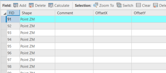
It looks like you want to fill the Offset field with the X and Y distances from your reference point with FID 92:
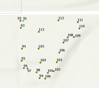
Is that what you want?
- Mark as New
- Bookmark
- Subscribe
- Mute
- Subscribe to RSS Feed
- Permalink
To achieve the above in a manual way you can duplicate the layer in the map and setting two whereclauses to the layers. One to only show the feature with FID 92:

and the other to show the other you mentioned:

Next would be to use the Near Table to determine the distances of all the points (91 to 113 without 92) to point 92:

The resulting table will have the information to calculate the OffsetX and OffsetY:

Next you can join the Near Table to the point featureclass (the one that shows FID 91 to 113 without 92)

And then fill the OffsetX and OffsetY fields with the values from the joined table:

After that you will have the appropriate values in the fields:

- Mark as New
- Bookmark
- Subscribe
- Mute
- Subscribe to RSS Feed
- Permalink
That is exactly what I'm looking for. Thank you. One problem though, I don't have access to the Generate Near Table (Tool is not licensed) Bummer! Oh well. Thank you for looking into this for me.