- Home
- :
- All Communities
- :
- Products
- :
- ArcGIS Pro
- :
- ArcGIS Pro Questions
- :
- Re: extrapolation
- Subscribe to RSS Feed
- Mark Topic as New
- Mark Topic as Read
- Float this Topic for Current User
- Bookmark
- Subscribe
- Mute
- Printer Friendly Page
extrapolation
- Mark as New
- Bookmark
- Subscribe
- Mute
- Subscribe to RSS Feed
- Permalink
hi every one,I'm trying to extrapolation my spatial data to larger area, but I don't know if its possible and which tool can.
I m working with pollution concentrations ,its follow a specific spatial trend
thanks
- Mark as New
- Bookmark
- Subscribe
- Mute
- Subscribe to RSS Feed
- Permalink
Can you elaborate a little more on what type of data you have, the current extent of the data and how far you would like to extrapolate the data? Also do you have acces to the Geostatistical Analyst extension?
- Mark as New
- Bookmark
- Subscribe
- Mute
- Subscribe to RSS Feed
- Permalink
yes I have access to Geostatistical analysit extension,I have pollutant concentration of an area and I apply the EBK Regression Prediction method from Geostatistical wizard in Arcgis PRO using altitude raster as prediction variables.for the area i got very pretty result but I wanna to extrapolate for larger area.
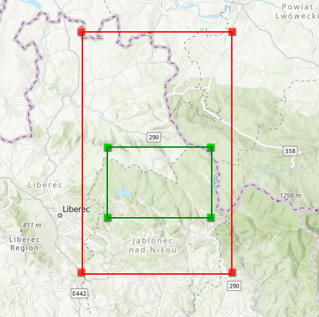
the current extent of the data
top :50.856194
bottom:50.767833
left:15.151972
right:15.357413 dd
and I like to extrapolate to
top :51
bottom:50.7
left:15.10
right:15.4
please note that I tried the extent tool but it s not activated in arcgis pro
- Mark as New
- Bookmark
- Subscribe
- Mute
- Subscribe to RSS Feed
- Permalink
Set your analysis extent to the larger extent prior to running the tool. In any event, extrapolation is generally a bad idea unless you are absolutely sure that trends seen at the edges persist beyond the margins
- Mark as New
- Bookmark
- Subscribe
- Mute
- Subscribe to RSS Feed
- Permalink
Yes I m sure that there is a trend it been demonstrate by prior studies in the field.
- Mark as New
- Bookmark
- Subscribe
- Mute
- Subscribe to RSS Feed
- Permalink
Just remember that it is a relatively large area that need to be covered by extrapolation. Without some additional information, like a trend or something that would enable Co-Kriging, your result will not be very accurate
- Mark as New
- Bookmark
- Subscribe
- Mute
- Subscribe to RSS Feed
- Permalink
thanks for your answer,but I how can I do the extrapolation which tool I must use
- Mark as New
- Bookmark
- Subscribe
- Mute
- Subscribe to RSS Feed
- Permalink
So, technically you can use extrapolate your data to a larger extent, as long as you follow the instructions provided by Dan (set the desired extent for your output in the Geoprocessing Environment). Which tool can you use? Probably any interpolation tool available in Spatial Analyst/3D Analyst and Geostatistical Analyst. Since you have Geostatistical Analyst, this is the preferred tool for the job. If you have any other information that has coverage for the entire area and there is a strong relationship between this data and your pollutant concentration, you would use this relation in Creating a prediction map using cokriging—Help | ArcGIS Desktop to create your map. Geostatistical Analyst is also preferred since it will create a probability map that will tell you more about the quality of your result. Expect lower quality the further you are from the area covered by your data.
Also have a look at: What are the different kriging models?—Help | ArcGIS Desktop
- Mark as New
- Bookmark
- Subscribe
- Mute
- Subscribe to RSS Feed
- Permalink
great thanks
- Mark as New
- Bookmark
- Subscribe
- Mute
- Subscribe to RSS Feed
- Permalink
yes I m trying to extent this to larger area but I coudnt do it in arcgis pro like I use to do in arcmap