- Home
- :
- All Communities
- :
- Products
- :
- ArcGIS Pro
- :
- ArcGIS Pro Questions
- :
- Exported PDFs have no layers
- Subscribe to RSS Feed
- Mark Topic as New
- Mark Topic as Read
- Float this Topic for Current User
- Bookmark
- Subscribe
- Mute
- Printer Friendly Page
- Mark as New
- Bookmark
- Subscribe
- Mute
- Subscribe to RSS Feed
- Permalink
Hello all. In ArcMap when exporting a layout the resulting PDF had layers of all the feature classes, text, and imagery.
While using ArcGIS Pro 2.0.2 and creating PDFs of layouts, regardless if I use the Print Layout (to the virtual Adobe PDF "printer") or Export Layout button, the PDFs have no layers.
Was wondering if that is just something ArcGIS Pro cannot do or if there is an option someplace that I am missing.
Thank you.
Solved! Go to Solution.
Accepted Solutions
- Mark as New
- Bookmark
- Subscribe
- Mute
- Subscribe to RSS Feed
- Permalink
http://pro.arcgis.com/en/pro-app/help/sharing/overview/export-a-map-or-layout.htm
# 10 you might have stopped scrolling too soon
Layers and attributes controls whether your PDF will contain layers like your map. Additionally, you can choose to include the attribute data from the features in the PDF. Be aware that including attributes for a large number of layers can affect the performance of the PDF.
- Mark as New
- Bookmark
- Subscribe
- Mute
- Subscribe to RSS Feed
- Permalink
You can definitely export a map or layout to pdf
http://pro.arcgis.com/en/pro-app/help/sharing/overview/export-a-map-or-layout.htm
You might want to provide more information on settings etc
- Mark as New
- Bookmark
- Subscribe
- Mute
- Subscribe to RSS Feed
- Permalink
Yes. Sorry if it wasn't clear.
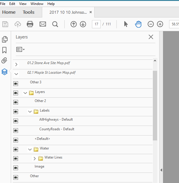
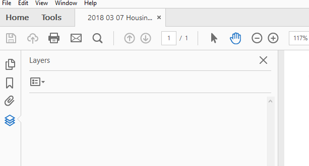
I can export layouts/maps in ArcGIS Pro to PDF without an issue. My problem is that that with ArcMap, an exported PDF would have layers of all the features and text of the map that a person could toggle on/off. The PDFs that are exported with ArcGIS Pro do no have these layers.
PDF Exported with ArcMap gives all these:
PDF Exported with ArcGIS Pro gives nothing
- Mark as New
- Bookmark
- Subscribe
- Mute
- Subscribe to RSS Feed
- Permalink
http://pro.arcgis.com/en/pro-app/help/sharing/overview/export-a-map-or-layout.htm
# 10 you might have stopped scrolling too soon
Layers and attributes controls whether your PDF will contain layers like your map. Additionally, you can choose to include the attribute data from the features in the PDF. Be aware that including attributes for a large number of layers can affect the performance of the PDF.
- Mark as New
- Bookmark
- Subscribe
- Mute
- Subscribe to RSS Feed
- Permalink
Yup. I guess all those options in section 10 didn't stand out to me. Thank you!
- Mark as New
- Bookmark
- Subscribe
- Mute
- Subscribe to RSS Feed
- Permalink
Hi JWos
You can manipulate layers of an exported file from Pro by using bluebeam instead of acrobat. The general menu contains a layers section where the visibility can turn on and off.
Hope, it solved the issue.

- Mark as New
- Bookmark
- Subscribe
- Mute
- Subscribe to RSS Feed
- Permalink
but why? why in the world would i not want to print what i see on my layout when i choose to share? if i don't want to see layers......... i turn them off. why is EVERYTHING so complicated with this program? I've spent hours upon hours trying to figure out things that should not even have to be considered. Like, for example, trying to print what is on my screen. A lot of thought has gone into making this program as complicated as possible. So frustrating.
- Mark as New
- Bookmark
- Subscribe
- Mute
- Subscribe to RSS Feed
- Permalink
you are not alone in your grief. I'd hoped moving from ArcMap to ArcGIS Pro would improve the UX and underlying functionality, but after a couple years of using it, I don't feel much improvement has been made.
For example, I can drag a georeferenced layered PDF into QGIS and it lets me select what layers I want to bring in as vector data, and they show up in the right place without needing to be georeferenced. Try that in ArcGIS Pro and the only improvement i see over ArcMap is that at least I don't have to convert it to a TIFF first, but vector layers are ignored and require something like FME to extract to bring in.
Currently my ability to export from ArcGIS Pro as a layered PDF is greyed out, and despite unchecking the accessibility tags option, I am still unable to get a PDF with layers to export. Searching help docs at Esri has been a goose chase leading nowhere productive.