- Home
- :
- All Communities
- :
- Products
- :
- ArcGIS Pro
- :
- ArcGIS Pro Questions
- :
- Error creating orthomapping workspace with histori...
- Subscribe to RSS Feed
- Mark Topic as New
- Mark Topic as Read
- Float this Topic for Current User
- Bookmark
- Subscribe
- Mute
- Printer Friendly Page
Error creating orthomapping workspace with historical air photos
- Mark as New
- Bookmark
- Subscribe
- Mute
- Subscribe to RSS Feed
- Permalink
Hello everyone,
I am hoping to get a bit of guidance on how to create a DSM from historical air photos using the Ortho Mapping functionality in ArcPro. My ArcPro version is 3.2.2.
A bit of background. I have a single stereopair of scanned air photos from the 1980's with sufficient overlap between both photos. The goal is to create a DSM from the photos to examine important landscape features in my study area. These photos have been manually georeferenced (as .tif files), and I do not require high accuracy (vertical or horizontal) as the output DSM will be largely to visually examine the general shape of such landscape features rather than perform any anaylsis with them.
Unfortunately, these two photos came with absolultey no ancillary information about image acquisition, rotation (exterior, interior), camera focal length, frame or camera tables, etc. We have contacted the provider and they simply have no other information to provide us. We have nothing but the images. I have created a Frames table by downloading the templates and estimating the parameters as per (Create an ortho mapping workspace for scanned aerial imagery—ArcGIS Pro | Documentation) and the Ortho Mapping tool seems to accept it.
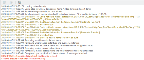
However, once the Ortho Mapping workspace is prepared and I click 'Finish' I get the following error.
I have looked through the tutorials below and searched for these specific errors but have found nothing that fixes the problem. The images have pyramids and statistics created, as some sources suggested. The 'Invalid Cell Size' error makes no sense because when I run the RasterInfo Function tool, it clearly shows a valid cell size (0.5 m) for these images. I'm at a lost and would love some direction. Given the complete lack of ancillary info, is creating a DSM from these photos even possible?
Preprocessing historical images—Imagery Workflows | Documentation (arcgis.com)
Working with Historical Scanned Film Imagery (esri.com)
Thanks in advance,
Nigel
