- Home
- :
- All Communities
- :
- Products
- :
- ArcGIS Pro
- :
- ArcGIS Pro Questions
- :
- Re: Dividing and Incorporating long coastal sliver...
- Subscribe to RSS Feed
- Mark Topic as New
- Mark Topic as Read
- Float this Topic for Current User
- Bookmark
- Subscribe
- Mute
- Printer Friendly Page
Dividing and Incorporating long coastal slivers into several neighbours
- Mark as New
- Bookmark
- Subscribe
- Mute
- Subscribe to RSS Feed
- Permalink
Hi, I have two boundary sets.
1. Census Enumeration Districts (EDs)
2. Polygons filling the space between the EDs and the official coastal boundary.
What I need to do is to extent the EDs to that coastline.
The job's 99% done, but some of the coastal slivers extend for several miles and as it stands, would be allocated to a single 'tadpole' ED. I need to break these slivers at ED boundaries.
What I am looking for is to:
- Select the vertex where two EDs meet the coastal sliver;
- Buffer that vertex until it hits the far side of the sliver;
- Create a new vertex there.
- Draw a line from the vertex at the centre of the buffer to the new vertex;
- Cut the sliver with the line;
- Dissolve the new sliver units into their proper ED.
Is this possible, please?
Many thanks
- Mark as New
- Bookmark
- Subscribe
- Mute
- Subscribe to RSS Feed
- Permalink
How many ED's and coastline polygons do you have that need fixing? Simplest manual way would be to append the coastline polygons into your ED layer, then use the split editing tool with snapping on to go along and split the coastline. Then select each pair and use the merge tool (making sure to select your ED polygon as the target the keep the attributes). Any automated solution will most likely introduce topology issues which you will have to go back and fix anyway. The question is then - how long will it take you do manually split\merge vs how long to find and fix the topology errors?
I don't think buffering will work, because it will have to find the exact buffer distance by trial and error to intersect the coastline at a single point (or 2 points with very small distance between them). As shown in your 4th slide, the computer can't tell that the buffer of the leftmost point is not correct.
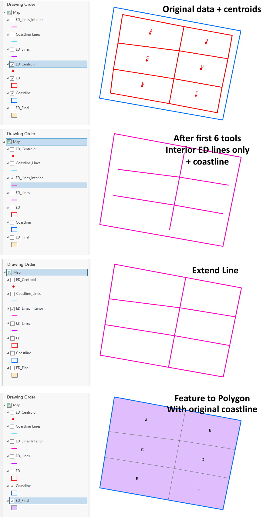
Here's an alternative way, getting just the interior ED lines and using the Extend Lines tool to extend them to the coastline. Extra steps to export centroids to help turn them back into polygons at the end. Input are ED polygons (ED) and the original Coastline polygon (Coastline). Below are all the geoprocessing tool steps. I have attached some screenshots as well.
- Feature To Point: Input Features ED, Output Feature Class ED_Centroid, Inside INSIDE
- Polygon To Line: Input Features ED, Output Feature Class ED_Lines, Identify and store polygon neighboring information IDENTIFY_NEIGHBORS
- Feature To Line: Input Features Coastline, Output Feature Class Coastline_Lines, Preserve attributes ATTRIBUTES
- Select Layer By Attribute: Input Rows ED_Lines, Selection type NEW_SELECTION, Expression LEFT_FID > -1
- Copy Features: Input Features ED_Lines, Output Feature Class ED_Lines_Interior
- Append: Input Datasets Coastline_Lines, Target Dataset ED_Lines_Interior, Field Matching Type NO_TEST
- Extend Line: Input Features ED_Lines_Interior, Extend Length 100 Meters, Extend to Extensions FEATURE
- Feature To Polygon: Input Features ED_Lines_Interior, Output Feature Class ED_Final, Preserve attributes ATTRIBUTES, Label Features ED_Centroid
Now, this may not work if the last segments of your ED lines are at large angles to the coastline, if they are generally perpendicular to, or pointing at, the coastline then it should be ok. The most likely issue is that the extended lines cross each other, which you would have to go back and fix.