- Home
- :
- All Communities
- :
- Products
- :
- ArcGIS Pro
- :
- ArcGIS Pro Questions
- :
- Display of geographical data in SAP Hana database ...
- Subscribe to RSS Feed
- Mark Topic as New
- Mark Topic as Read
- Float this Topic for Current User
- Bookmark
- Subscribe
- Mute
- Printer Friendly Page
Display of geographical data in SAP Hana database on the map in ArcGIS Pro environment
- Mark as New
- Bookmark
- Subscribe
- Mute
- Subscribe to RSS Feed
- Permalink
Hello,
We have a problem with the display of line and polygon data on the SAP Hana database. It was observed that line and polygon objects created with large angle difference can not be displayed in the drawing.
We have exported the data stored in the Oracle database to the SAP Hana database environment. I did this using Append tool. However, after the data is sent, it cannot displayed on the map. The objects have to be created many drawings at different angles like province, district, neighborhood are kept in the database.
However, after I use full extent operation on map, I found out that the drawings on the map can be displayed on a small scale like 1/20 million. But, making zoom in process on map, the recorded data is not displayed on the map again if zoomed in to map.
I thought that it could be because of extent or spatial index in sde database. So that's why I did many things.
The spatial indexes of the layers have been recalculated on Oracle geodatabase. I exported data to gdb environment, then again I did delete spatial index, create spatial index, recalculate spatial index operations again. I performed recalculate feature class extent tool in gdb and sde geodatabase. And I tried to change the extent of feature clas manually to get the desired result from this operation. And still dead end  . These procedures can't be performed in Sap Hana database. That's why there procedures performed outside of sap hana database.
After I create a new feature class in SAP Hana database, I performed drawings on feature class. It was still the same. I couldn't see objects on map in Arcgis Pro.
When a complicated drawing operation is performed on the new layer in the SAP Hana database, we have noticed that the new drawn object can not display the map either. The display in the shape-preserved WKT format has been examined. However, there was no error in the alignment of the coordinates.
I recorded a video of the errors. You can find the video link related to the subject from below:
https://we.tl/t-n3twqsjstl
You can find the screenshots below...
These editings are created on SAP Hana database by using Arcgis Pro:
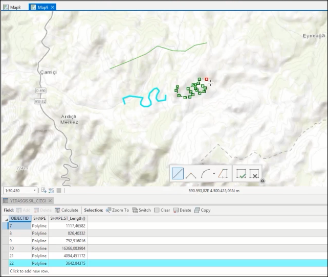
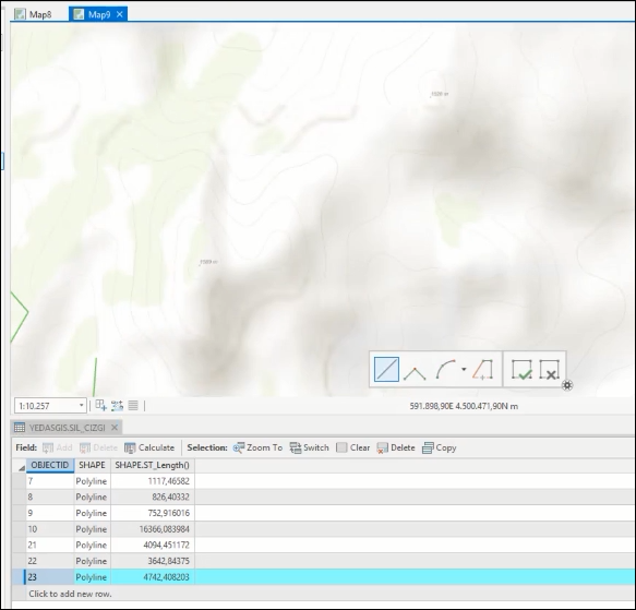
When zoom into line object, it cannot be displayed on map. But there is a record on database.
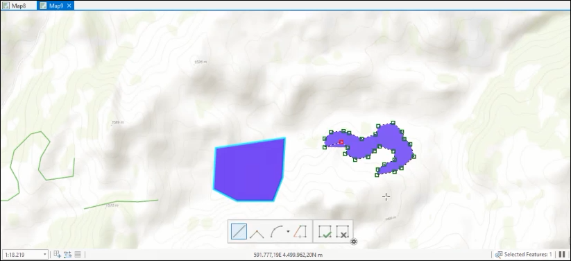
While editing polygon object:
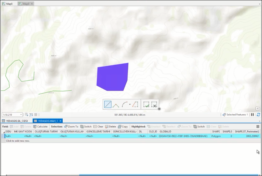
After editin polygon object, it can be only displayed on database.
- Mark as New
- Bookmark
- Subscribe
- Mute
- Subscribe to RSS Feed
- Permalink
On your poly line feature class, do you have anything set for the visibility range? Specifically for the 'In beyond' scale?
- Mark as New
- Bookmark
- Subscribe
- Mute
- Subscribe to RSS Feed
- Permalink
No, I didn't add any visibility range on feature class. I checked it again. There is no visibility range (in beyond or out beyond)
- Mark as New
- Bookmark
- Subscribe
- Mute
- Subscribe to RSS Feed
- Permalink
A few more things you can check then is to pull back the SRID and WKT from HANA and check to make sure it's in the correct projection and if the coordinates are converted properly during the append tool.
You can use a query layer from ArcGIS pro something like:
select OBJECTID, SHAPE, SHAPE.ST_SRID(), SHAPE.ST_ASWKT() from <your table>
and make sure the SRID and WKT is looking exactly as you expect. If everything looks the correct, then the data is all correct from the HANA side.
Perhaps then its a line thickness issue in ArcGIS pro (as it is not something stored on the HANA table side)?
- Mark as New
- Bookmark
- Subscribe
- Mute
- Subscribe to RSS Feed
- Permalink
I reviewed the data in Oracle and SAP Hana with ArcGIS Pro. The tables use the same projection system.
I have examined the layer tables in the same projection system in Oracle and SAP Hana database.
The following sql statements were used.
Oracle
SELECT OBJECTID, sde.st_srid(SHAPE), sde.st_astext(SHAPE) FROM <my table>
SAP Hana
SELECT OBJECTID, SHAPE.ST_SRID() ,SHAPE.ST_asWKT() FROM <my table>
The WKT information is the same.
When I used sql statement in SAP Hana, I saw differences between the information I received with SHAPE.ST_SRID () and the information I received in the sde.st_srid(SHAPE) I used in Oracle.
I created an empty table on the SAP Hana database. I used the projection system I used in the Oracle database. I checked WKTIDs.
When I entered data in the SAP HANA database, I saw that the object gave a different number in the SHAPE.SRID part.
When I query SQL statement in database, I get the information SHAPE.ST_SRID () = 300000 in sql result.
So...could SAP Hana might hold certain SRID codes? Or It could might because of the projection system that I set. Or maybe it choose default SRID number for SAP HANA? I couldn't understand.
- Mark as New
- Bookmark
- Subscribe
- Mute
- Subscribe to RSS Feed
- Permalink
From my past observations, an SRID of 300000+ is something that ESRI will create in the HANA system to reflect the projection and transformation if that reference is not already available in your HANA system.
If you run
SELECT * from ST_SPATIAL_REFERENCE_SYSTEMS where SRS_ID=300000
you should be able to check to make sure the definition, extent and UOM are correct for the data you are using.
There are also a few thousand more SRS that can be installed on your HANA System from
- Mark as New
- Bookmark
- Subscribe
- Mute
- Subscribe to RSS Feed
- Permalink
Also look at this doc: Supported database management systems—Help | ArcGIS Desktop