- Home
- :
- All Communities
- :
- Products
- :
- ArcGIS Pro
- :
- ArcGIS Pro Questions
- :
- Re: Custom Map Frame for Layout
- Subscribe to RSS Feed
- Mark Topic as New
- Mark Topic as Read
- Float this Topic for Current User
- Bookmark
- Subscribe
- Mute
- Printer Friendly Page
- Mark as New
- Bookmark
- Subscribe
- Mute
- Subscribe to RSS Feed
- Permalink
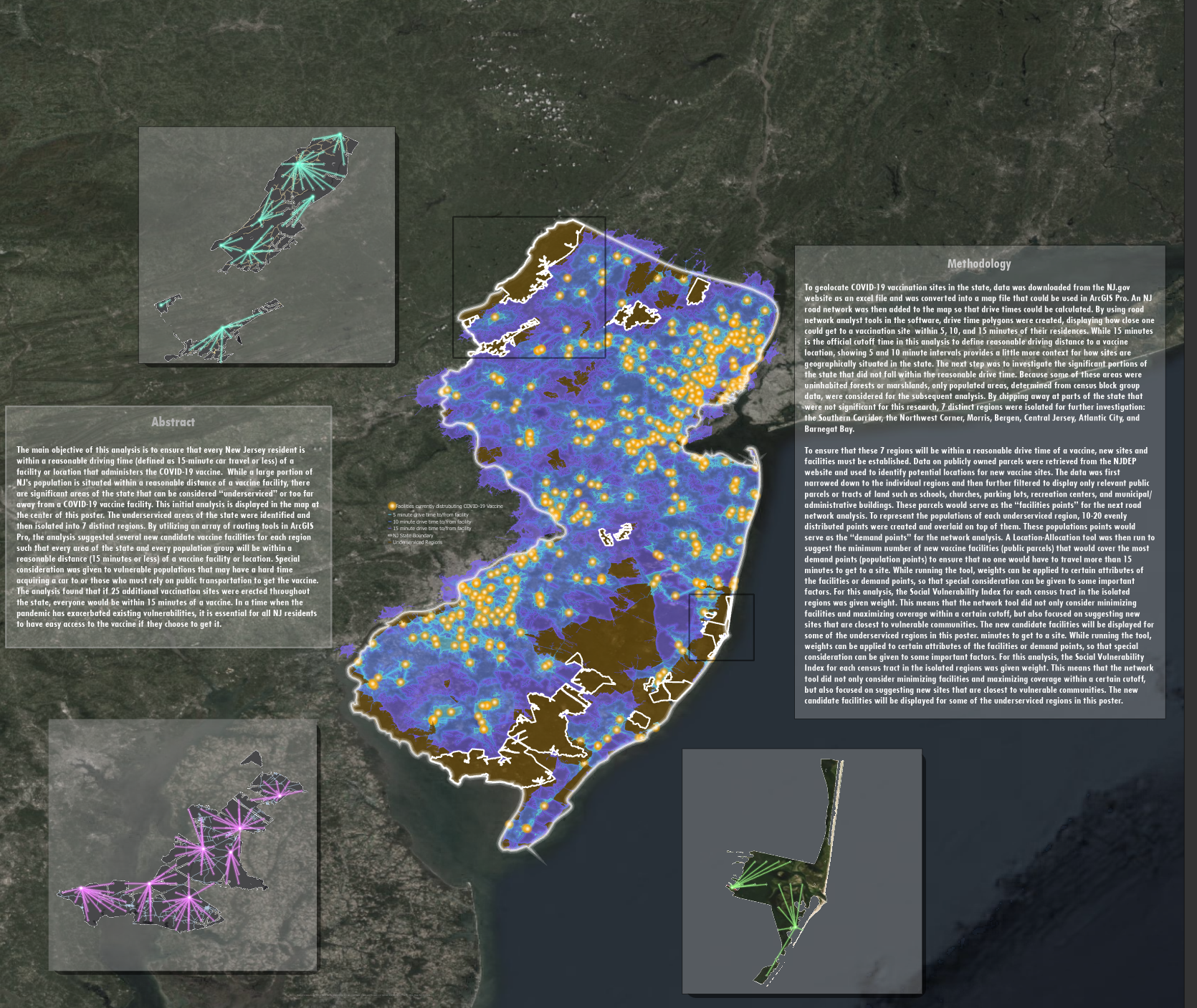
Is there a way to insert a custom shape map frame into a layout? I know there are options to make circular map frames and even polygons, but I would have to draw the polygon and then insert my map into it. I've clipped my maps to specific polygons and I want the map frame to be the same shape as the polygon so I'm not left with huge empty spaces in my map frame. I've included a photo of my layout with the current rectangular map frames and it looks fine, except when applying an extent indicator it shows the full extent of my map frame which is much bigger than the actual area of interest. It would be cool to have a map frame that's like the polygon in my map. Thanks!
Solved! Go to Solution.
Accepted Solutions
- Mark as New
- Bookmark
- Subscribe
- Mute
- Subscribe to RSS Feed
- Permalink
Hi Noam,
You can use feature geometry to "shape" the map frame by clipping the map. You would then use the border symbol of the clipped map as the border of the map frame by removing the map frame's border (set map frame border size to 0 or color to null in the Display tab of the map frame properties pane). This would give the impression of a "shaped" map frame even though the map frame is still a rectangle.
However, this only gets half way. Outside of a map series there is no way I know of to use feature geometry to shape an extent indicator. For a static map I agree with Dan's suggestion.
Hope this helps,
Tom
- Mark as New
- Bookmark
- Subscribe
- Mute
- Subscribe to RSS Feed
- Permalink
perhaps make a separate layer with the shape(s) you want... buffer them by some distance and use those polygons for your map frame.
... sort of retired...
- Mark as New
- Bookmark
- Subscribe
- Mute
- Subscribe to RSS Feed
- Permalink
Thanks for your suggestions, I think thats the best option to make an extent indicator match the shape of the map
- Mark as New
- Bookmark
- Subscribe
- Mute
- Subscribe to RSS Feed
- Permalink
Hi Noam,
You can use feature geometry to "shape" the map frame by clipping the map. You would then use the border symbol of the clipped map as the border of the map frame by removing the map frame's border (set map frame border size to 0 or color to null in the Display tab of the map frame properties pane). This would give the impression of a "shaped" map frame even though the map frame is still a rectangle.
However, this only gets half way. Outside of a map series there is no way I know of to use feature geometry to shape an extent indicator. For a static map I agree with Dan's suggestion.
Hope this helps,
Tom
- Mark as New
- Bookmark
- Subscribe
- Mute
- Subscribe to RSS Feed
- Permalink
Hi Tom, thanks for responding so quickly,
I did exactly like that for the the smaller map frames in the layout. I initially made the background of the map frame 100% transparent so it would look like a shaped map frame, but I found that it got lost against the basemap of the poster. I guess it looks fine this way but would definitely be useful if there was a tool that allowed you to shape the map frame to the exact shape of the map so that you dont have to deal with large rectangles when editing the poster and moving things around. As for the extent indicator, I agree, the best option would just be to create a layer on the map showing the buffered outline of the polygons.
Thanks for your suggestions!