- Home
- :
- All Communities
- :
- Products
- :
- ArcGIS Pro
- :
- ArcGIS Pro Questions
- :
- Re: create points along line varying distances
- Subscribe to RSS Feed
- Mark Topic as New
- Mark Topic as Read
- Float this Topic for Current User
- Bookmark
- Subscribe
- Mute
- Printer Friendly Page
create points along line varying distances
- Mark as New
- Bookmark
- Subscribe
- Mute
- Subscribe to RSS Feed
- Permalink
Hi,
I am trying to make a python script that will do the equivalent to that of selecting a point feature editing this and creating "Points along line" with "Varying Distances".
This will give a menu like this one:
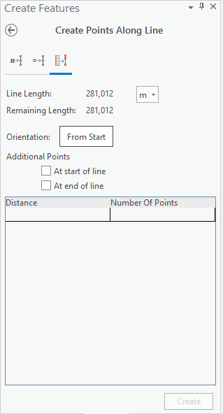
Where you will have to plot the distances manually. The next row will indicate the distance relative to the previous point.
I have a lot of points I'd like to plot in and therefore I want the stuff to go automatically.
So far I've had a look into using something like this:
>>> arcpy.GeneratePointsAlongLines_management(line2choose,"pntsAlongLine","DISTANCE",[10,20,10])
The list i've made at the end obviously won't work.
I've also had a look to the possibility of importing an excel file with the ID and Distance columns and creating points from this. If arcpy has a function to add a single point along a line with a specific distance from start I could do a loop and generate all the points from the imported table. So far I haven't found such a function.
Br,
Haakon Haugerud
- Mark as New
- Bookmark
- Subscribe
- Mute
- Subscribe to RSS Feed
- Permalink
Hi,
It would be a neat enhancement for the Create Points Along Lines and the Offset editing tools (both found on the Edit ribbon > Modify features pane) to be able to import distance values from a file - currently not possible. However, have you tried the Linear Referencing toolbox (Analysis tab > Tools > look for Linear Referencing Tools). I think the only two geoprocessing tools you would need are Create Routes and Make Route Event Layer.
An overview of the Linear Referencing toolbox—Help | ArcGIS Desktop
These two tutorials are written for ArcMap, but show how to use the above geoprocessing tools:
Exercise 2: Creating and calibrating route data—Help | ArcGIS Desktop
Exercise 4: Displaying and querying route events—Help | ArcGIS Desktop
Hope this helps!
Scott
- Mark as New
- Bookmark
- Subscribe
- Mute
- Subscribe to RSS Feed
- Permalink
Thanks Scott.
I am trying to use the Linear Referencing tools now, but have a question.
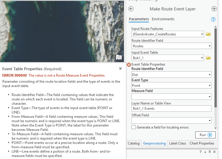
Right now I am trying to make a Route Event Layer with my Route and an input event table. But I got the error that "ERROR 000840 The value is not a Route Measure Event properties". Trying to find a way to choose that the Field is a route event field, but I am having problems.
- Mark as New
- Bookmark
- Subscribe
- Mute
- Subscribe to RSS Feed
- Permalink
I'm not sure about why that could be, but a quick search on Geonet reveals someone who found a solution for their specific case:
https://community.esri.com/thread/101652#comment-658022
If that doesn't work, maybe a quick call to Esri Technical Support will help? - Esri Support Contact Support
- Mark as New
- Bookmark
- Subscribe
- Mute
- Subscribe to RSS Feed
- Permalink
Hi,
I am wondering, you had any luck in figuring that out? I also need to create thousands of points along the line at varying (known) distances but unable to find any way of doing that.
- Mark as New
- Bookmark
- Subscribe
- Mute
- Subscribe to RSS Feed
- Permalink
Looks like your Route Identifier Field was pointed at a Distance value in attributes of the original polyline used to create the route. It needs to point to a unique route ID that is common to the entire polyline *and* the table of distances you'll use when you display route events. So if you add routeID as an attribute of the polyline before you turn it into a route, and then use that same routeID as an attribute of your table of distances, the two will work together nicely.
If you have a table with the distances down the line in it, you don't need to enter them manually using Create Points Along Line tool.
Create a route from your polyline - https://pro.arcgis.com/en/pro-app/2.9/tool-reference/linear-referencing/create-routes.htm (you'll need to add an attribute for route identifier)
Then add events to your route using that table of distances down the line - https://pro.arcgis.com/en/pro-app/2.9/help/data/linear-referencing/display-route-events.htm (you'll need to include the same attribute value for route identifier that your used on the polyline that you turned into a route in the previous step)
You can take the resulting events layer and export them as points along the polyline.
I know this is a really late response, but I searched for a long time trying to find out how to do this in a way other than entering each point distance one at a time...
- Mark as New
- Bookmark
- Subscribe
- Mute
- Subscribe to RSS Feed
- Permalink
Hi all:
I am in the same position as well.
I need to make a point feature class along a line with varying and known distances but unable to find a way to do that. I have also tried using similar approach mentioned a the beginning of this thread and did not make any progress.
Any suggestions please?
- Mark as New
- Bookmark
- Subscribe
- Mute
- Subscribe to RSS Feed
- Permalink
Hi,
did you got a solution?
Thanks
- Mark as New
- Bookmark
- Subscribe
- Mute
- Subscribe to RSS Feed
- Permalink
import arcpy
# Set up environment settings
arcpy.env.workspace = r"C:\Your\Workspace" # Set your workspace path here
arcpy.env.overwriteOutput = True
# Input polyline feature class
input_polyline = "your_polyline.shp" # Change to your input polyline shapefile
# Output point feature class
output_points = "points_along_polyline.shp" # Change to your desired output point shapefile
# Table containing distances along the line
distance_table = "distance_table.dbf" # Change to the path of your distance table
# Field in the distance table containing the distances
distance_field = "Distance" # Change to the name of your distance field
# Create an empty list to hold point geometries
point_geometries = []
# Iterate through the table and create points at the specified distances
with arcpy.da.SearchCursor(distance_table, [distance_field]) as cursor:
for row in cursor:
distance = row[0]
with arcpy.da.SearchCursor(input_polyline, ["SHAPE@"]) as polyline_cursor:
for polyline_row in polyline_cursor:
polyline = polyline_row[0]
if distance <= polyline.length:
point = polyline.positionAlongLine(distance)
point_geometries.append(point)
# Create a new point feature class and add point geometries
arcpy.CopyFeatures_management(point_geometries, output_points)
print("Points created along the polyline using distances from the table.")
This should work if you want to add points along a polyline by referencing an existing table with all of your distance values. If not, you can copy and paste your values in the following:
import arcpy
# Set up environment settings
arcpy.env.workspace = r"C:\Your\Workspace" # Set your workspace path here
arcpy.env.overwriteOutput = True
# Input polyline feature class
input_polyline = "your_polyline.shp" # Change to your input polyline shapefile
# Output point feature class
output_points = "points_along_polyline.shp" # Change to your desired output point shapefile
# List of distances along the line where you want to place points
distances = [50, 100, 200, 300, 500] # Modify as needed
# Create an empty list to hold point geometries
point_geometries = []
# Iterate through the vertices of the polyline and create points at the specified distances
with arcpy.da.SearchCursor(input_polyline, ["SHAPE@"]) as cursor:
for row in cursor:
polyline = row[0]
for distance in distances:
if distance <= polyline.length:
point = polyline.positionAlongLine(distance)
point_geometries.append(point)
# Create a new point feature class and add point geometries
arcpy.CopyFeatures_management(point_geometries, output_points)
print("Points created along the polyline at varying distances.")
I hope this helps!
- Mark as New
- Bookmark
- Subscribe
- Mute
- Subscribe to RSS Feed
- Permalink
Hello,
I realize this is a late response, but I had a similar issue recently in ArcGIS Pro 3.4 and 3.3.
I realized that once I added the 'Measure Field' parameter in, the warning about the Route Identifier Field was removed.
However, the tool would run and fail with the error "000211: Cannot create route event source."
I was able to resolve the error after I realized the input for the 'Measure Field' parameter I was using was a text field and the tool requires the parameter use a numeric field as indicated here -> https://pro.arcgis.com/en/pro-app/latest/tool-reference/linear-referencing/make-route-event-layer.ht....
After creating a new numeric field and populating with the information from the original text field, the tool ran successfully and created the points along my route.
Hope this helps!
Support Analyst