- Home
- :
- All Communities
- :
- Products
- :
- ArcGIS Pro
- :
- ArcGIS Pro Questions
- :
- Re: Converting floating raster to integer is faili...
- Subscribe to RSS Feed
- Mark Topic as New
- Mark Topic as Read
- Float this Topic for Current User
- Bookmark
- Subscribe
- Mute
- Printer Friendly Page
Converting floating raster to integer is failing
- Mark as New
- Bookmark
- Subscribe
- Mute
- Subscribe to RSS Feed
- Permalink
I'm trying to convert a 32 bit floating raster into an integer type using the 'int' spatial analyst tool within ArcGIS Pro (2.8.3).
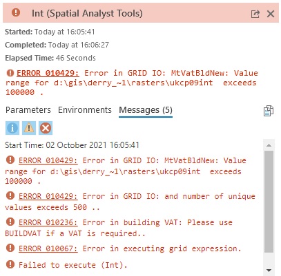
I have used the raster calculator to remove the decimals (in my case, multiplying by 100,000 as there are 5 decimal places - e.g. 7.10105 converted to 710,105). However, when I then attempt the int run I get the following error: "ERROR 010429: Error in GRID IO: MtVatBldNew: Value range for d:\gis\derry_~1\rasters\derryukcint2 exceeds 100000." I have attached a screenshot of the full error messages.
I am using an external hard drive with 350GB of space available, and cannot see anything to suggest that the raster is corrupted. Any help is greatly appreciated!
Solved! Go to Solution.
Accepted Solutions
- Mark as New
- Bookmark
- Subscribe
- Mute
- Subscribe to RSS Feed
- Permalink
You say you exported the original as a tif? My meaning was more to set .tif as the extension of the output raster in the int tool (outside a geodatabase).
Are you able to share your input parameters to the tool and the error when you try to save the int output as a tiff?
curtvprice's suggestion about filename and filepath (including the names of higher level directories) should also be checked.
- Mark as New
- Bookmark
- Subscribe
- Mute
- Subscribe to RSS Feed
- Permalink
Those errors seem to be associated with locks in some cases, so possibly something to look into, full restart, check locks on SDE etc.
Unsure why it would error on not building a VAT, thought that would be a warning or info message at most.
Can you do a tiff? 🙂
- Mark as New
- Bookmark
- Subscribe
- Mute
- Subscribe to RSS Feed
- Permalink
Thank you for your suggestions! Can't find any locks on SDE, and just tried exporting as .tif and rerunning, but it is still coming back with the same error sadly.
- Mark as New
- Bookmark
- Subscribe
- Mute
- Subscribe to RSS Feed
- Permalink
With a raster with many many unique values you often expect those other messages to appear as warnings. My guess is the other errors would have been warnings, but the last one actually triggered the error condition for all messages.
It looks like you are writing to Esri grid format, which is the least flexible with pathnames, when writing to a folder that even has a space it can sometimes fail.
I second the suggestion to try writing to .tif format, which is generally the fastest and most robust raster format. I would also verify your resources on the computer you are writing too (disk space, permissions) as these can cause really strange errors.
- Mark as New
- Bookmark
- Subscribe
- Mute
- Subscribe to RSS Feed
- Permalink
Thanks so much for the suggestions! I was using ESRI grid format – I just exported it as .tif and reran the int tool again but unfortunately getting the same error.
I have used the same steps to convert from floating to integer type in other case study areas but two specific sites are not working. I have 28GB storage available on my PC and no issues with permissions, so really unsure of what is causing the error!
- Mark as New
- Bookmark
- Subscribe
- Mute
- Subscribe to RSS Feed
- Permalink
You say you exported the original as a tif? My meaning was more to set .tif as the extension of the output raster in the int tool (outside a geodatabase).
Are you able to share your input parameters to the tool and the error when you try to save the int output as a tiff?
curtvprice's suggestion about filename and filepath (including the names of higher level directories) should also be checked.
- Mark as New
- Bookmark
- Subscribe
- Mute
- Subscribe to RSS Feed
- Permalink
Sorry my mistake - I misunderstood! I tried setting .tif as the extension in the int tool just now and it worked - thank you so much!!
- Mark as New
- Bookmark
- Subscribe
- Mute
- Subscribe to RSS Feed
- Permalink
...for the record. What is the size of the output raster, i.e. number of columns and rows and how many records in the attribute table?
- Mark as New
- Bookmark
- Subscribe
- Mute
- Subscribe to RSS Feed
- Permalink
The output raster has 22,000 columns and 33,000 rows, and when converted to a polygon there are 12,511,883 records in the attribute table. I used the steps recommended by my supervisor, but I realise now I probably should have extracted depth bands using the raster calculator before attempting to convert into a polygon! I'll be sure to do this in future and hopefully the process will be a lot quicker and easier.
- Mark as New
- Bookmark
- Subscribe
- Mute
- Subscribe to RSS Feed
- Permalink