- Home
- :
- All Communities
- :
- Products
- :
- ArcGIS Pro
- :
- ArcGIS Pro Questions
- :
- Change the draw order of graticule grids in ArcGIS...
- Subscribe to RSS Feed
- Mark Topic as New
- Mark Topic as Read
- Float this Topic for Current User
- Bookmark
- Subscribe
- Mute
- Printer Friendly Page
Change the draw order of graticule grids in ArcGIS Pro layout view?
- Mark as New
- Bookmark
- Subscribe
- Mute
- Subscribe to RSS Feed
- Permalink
How do I change the draw order placement for a graticule grid in layout view?
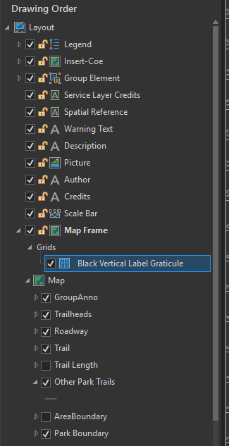
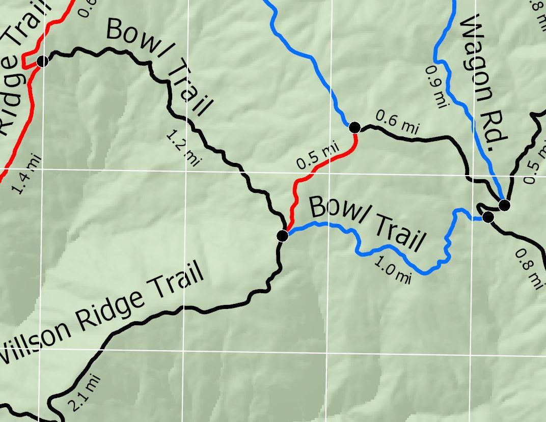
I am working on a trail map for a school project. When I add a graticule grid to the layout, the grid draws over the other elements of the layout (see "map cropped.jpg"). I am not finding a way of moving the grid in the Drawing Order. Pro does not allow a drag-and-drop like the other elements. The grids element is within the Map Frame but cannot be moved within it. I also tried changing the grid to graphics with the same results. Using the "draw order.png" attachment as an example, I would like to be able to move it above the AreaBoundary layer, below the other trail layers within the Map Frame.
- Mark as New
- Bookmark
- Subscribe
- Mute
- Subscribe to RSS Feed
- Permalink
Add and modify grids—Layouts | ArcGIS Desktop
partway down, it says
The Components taballows you to add, remove, reorder, and modify the individual components that make up the grid
but it isn't clear whether this is just to reorder with the grid components or other components in the layout
- Mark as New
- Bookmark
- Subscribe
- Mute
- Subscribe to RSS Feed
- Permalink
Hi Dan,
Yes, I did experiment with the Components tab as well. Forgot to note that in the post. It did not seem to have any effect on the draw order relative to the other map elements though.
- Mark as New
- Bookmark
- Subscribe
- Mute
- Subscribe to RSS Feed
- Permalink
Thank you Dan for the replies. Will do on the Ideas post. The fishnet is not worth the work, though fairly minimal, given the scope of the homework project. I will just drop the grid as you suggest. The tick marks will suffice. Would be nice to have the grid for a serious map though.
- Mark as New
- Bookmark
- Subscribe
- Mute
- Subscribe to RSS Feed
- Permalink
as for homework, do document the issue that you had, what would be the optimal solution and what you had to do in the interim.
At least you will show that you have given it some thought. It is always what we look for 
- Mark as New
- Bookmark
- Subscribe
- Mute
- Subscribe to RSS Feed
- Permalink
 I have been keeping him in the loop on what I was finding. Thank you!
- Mark as New
- Bookmark
- Subscribe
- Mute
- Subscribe to RSS Feed
- Permalink
Hi Cass,
Map frame grids are independent of the draw order of features (layers) within the map. The reason for this is that some of the components of the grid - ticks, labels - are drawn not in map space, but are drawn in page space. In cases where you want certain map features (layers) to draw on top of the grid lines you will need to have actual grid features in your map. There are a number of options.
The Geoprocessing tool (currently, only available in ArcMap) - Make Grids And Graticules Layer—Help | ArcGIS Desktop - creates grid component features. This tool also manipulates the extent of your map and adds a mask feature to provide the look of ticks and labels drawing "outside" the map and drawing in page space. For more information please see What are grid and graticule layers?—Help | ArcGIS Desktop.
If you're just interested in creating grid line features, you could use the Geoprocessing tool - Create Fishnet—Data Management toolbox | ArcGIS Desktop. You could then change the draw order in the map as you see fit and then remove the grid line component from the map frame grid so that you can display labels and ticks (in page space). Remember to match the origin and intervals for the grid line layer and the map frame grid so they "overlay" correctly.
Lastly, you can search the web for data services that provide graticules or grids that may be to your liking. For example you can get a layer package for "World Latitude and Longitude Grids" available at - http://www.arcgis.com/home/item.html?id=f11bcdc5d484400fa926dcce68de3df7.
Hope this helps.
Tom
- Mark as New
- Bookmark
- Subscribe
- Mute
- Subscribe to RSS Feed
- Permalink
fishnet was mentioned.... Cass mentioned that it was just too much bother for her assignment
- Mark as New
- Bookmark
- Subscribe
- Mute
- Subscribe to RSS Feed
- Permalink
Has there been any changes in ArcGIS Pro regarding the implementation of this improvement (ie, being able to place the graticule in the background?) - or is there a data service for Pro. Current layer package for "World Latitude and Longitude Grids" available mentioned above is for ArcMap