- Home
- :
- All Communities
- :
- Products
- :
- ArcGIS Pro
- :
- ArcGIS Pro Questions
- :
- Cannot label vertical lines with Shape Length = 0
- Subscribe to RSS Feed
- Mark Topic as New
- Mark Topic as Read
- Float this Topic for Current User
- Bookmark
- Subscribe
- Mute
- Printer Friendly Page
Cannot label vertical lines with Shape Length = 0
- Mark as New
- Bookmark
- Subscribe
- Mute
- Subscribe to RSS Feed
- Permalink
I posted the same question on gis.stackexchange (link), but I am posting here as well because it might be better.
I am trying to add labels to my linear feature class. Some of my lines are vertical (i.e. I only see a point representing the start or end node of the line, because they have the same XY coordinates but different Z coordinates).
Unfortunately, it seems ArcMap cannot understand where to place the label (e.g. along the line, before the start, etc.) because the line itself is null (i.e. has 0 (zero) shape length).
Is there a way to solve this?
P.S. I am choosing a "random" Place because it seems there's no "ArcGIS Desktop" to choose... At least the same seems to happen in ArcGIS Pro in the 2d (not 3d) as well (see below).
Solved! Go to Solution.
Accepted Solutions
- Mark as New
- Bookmark
- Subscribe
- Mute
- Subscribe to RSS Feed
- Permalink
Unfortunately, I ended up applying a small (1m) shift to the firstPoint coordinate of my vertical lines to be able to see the labels. Thanks for the feedback though! ![]()
- Mark as New
- Bookmark
- Subscribe
- Mute
- Subscribe to RSS Feed
- Permalink
what does Check Geometry report?
Are you reluctant to make a point from one of the inputs as a featureclass?. (ie the endpoint would suffice)
- Mark as New
- Bookmark
- Subscribe
- Mute
- Subscribe to RSS Feed
- Permalink
Dan Patterson I cannot use the Check Geometry as the feature class is in a Workgroup geodatabase. Also, I need to avoid using points if possible.
If it is not possible otherwise, I'll probably add a slight shift of either the start or end point of these vertical lines, so that shape length would not be null. Still, it should be possible to work with vertical lines as those represent real feature in the world (in my case, they represent a vertical deviation of a well).
Do you have any other suggestion maybe?
- Mark as New
- Bookmark
- Subscribe
- Mute
- Subscribe to RSS Feed
- Permalink
a small shift is what I have used in the past (I fix the shift in x or y and use the same delta value, 1mm seems to ring a bell)
Currently 3D geometry seems to be 'extruded' rather than 'constructed'.
Maybe Xander Bakker will have some more insight since he works with 3D vectors often.
- Mark as New
- Bookmark
- Subscribe
- Mute
- Subscribe to RSS Feed
- Permalink
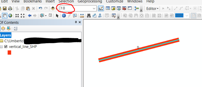
Surprisingly, at a scale of 1:0 ![]() I can see the label
I can see the label ![]()

- Mark as New
- Bookmark
- Subscribe
- Mute
- Subscribe to RSS Feed
- Permalink
I have had problems with vertical 3D geometries in ArcMap as described here: https://community.esri.com/people/xander_bakker/blog/2016/07/10/create-a-3d-tree-based-on-3d-polygon... . I know that ArcGIS Pro has a much better handling of 3D information. In case ArcGIS Pro is not giving you an acceptable result, you might try to create an idea to enhance the visualization.
- Mark as New
- Bookmark
- Subscribe
- Mute
- Subscribe to RSS Feed
- Permalink
Unfortunately, I ended up applying a small (1m) shift to the firstPoint coordinate of my vertical lines to be able to see the labels. Thanks for the feedback though! ![]()
- Mark as New
- Bookmark
- Subscribe
- Mute
- Subscribe to RSS Feed
- Permalink
It shouldn't need to be that large, as I suggested earlier. Only enough that the points are recognized as being different in the tolerance
- Mark as New
- Bookmark
- Subscribe
- Mute
- Subscribe to RSS Feed
- Permalink
Dan Patterson I know it, but 1 meter is totally fine for me. Thanks for reminding this anyway.