- Home
- :
- All Communities
- :
- Products
- :
- ArcGIS Pro
- :
- ArcGIS Pro Questions
- :
- Re: Calculate geometry (coordinates) errors Pro 2....
- Subscribe to RSS Feed
- Mark Topic as New
- Mark Topic as Read
- Float this Topic for Current User
- Bookmark
- Subscribe
- Mute
- Printer Friendly Page
Calculate geometry (coordinates) errors Pro 2.7
- Mark as New
- Bookmark
- Subscribe
- Mute
- Subscribe to RSS Feed
- Permalink
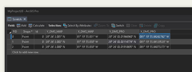
I've recently started using Pro for some processes I've done hundreds of times. After investigating some unexplained changes in the hundredth decimal place of some DMS coordinates I decided to compare Map vs. Pro calculate geometry results for some coordinates. Same shapefile, same geographic coordinate system NAD 83 (1986, the original one), no projection. The difference bewteen Map and Pro for the first coordinate pair longitude is 55.831" versus 55.843", similar results for the other coordinates as below with MAP being the ArcMap results and Pro being the Pro results.
Am I missing something or is this a bug with Pro's calculate geometry?
- Mark as New
- Bookmark
- Subscribe
- Mute
- Subscribe to RSS Feed
- Permalink
From the description in
Calculate Geometry Attributes (Data Management)—ArcGIS Pro | Documentation
Did you actually select/specify the output coordinate system? It says that the input coordinate system will be used by default, but then there is this confusing bit which says if not specified, WGS84 datum will be used. You might be wise to give a check and make sure that the input coordinate system appeared in the dialog name and wasn't blank
... sort of retired...
- Mark as New
- Bookmark
- Subscribe
- Mute
- Subscribe to RSS Feed
- Permalink
Weirdly Pro didn't give me the option to pick a coordinate system; (Map does, it picked up vanilla NAD 83 from this experiment's shapefile) once I changed the coordinate formant from same as input to DMS, the choose coordinate system options on Pro goes away, as below:
I did both the calculate geometries in a new blank map in an effort to make sure there was only coordinate system to work with. I have Pro options set to use the spatial reference of the first operational layer so it should just pick up the NAD 83 that this shapefile has:
- Mark as New
- Bookmark
- Subscribe
- Mute
- Subscribe to RSS Feed
- Permalink
I wonder if the difference may be the way ArcMap (32 bit) versus ArcGIS Pro (64 bit) handles floating point numbers internally. You are only seeing the difference at the 1/100 degree, right?
- Mark as New
- Bookmark
- Subscribe
- Mute
- Subscribe to RSS Feed
- Permalink
Correct. 0.01 seconds corresponds to about 1' on the ground where I am. Depending on what sort of task I'm working on 1' may or may not be an issue.
- Mark as New
- Bookmark
- Subscribe
- Mute
- Subscribe to RSS Feed
- Permalink
I guess you have to ask yourself, between the two applications, which one is 'correct'? Remember, ArcGIS , be it 'Classic' or 'Pro' is nothing more than a model of reality. 'A map is just a set of errors we all agree upon'...
If you need 1" precision in your location measurements, you may want to survey the sites.
- Mark as New
- Bookmark
- Subscribe
- Mute
- Subscribe to RSS Feed
- Permalink
Got me on that one, heh. But the reason it bothers me is this has resulted in submittals that contain the same set of points on different sheets where the same point has a different number in the hundredths place of the seconds. Sure most reviewers out there would likely ignore it as irrelevant and/or rounding error, but sometimes you run into a different breed of reviewer.
- Mark as New
- Bookmark
- Subscribe
- Mute
- Subscribe to RSS Feed
- Permalink
Understood.


