- Home
- :
- All Communities
- :
- Products
- :
- ArcGIS Pro
- :
- ArcGIS Pro Questions
- :
- Re: CADMAPPER to ARCPRO
- Subscribe to RSS Feed
- Mark Topic as New
- Mark Topic as Read
- Float this Topic for Current User
- Bookmark
- Subscribe
- Mute
- Printer Friendly Page
CADMAPPER to ARCPRO
- Mark as New
- Bookmark
- Subscribe
- Mute
- Subscribe to RSS Feed
- Permalink
Hello, I am currently working on a project that involves 3D buildings. I am using CAD data from CADMAPPER. When I transfer the CAD data into ArcPro the data shows up in the ocean. I tried to georeferenced the data in order to match he map, but to no avail. The file is a dxf by the way and I couldn't uploaded here because it won't let me.
- Mark as New
- Bookmark
- Subscribe
- Mute
- Subscribe to RSS Feed
- Permalink
By chance does the data show up off the west coast of Africa? If so, this is 0,0 space meaning the intersection of the Prime Meridian and the Equator. In the CAD data, is there an option to export a world file *.wld with the data?
- Mark as New
- Bookmark
- Subscribe
- Mute
- Subscribe to RSS Feed
- Permalink
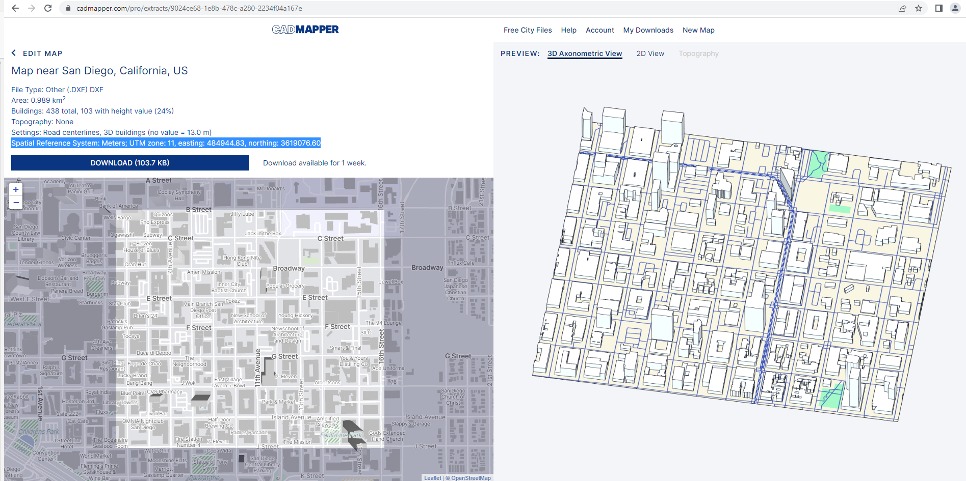
Yes, every time I upload the data directly into arcpro it shows up by West Coast Africa like you said. I tried using the spatial reference CADMAPPER gives me, Spatial Reference System: Meters; UTM zone: 11, easting: 484944.83, northing: 3619076.60, but still won't work.
"In the CAD data, is there an option to export a world file *.wld with the data?"
No, I don't get this option.
- Mark as New
- Bookmark
- Subscribe
- Mute
- Subscribe to RSS Feed
- Permalink
Okay - so I downloaded the *.dxf for Boulder/Denver and confirmed that it places the files at 0,0 space. In fact, the CADMAPPER FAQ confirms that the model files are at the origin (0, 0,0) so they are drawing as designed by CADMAPPER. But the key is getting the file georeferenced to a projected coordinate system in ArcGIS Pro. So you'll have to georeference the *.dxf so that it fits into projected space.
- Mark as New
- Bookmark
- Subscribe
- Mute
- Subscribe to RSS Feed
- Permalink
So in order for me to do this would it be to first use CAD to Geodatabase? Then set the parameters using the information from CADMAPPER?
By the way thank you so much for helping me with this.
- Mark as New
- Bookmark
- Subscribe
- Mute
- Subscribe to RSS Feed
- Permalink
You're welcome - happy to assist! I like figuring out conundrums like this.
So you mentioned parameters from CADMAPPER. What are they and do you have a screen grab of them?
- Mark as New
- Bookmark
- Subscribe
- Mute
- Subscribe to RSS Feed
- Permalink
So here is where I am at. I tried to make the basemap base on the CADMAPPER sugestions, I made the basemap have a spatial reference of WGS 1984 UMT Zone 11N. I then use CAD to Geodatabase and I filled out the parameters using the suggested data from CADMAPPER, Spatial Reference System: Meters; UTM zone: 11, easting: 484944.83, northing: 3619076.60. After doing all of this I still get my data in the ocean only this time is in the UTM Zone 11. LOL