- Home
- :
- All Communities
- :
- Products
- :
- ArcGIS Pro
- :
- ArcGIS Pro Questions
- :
- Best way to account for overlap when calculating t...
- Subscribe to RSS Feed
- Mark Topic as New
- Mark Topic as Read
- Float this Topic for Current User
- Bookmark
- Subscribe
- Mute
- Printer Friendly Page
Best way to account for overlap when calculating total distance of routes travelled
- Mark as New
- Bookmark
- Subscribe
- Mute
- Subscribe to RSS Feed
- Permalink
I'm Looking for ideas of how to calculate total route distance. There are thousand of trips and some go through the same road and i want to exclude the overlaps. so that each distance covered is not calculated multiple times when there are more than one trip that takes that road. I want the distance to be calculated once. I have the data lines showing the route on top of each other at the moment. at the end i need a total distance in meters. Thanks for your input.
Solved! Go to Solution.
Accepted Solutions
- Mark as New
- Bookmark
- Subscribe
- Mute
- Subscribe to RSS Feed
- Permalink
If that section of road is never to be counted again in any trip, then I would assume you just merge all the routes into a single feature (if this is not already the case), dissolve Dissolve (Data Management)—ArcGIS Pro | Documentation to remove overlapping segments, then sum the lengths of the remaining polylines.
- Mark as New
- Bookmark
- Subscribe
- Mute
- Subscribe to RSS Feed
- Permalink
Shape_Length seems a strange value, what coordinate system is the data in? Probably use Calculate Geometry Attributes (Data Management)—ArcGIS Pro | Documentation and specify the correct coordinate system and length units. You could probably use LENGTH_GEODESIC however I would personally prefer to ensure the original feature is in the correct coordinate system initially.
- Mark as New
- Bookmark
- Subscribe
- Mute
- Subscribe to RSS Feed
- Permalink
If that section of road is never to be counted again in any trip, then I would assume you just merge all the routes into a single feature (if this is not already the case), dissolve Dissolve (Data Management)—ArcGIS Pro | Documentation to remove overlapping segments, then sum the lengths of the remaining polylines.
- Mark as New
- Bookmark
- Subscribe
- Mute
- Subscribe to RSS Feed
- Permalink
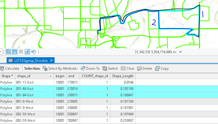
Thank You David for your reply! From your explanation it seems straightforward but just wanted to confirm I'm on the right path. I attached a screenshot of how the data is in the attribute. all the routes is in one feature. I ran the dissolve tool but they lines were not split at the junctions where they meet. They are still on top of each other. Can you help me?
- Mark as New
- Bookmark
- Subscribe
- Mute
- Subscribe to RSS Feed
- Permalink
No problem, the picture certainly helps. What arguments (options) did you specify in the tool? The defaults should combine the lines into a single feature if they intersect (touch). I'd ensure you've not specified any 'Dissolve Fields' or checked 'Unsplit Lines' options - simply 'Input feature class' and 'output feature class' then run the tool.
- Mark as New
- Bookmark
- Subscribe
- Mute
- Subscribe to RSS Feed
- Permalink
Shape_Length seems a strange value, what coordinate system is the data in? Probably use Calculate Geometry Attributes (Data Management)—ArcGIS Pro | Documentation and specify the correct coordinate system and length units. You could probably use LENGTH_GEODESIC however I would personally prefer to ensure the original feature is in the correct coordinate system initially.