- Home
- :
- All Communities
- :
- Products
- :
- ArcGIS Pro
- :
- ArcGIS Pro Questions
- :
- Re: Attribute Rules: Update Attributes
- Subscribe to RSS Feed
- Mark Topic as New
- Mark Topic as Read
- Float this Topic for Current User
- Bookmark
- Subscribe
- Mute
- Printer Friendly Page
Attribute Rules: Update Attributes
- Mark as New
- Bookmark
- Subscribe
- Mute
- Subscribe to RSS Feed
- Permalink
I have old features that I am adding via copy and paste to a current production feature class that has attribute rules enabled. I am having trouble figuring out a way to update "at will" specific fields that are null for the old features being brought in.
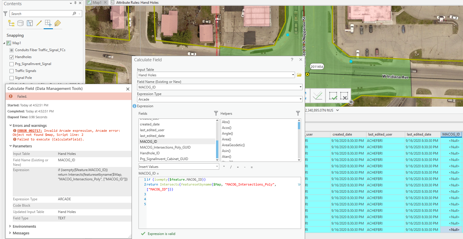
The attribute rule for the current feature populates point data fields with data from a polygon boundary vi INTERSECT, but when I perform the copy and past the fields remain null and are not updated via the attribute rule.
I know with attribute assistant you can "Run Change Rules for Selected Features" is there a simple way to do this with attribute rules or mimics the rule using ARCADE or Python in the field calculator as I attempted below?

- Mark as New
- Bookmark
- Subscribe
- Mute
- Subscribe to RSS Feed
- Permalink
Hi Brian Acheff ,
The error message is indicating that you cannot use the $map global variable in a field calculation of an attribute calculation rule. You should use the $datastore instead. See Profiles | ArcGIS for Developers for more information on what global variables and functions are available in each profile.
- Mark as New
- Bookmark
- Subscribe
- Mute
- Subscribe to RSS Feed
- Permalink
Thank you for noticing my simple mistake.
When I use $datastore the expression check out, but returns nothing.

I noticed the $editcontext.editType global for attribute rules and the following expression:
if ($editContext.editType == "UPDATE")
would this need to be inserted into the expression or would I need to create a rules using this and then when field calculating call out the if ($editContext.editType == "UPDATE") ?
- Mark as New
- Bookmark
- Subscribe
- Mute
- Subscribe to RSS Feed
- Permalink
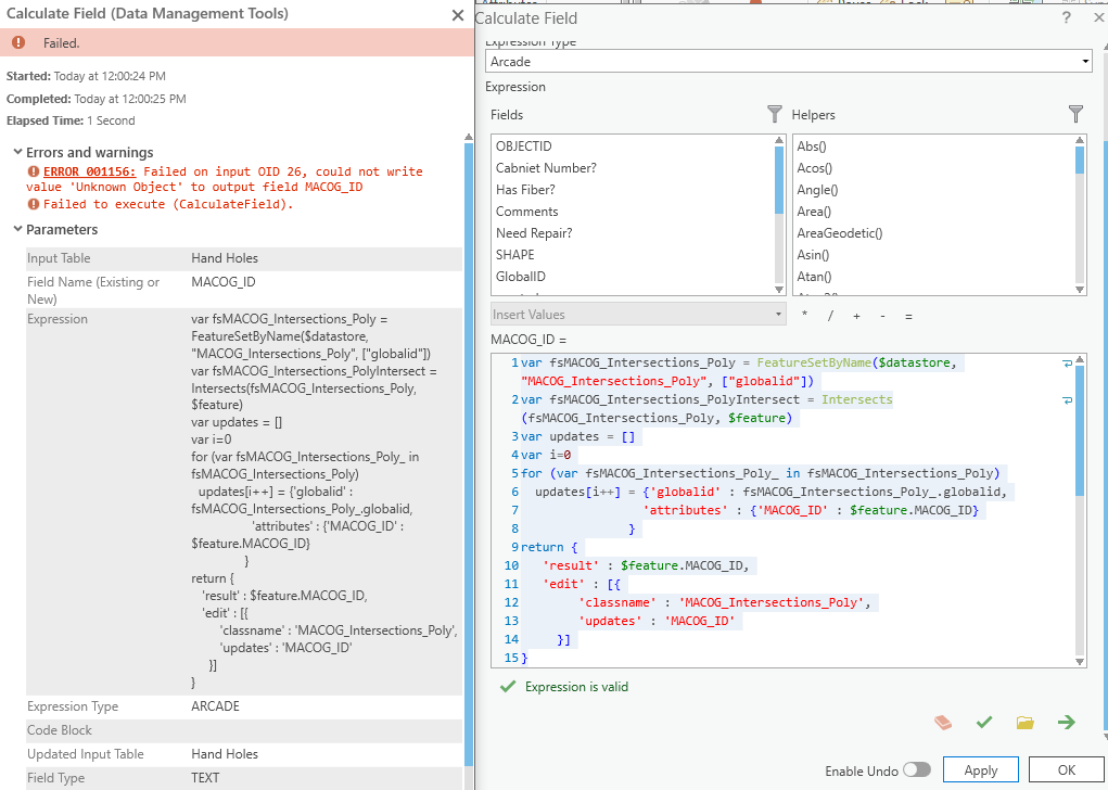
This checks out, but returns this error, would you be able to point me in the correct direction or if I am headed in the correct direction with this script?

- Mark as New
- Bookmark
- Subscribe
- Mute
- Subscribe to RSS Feed
- Permalink
Hi Brian Acheff ,
In this screenshot on line 13 you are using as update the text 'MACOG_ID'. This should be updates array you created before. See algo the example expression called "Edit another feature class with a calculation rule." in this link: Attribute rule script expression examples—ArcGIS Pro | Documentation
- Mark as New
- Bookmark
- Subscribe
- Mute
- Subscribe to RSS Feed
- Permalink
Xander Bakker helped me out here: https://community.esri.com/thread/259345-attribute-rule-for-intersecting-layer when I had a problem with updating points or lines with underlying feature layers.
- Mark as New
- Bookmark
- Subscribe
- Mute
- Subscribe to RSS Feed
- Permalink
Thank you for you help.
Joe's forward of his trouble with this showed me to Xander's remark to not use $feature."field name" and instead use $feature["field name"].
The expression was not done as an attribute rule, but rather as a geoprocessing field calculation, though I did disable then re-enable the attribute rule associated with Intersect, so I cannot be sure if the that helped at all.
This is the correct expression:


- Mark as New
- Bookmark
- Subscribe
- Mute
- Subscribe to RSS Feed
- Permalink
Hi Brian Acheff ,
Let me respond to this comment first. When you return the First record of an intersect, you are returning an entire record. Not only the MACOG_ID value even though it is the only attribute you are requesting. You would have to query the actual field to get the value (adding for instance ["MACOG_ID"] at the end of the line).
- Mark as New
- Bookmark
- Subscribe
- Mute
- Subscribe to RSS Feed
- Permalink
I am confused by your reply, used the expression to field calculate the MACOG_ID field in the HandHold feature class (the $feature) that intersects the MACOG_Intersections_Poly.
Could you elaborate on your reply?
- Mark as New
- Bookmark
- Subscribe
- Mute
- Subscribe to RSS Feed
- Permalink
Hi Brian.Acheff ,
Maybe it is best to show what I mean it the expression:
if ($feature["MACOG_ID"] == null) {
// first returns a feature
var feat = First(Intersects(FeatureSetByName($datastore, "MACOG_Intersections_Poly", ["MACOG_ID"]), $feature));
// access the attribute to return the actual value
return feat["MACOG_ID"];
}