- Home
- :
- All Communities
- :
- Products
- :
- ArcGIS Pro
- :
- ArcGIS Pro Questions
- :
- Re: Arcgis Pro - Summarize Within
- Subscribe to RSS Feed
- Mark Topic as New
- Mark Topic as Read
- Float this Topic for Current User
- Bookmark
- Subscribe
- Mute
- Printer Friendly Page
- Mark as New
- Bookmark
- Subscribe
- Mute
- Subscribe to RSS Feed
- Permalink
I am trying to find out the average value of a nearby polygons using the Summarize within tool.
The problem I am running into is that the average is not what I expect it to be if I average it manually.
From the tool reference page Summarize Within—Help | Documentation
in_polygons | The polygons used to summarize the features, or portions of features, in the input summary layer. |
I think that it is using Portions of features within the 40 ft buffer I am using. I cannot find any documentation on when it uses a portion or all. I have tried getting the average of a polygon that has all of 4 buildings in it and it does not even get the average right when I would think that all the polygon would be used. At this point I don't know how it calculates "mean".
The page defines: Mean—Calculates the average of all the points in each polygon.
Any suggestions?
Solved! Go to Solution.
Accepted Solutions
- Mark as New
- Bookmark
- Subscribe
- Mute
- Subscribe to RSS Feed
- Permalink
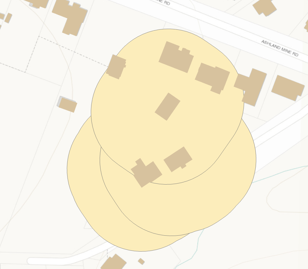
Dan Patterson I just reviewed that tech support bug and the case logged is non repro in current Pro versions. The weighted mean computation appears correct. Here is the math I used for the black border polygon summarizing the two colored polygons inside it. The mean Score calculated for the output is based on the ratio of overlap between the two summary features. The yellow feature accounts for 95% of the total overlap, so the weighted score will be much closer to that value. The orange polygon has a higher value, but only accounts for ~5% of the overlap, so it just nudges the mean value up a little.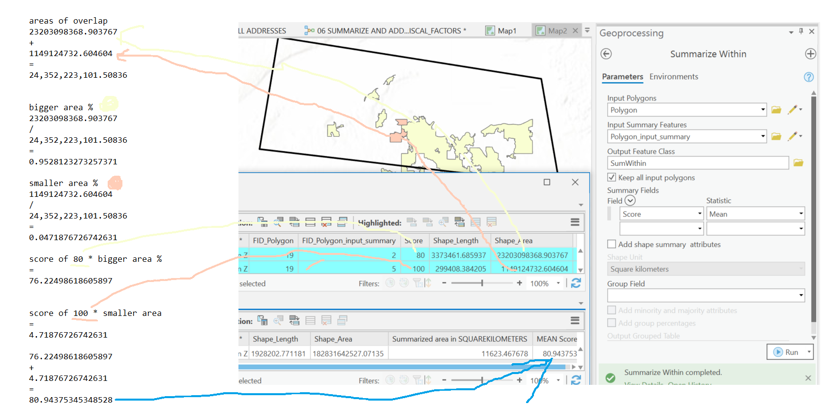
- Mark as New
- Bookmark
- Subscribe
- Mute
- Subscribe to RSS Feed
- Permalink
draw the polygon with no fill. I am wondering if the top polygon clips the building closest to its perimeter in the north end, which would leave you with one polygon that contains 2 buildings.
- Mark as New
- Bookmark
- Subscribe
- Mute
- Subscribe to RSS Feed
- Permalink
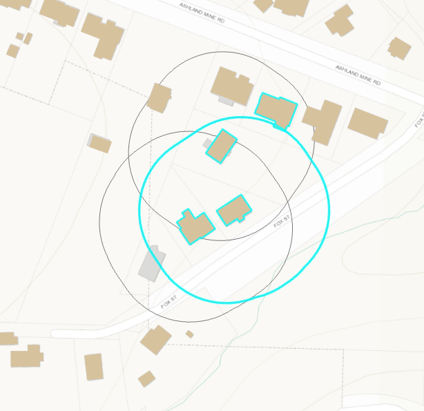
Here are the 4 values of the buildings that touch the polygon.
| 35.33333 |
| 46.5 |
| 44.83333 |
| 38.66667 |
Here is the mean that the output results.
| 43.646452 |
- Mark as New
- Bookmark
- Subscribe
- Mute
- Subscribe to RSS Feed
- Permalink
Dan Patterson Well I guess I will look for a different way to do this...
Thanks for finding the tech support bug.
- Mark as New
- Bookmark
- Subscribe
- Mute
- Subscribe to RSS Feed
- Permalink
I shall marked as assumed answered then
- Mark as New
- Bookmark
- Subscribe
- Mute
- Subscribe to RSS Feed
- Permalink
Dan Patterson I just reviewed that tech support bug and the case logged is non repro in current Pro versions. The weighted mean computation appears correct. Here is the math I used for the black border polygon summarizing the two colored polygons inside it. The mean Score calculated for the output is based on the ratio of overlap between the two summary features. The yellow feature accounts for 95% of the total overlap, so the weighted score will be much closer to that value. The orange polygon has a higher value, but only accounts for ~5% of the overlap, so it just nudges the mean value up a little.
- Mark as New
- Bookmark
- Subscribe
- Mute
- Subscribe to RSS Feed
- Permalink
Ok that makes sense now, if they do indeed intersect the portion of the building that intersects with the circle. The simple addition average you show would only be for buildings *completely within* the circle.
- Mark as New
- Bookmark
- Subscribe
- Mute
- Subscribe to RSS Feed
- Permalink
Hi Rickey Fite,
The mean is an area-weighted mean of those four buildings. The building that has the most overlap will contribute more towards the mean.
Based on your pictured values and the output mean value it is very hard to tell if the value is correct, there just isnt enough information. We need to know the area of overlap between the highlighted circle and each building that intersects it, then we weight those buildings values by how much of the total overlap they contribute. If you want me to double check the match and send you the results, send a sample dataset to [email protected].
The mean WILL NOT be the average of (35.33333+46.5+44.83333+38.66667)/4. Doing an average like this throws away the spatial component of the analysis, since each of those buildings spatially overlaps the highlighted circle different.
If you want a simplified result that does the basic average I just described, Spatial Join can accomplish it using a MEAN Merge Rule. Spatial Join—Help | Documentation
- Mark as New
- Bookmark
- Subscribe
- Mute
- Subscribe to RSS Feed
- Permalink
Thank you for getting back to me on this! it is very helpful. i might have uses for this in the future. I have now been told that this is not the calculation we want run. I will be posting a new question and will link it here when its up.
https://community.esri.com/message/917615-arcgis-pro-model-builder-help