- Home
- :
- All Communities
- :
- Products
- :
- ArcGIS Pro
- :
- ArcGIS Pro Questions
- :
- ArcGIS Pro and ArcMap Alignment Issues
- Subscribe to RSS Feed
- Mark Topic as New
- Mark Topic as Read
- Float this Topic for Current User
- Bookmark
- Subscribe
- Mute
- Printer Friendly Page
ArcGIS Pro and ArcMap Alignment Issues
- Mark as New
- Bookmark
- Subscribe
- Mute
- Subscribe to RSS Feed
- Permalink
Dear communities,
The software that I am using is ArcGIS Pro 2.7.1 and ArcMap 10.7.1.
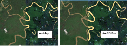
Landsat imagery was first downloaded from an open-source with a coordinate system 'GCS_WGS_1984', and I want to project the imagery with coordinate system 'Timbalai_1948_RSO_Borneo_Meters'. Therefore, the Resample tool was used in ArcMap with a specification of the output coordinate system (Timbalai_1948_RSO_Borneo_Meters) in the processing environment. The product/output does align with the basemap of ArcMap, but it doesn't align in ArcGIS Pro:
However, the original Landsat imagery that I first downloaded does align with the basemap in both ArcMap and ArcGIS Pro. Most online resources stated possible geographic transformation issues. However, I do check and ensure that the coordinate system of the data frame/Layers(ArcMap)/Map(ArcGIS Pro) is the same as the projected Landsat which is 'Timbalai_1948_RSO_Borneo_Meters'
Also, the same issue occurs when I convert a vector land cover map (coordinate system 'GCS_WGS_1984') to a raster in ArcGIS Pro with specifying the output coordinate system as 'Timbalai_1948_RSO_Borneo_Meters' (I was hoping the projecting process can be done together with the conversion process. Is this a proper way of doing?). The raster map does align well with the vector map in ArcGIS Pro, but it doesn't align with the vector map when inserted into ArcMap.
So my observation is that the product generated in ArcGIS Pro doesn't align when inserted into ArcMap, and vice versa. Is there a bug? or There are problems throughout the process?
Sorry for my lengthy words. Any advice or guidance is much appreciated.
From: a humble new GIS user
Solved! Go to Solution.
Accepted Solutions
- Mark as New
- Bookmark
- Subscribe
- Mute
- Subscribe to RSS Feed
- Permalink
Am I understanding correctly that you're using the Resample tool and setting a geoprocessing environment to change the projection? Are you also specifying the correct Transformation as an environment?
Any offset not caused by a poor specified transformation could also be due to slightly different resampling techniques between the platforms, but that's just a guess.
However, I would highly recommend using the Project Raster (Data Management)—ArcGIS Pro | Documentation tool and utilising the best transformation for your area.
- Mark as New
- Bookmark
- Subscribe
- Mute
- Subscribe to RSS Feed
- Permalink
This turns out to be a known bug in ArcMap. It seems that adding Basemp will change the coordinate system of the data frame. The suggested workaround by Esri support:
- Go to the View menu > Data Frame Properties > Coordinate System and change the coordinate system back to the correct spatial reference.
- If working with the same basemap layer frequently, the basemap layer can be saved as a layer file. In the Table of Contents, in either the Drawing Order view or the Visibility view, right-click the basemap layer > Save As Layer File. The next time this basemap layer is needed, browse to the saved layer file (.lyr) and add it to the map. This method of adding the basemap does not change the data frame coordinate system.
Hope this helps.
- Mark as New
- Bookmark
- Subscribe
- Mute
- Subscribe to RSS Feed
- Permalink
Am I understanding correctly that you're using the Resample tool and setting a geoprocessing environment to change the projection? Are you also specifying the correct Transformation as an environment?
Any offset not caused by a poor specified transformation could also be due to slightly different resampling techniques between the platforms, but that's just a guess.
However, I would highly recommend using the Project Raster (Data Management)—ArcGIS Pro | Documentation tool and utilising the best transformation for your area.
- Mark as New
- Bookmark
- Subscribe
- Mute
- Subscribe to RSS Feed
- Permalink
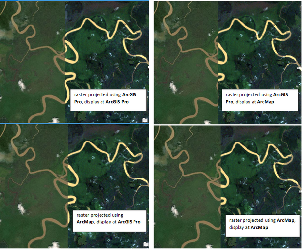
Yeah, I am using the Resample tool and setting the geoprocessing environment to change the projection to 'Timbalai_1948_RSO_Borneo_Meters'. I did try using the Project Raster tool in ArcMap, but the projected Landsat raster didn't align with the basemap of ArcMap, therefore I changed to use Resample tool which works (the left image on the post above). However, I just find out that the projected raster can align with the basemap of ArcGIS Pro.
I make another attempt to use the Project Raster tool in both ArcGIS Pro and ArcMap. I find out that the two projected raster can align well with the basemap of ArcGIS Pro but not with the basemap of ArcMap (even though one is projected using ArcMap) :
- Mark as New
- Bookmark
- Subscribe
- Mute
- Subscribe to RSS Feed
- Permalink
This turns out to be a known bug in ArcMap. It seems that adding Basemp will change the coordinate system of the data frame. The suggested workaround by Esri support:
- Go to the View menu > Data Frame Properties > Coordinate System and change the coordinate system back to the correct spatial reference.
- If working with the same basemap layer frequently, the basemap layer can be saved as a layer file. In the Table of Contents, in either the Drawing Order view or the Visibility view, right-click the basemap layer > Save As Layer File. The next time this basemap layer is needed, browse to the saved layer file (.lyr) and add it to the map. This method of adding the basemap does not change the data frame coordinate system.
Hope this helps.

