- Home
- :
- All Communities
- :
- Products
- :
- ArcGIS Pro
- :
- ArcGIS Pro Questions
- :
- Re: ArcGIS Pro 2.9.1 Raster NoData Showing as Whit...
- Subscribe to RSS Feed
- Mark Topic as New
- Mark Topic as Read
- Float this Topic for Current User
- Bookmark
- Subscribe
- Mute
- Printer Friendly Page
ArcGIS Pro 2.9.1 Raster NoData Showing as White
- Mark as New
- Bookmark
- Subscribe
- Mute
- Subscribe to RSS Feed
- Permalink
ArcGIS Pro 2.9.1
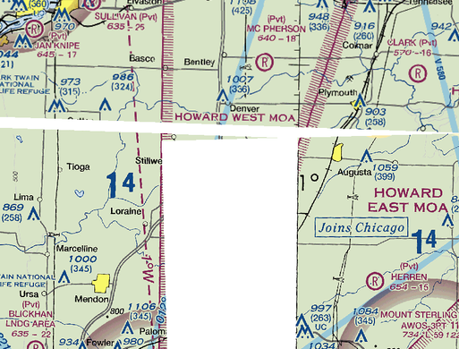
I downloaded a couple of FAA Sectionals as GeoTiffs from here and clipped them using the "Clip Raster" tool. I assigned the "NoData Value" field to 256. In the new GeoTiff the NoData area is displaying as white and not clear. In the Layer Properties under Raster Information, the NoData Value field has a value of 256. The symbology for both the original GeoTiff and the clipped GeoTiff is set to "Colormap". In ArcMap 10.2.1 the NoData shows up as clear.
I'm a little stumped at why the NoData is showing white. Anyone know of another setting somewhere?
- Mark as New
- Bookmark
- Subscribe
- Mute
- Subscribe to RSS Feed
- Permalink
Check the symbology of the layer, in particular the mask. NoData should be set to “No color” (see the attached).
— Andy
- Mark as New
- Bookmark
- Subscribe
- Mute
- Subscribe to RSS Feed
- Permalink
That is what I have it set as:
- Mark as New
- Bookmark
- Subscribe
- Mute
- Subscribe to RSS Feed
- Permalink
That should do it.
The only other thing I can think of is that a colormap typically uses up much less than 256 values, and perhaps you can get away with assigning NoData to 255 (or some other unused value). If nothing else that should halve the size of your raster since it won’t then need to use 16-bit unsigned integers for the colormap. Guessing that ArcGIS Pro isn’t handling them properly since it’s an unusual situation.
— Andy
- Mark as New
- Bookmark
- Subscribe
- Mute
- Subscribe to RSS Feed
- Permalink
Unfortunately Pro is still showing No Data as white. I'm really stumped on this one.
Will
- Mark as New
- Bookmark
- Subscribe
- Mute
- Subscribe to RSS Feed
- Permalink
ArcMap has such issue. To understand if you really have nodata value better open it in qgis. It might represent quite different. You can try also mark/unmark alpha channel in symbology - RGB composite


