- Home
- :
- All Communities
- :
- Products
- :
- ArcGIS Pro
- :
- ArcGIS Pro Questions
- :
- Arcade Calculate Field -- Error Help Please
- Subscribe to RSS Feed
- Mark Topic as New
- Mark Topic as Read
- Float this Topic for Current User
- Bookmark
- Subscribe
- Mute
- Printer Friendly Page
Arcade Calculate Field -- Error Help Please
- Mark as New
- Bookmark
- Subscribe
- Mute
- Subscribe to RSS Feed
- Permalink
Hello,
I'm using ArcGIS Pro to calculate total percent of parcels in a hazard zone. For this I used the tabulate intersection tool, and successfully was able to get a pivot table that shows each parcel in a city limit that overlaps with a certain hazard. Right now, I am working with flood data, so my pivot table's has A, AE, VE, and X flood zone fields. Since there are over 3,000 parcels, I don't want to calculate what parcel is in what flood zone manually, so I created a new field "High_Zone". I was going to use the stats with city and flood zone as my axes, but the graph repeats parcels because I did not specify any overlap classification.
The classification I need to use is: if a parcel is 45% or more in a zone, then I will say that whole parcel is in that zone. But, I want to make sure that the parcels that are 45% or more in zone X to be prioritized before any other zone since it is more dangerous. So, I tried doing this code block in my High_Zone field, but am running into errors. I am using Arcade (but I did try using python but also ran into issues -- got the error on line 1, identifier expected, but I before I redid my code I kept getting open parenthesis expected).
For more clarity:
My pivot table looks like this:
I want High_Zone field to output a flood zone with more than 45% (I do use 44.5% in my code because I think that range is still very close enough to classify as primary hazard in that parcel)
| Parcel ID | City | A | AE | VE | X | High_Zone |
| 123456 | XXXX | null | 51.2 | null | 44.5 | X (although AE if higher %. because I am going for ~45% I want to include 44.5% of X, the more dangerous hazard) |
| 78910 | AAAA | 73 | 10 | null | null | A |
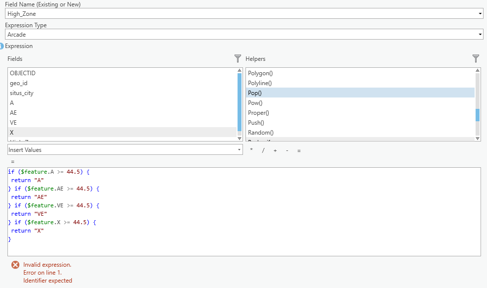
if ($feature.A >= 44.5) {
 return "A"
} if ($feature.AE >= 44.5) {
 return "AE"
} if ($feature.VE >= 44.5) {
 return "VE"
} if ($feature.X >= 44.5) {
 return "X"
}
if ($feature.A >= 44.5) {
 return "A";
}
if ($feature.AE >= 44.5) {
 return "AE";
}
if ($feature.VE >= 44.5) {
 return "VE";
}
if ($feature.X >= 44.5) {
 return "X"
}
Edit: I just tried the second code and I got no errors, but aside from one AE, and all A, all outputs are null
- Mark as New
- Bookmark
- Subscribe
- Mute
- Subscribe to RSS Feed
- Permalink
With multiple conditions, you should include else in your code to indicate the order in which things are to evaluate. As you state, you want zone X to be prioritized, so you list it first in the series of conditions.
By using "else if" for the following condition, it will evaluate only if the preceding condition is False, that is, X is not greater than the threshold.
var f = $feature
var t = 44.5

if (f.X >= t) {
    return 'X'
} else if (f.A >= t) {
    return 'A'
} else if (f.AE >= t) {
    return 'AE'
} else if (f.VE >= t) {
    return 'VE'
} else {
    return 'No High Zone'
}
Also, by including a final 'else', we give the code an output for when all conditions evaluate as False.
Could you clarify, though: if two zones are above 44.5%, would you want them both in the output field? That would require a different bit of code than this.
Kendall County GIS
- Mark as New
- Bookmark
- Subscribe
- Mute
- Subscribe to RSS Feed
- Permalink
Hi,
Thank you for helping me! To answer your question, I would want only one output, prioritized from highest to lowest in risk, but with flood zones in general not sure which is worse. For other hazards I am working on, I am just scaling downwards in class. For example, with seismic I would go from highest shaking intensity to lowest, top-down, in code. To clarify here's what I wrote in my code block for flood:
if ($feature.X >= 44.5) {
 return "X"
}
if ($feature.A >= 44.5) {
 return "A";
}
if ($feature.AE >= 44.5) {
 return "AE";
}
if ($feature.VE >= 44.5) {
 return "VE";
}
From what I saw, the output looked correct, are there potential problems with my code? I planned on using this general format for all other hazards as well.