- Home
- :
- All Communities
- :
- Products
- :
- ArcGIS Pro
- :
- ArcGIS Pro Questions
- :
- 10.6 Buffer Wizard crashing
- Subscribe to RSS Feed
- Mark Topic as New
- Mark Topic as Read
- Float this Topic for Current User
- Bookmark
- Subscribe
- Mute
- Printer Friendly Page
10.6 Buffer Wizard crashing
- Mark as New
- Bookmark
- Subscribe
- Mute
- Subscribe to RSS Feed
- Permalink
I installed 10.6 yesterday late and noticed today that the buffer wizard crashes ArcMap every time I try to use it. I used the buffer tool instead but figured I would make a note of this indirectly for tech support. Here is an error message from Event Viewer:
Faulting application name: ArcMap.exe, version: 10.6.0.8321, time stamp: 0x5a2b5885
Faulting module name: ucrtbase.dll, version: 10.0.16299.125, time stamp: 0x9e3394c7
Exception code: 0xc0000409
Fault offset: 0x00091912
Faulting process id: 0x2234
Faulting application start time: 0x01d39154445590b7
Faulting application path: C:\Program Files (x86)\ArcGIS\Desktop10.6\bin\ArcMap.exe
Faulting module path: C:\WINDOWS\System32\ucrtbase.dll
Report Id: 879c0a8d-cd27-4f28-8c37-c971a354e504
Faulting package full name:
Faulting package-relative application ID:
- Mark as New
- Bookmark
- Subscribe
- Mute
- Subscribe to RSS Feed
- Permalink
Thanks xander_bakker and johns I am off to a training this morning but will try to grab some time to look at this this afternoon. I'll follow up then. Cheers.
- Mark as New
- Bookmark
- Subscribe
- Mute
- Subscribe to RSS Feed
- Permalink
johns Are you able to use the Buffer (Analysis) geoprocessing tool? I'm just curious whether there is something about the buffer wizard that you use that the gp tool doesn't provide...
- Mark as New
- Bookmark
- Subscribe
- Mute
- Subscribe to RSS Feed
- Permalink
I ended up using the Buffer Analysis tool. I use the buffer wizard mostly because I've been using it for years, it is simple and convenient, I sometimes only need a graphic and it never produces true curves even if the output is a feature class. (I hate true curves.) But this is not a major issue problem for me now that I know it is a bug.
- Mark as New
- Bookmark
- Subscribe
- Mute
- Subscribe to RSS Feed
- Permalink
Good to know. Thanks, John.
- Mark as New
- Bookmark
- Subscribe
- Mute
- Subscribe to RSS Feed
- Permalink
Interesting "valid horizon of this coordinate system" implies the wizard has been extended to support 3D data. It is probably not handling Z=No Data correctly. Secondly, ESRI must have also added some new 'error checking' at 10.6 that was not their before (I've never had a buffer 'clipped' based on a selected coordinate system).
For example, UTM zones are not necessarily mathematically limited (i.e, east-west UTM Zone 19 coordinates can be used to reference a position that would fall within UTM Zone 18 or 20, that is because we use false eastings in the UTM definition).
- Mark as New
- Bookmark
- Subscribe
- Mute
- Subscribe to RSS Feed
- Permalink
I'm having the same issue. Doing exactly the same as I did in 10.5, but it's now crashing. I use this tool a lot for creating multiple ring buffers around polygons (in order to create a faded edge on a map). I'm now using the multiple ring buffer script instead (found in ArcToolbox), but it's really time consuming having to add the distance values manually. The buffer wizard allowed you to enter the total distance and the number of rings and it would then calculate each buffer distance automatically.
- Mark as New
- Bookmark
- Subscribe
- Mute
- Subscribe to RSS Feed
- Permalink
Not that this would be a 1:1 solve for creating multiple ring buffers with the buffer wizard, but for the use case of creating faded edges, you could look into using the gradient fill option in ArcGIS Pro.
Fill symbol layers—ArcGIS Pro | ArcGIS Desktop
- Mark as New
- Bookmark
- Subscribe
- Mute
- Subscribe to RSS Feed
- Permalink
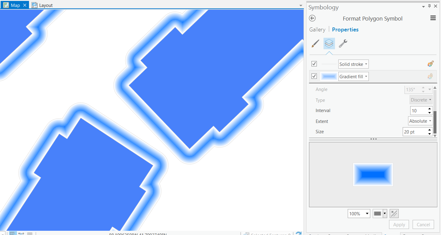
Thanks, that's a useful suggestion (you can also do gradient fills in ArcMap), which I hadn't thought of. However, I want to have the gradient colours go from transparent (close to the polygon) to white (further away from the polygon). This way, I get a nice faded edge showing the basemap underneath fade out to nothing. I tried changing the blue in the screenshot below to 'no colour' but it doesn't work (just shows as white). Any thoughts? With the multiple buffer rings, I used to add a field that contained transparency values, which I used to alter the transparency of each of the rings.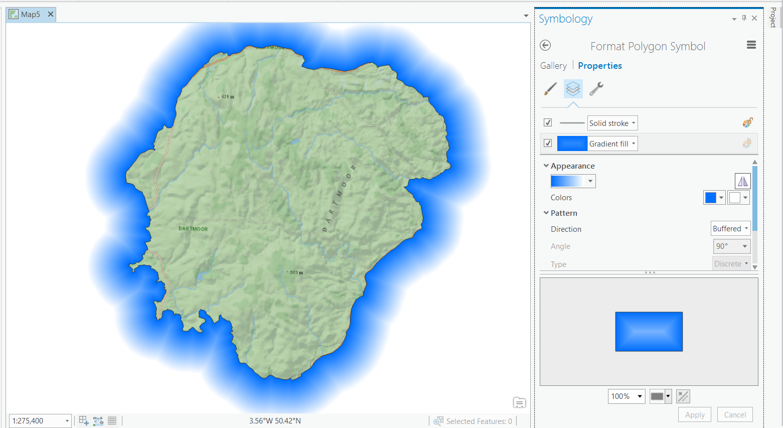
- Mark as New
- Bookmark
- Subscribe
- Mute
- Subscribe to RSS Feed
- Permalink
You could give that blue some transparency by clicking its dropdown arrow > Color Properties to open the Color Editor and setting transparency:
Maybe that will help.
- Mark as New
- Bookmark
- Subscribe
- Mute
- Subscribe to RSS Feed
- Permalink
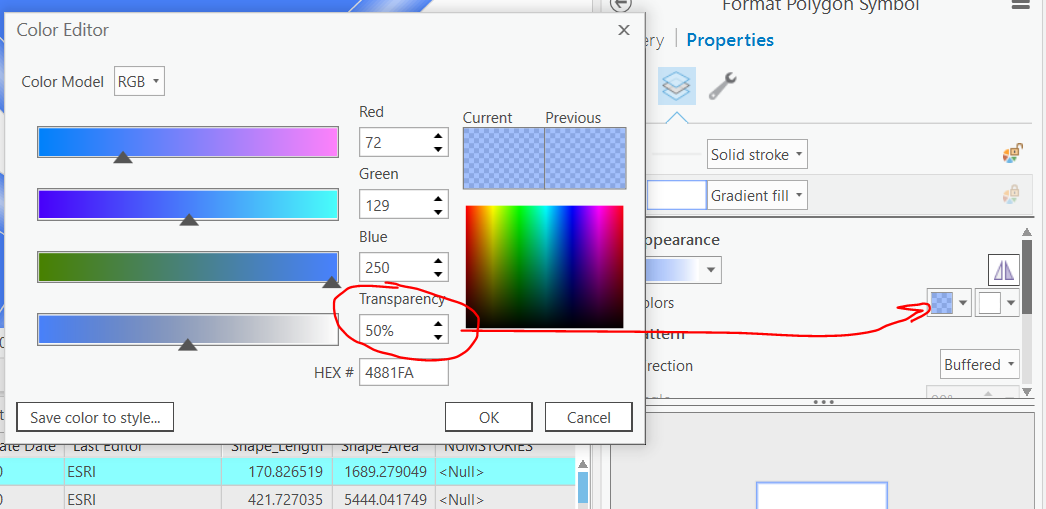
Ooh I didn't realise you could change transparency of individual colours in ArcGIS Pro (great feature!). However, it still doesn't seem to work for gradient fills - unless I'm missing something? The colour changes in the preview icon, but on the map it stays the same (i.e. as if it was 0% transparent). See below, first screenshot the blue has 0% transparency, second screenshot the blue has 100% transparency. I've tried with 50% or 90%, etc, but nothing changes it.
![]()
![]()