- Home
- :
- All Communities
- :
- Products
- :
- ArcGIS Pro
- :
- ArcGIS Pro Ideas
- :
- Point label position from field
- Subscribe to RSS Feed
- Mark as New
- Mark as Read
- Bookmark
- Follow this Idea
- Printer Friendly Page
Point label position from field
- Mark as New
- Bookmark
- Subscribe
- Mute
- Subscribe to RSS Feed
- Permalink
I would like the ability to use a field to set the anchor/zone position of the label. For example, the point would have an anchor value of 7 or S which would place the label in the center under the point.
This could also be achieved by allowing the user to set the offset from an field, e.g. x = 0 and y = -1 would place the label in the center, underneath the point.
I have been doing this since the day MapLex came out. 14 years or so.
I created a domain first. Short integer
0 Dynamic
1 North
2 North East.
etc.
Then have a Label Direction Field. I default it to Zero.
Then in your labels create 9 rules for labels. One for each of the 8 directions and one for Zero
However, I quit doing it as it became inefficient and switched to using Rotate By Attribute is it is a lot more flexible. Not sure what you want above what already exists. Can you be more specific.
. 
Ordnance Survey provide stylesheets for their MasterMap product in the form of QML, SLD and Layer files. The data contains values to determine the labels position around the point along with its rotation. The SLD and QML files work fine because GeoServer and QGIS allow every label setting to be driven by an attribute value. I think ESRI have fallen behind in this respect. The layer file rotates the label fine but it defaults to best position which means street names where "High" and "Street" are separate points look odd.
In your example, does Maplex take with integer or the text value (1 or North) to determine position or does it use both?
Does it have to a domain?
Where and how do you set the rule?
Thanks
You don't have to use a domain. I used a domian to help eliminate numbers that are not valid. it could be a text domain.
I used short integer because it takes up less space.
The value 1 in the domain shows as North in the drop down.
Conversely if you use a rotation of 360 for the label you can place it exactly at that rotation. You would create a field, for the sake of ease I call it Label_Rotation and make it a short integer.
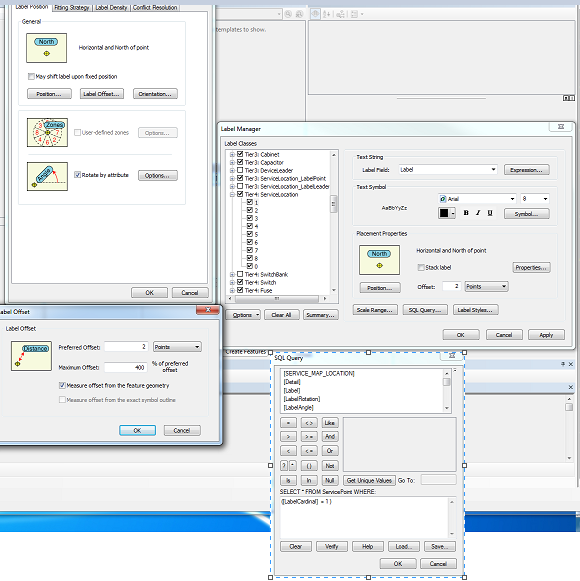
You set the rules for labeling up in Label Manager. As shown below. The SQL Query is set to only show those with a Cardinal Direction of 1. And it only displays them to the North. There is not set rule. You can call 1 anything.
Then I set the offset to 2 as shown, and the max offset to 400% as shown. this gives it some flexibility as to how far it will place the label and try to avoid overlap with other labels. 0 (zero) I have as dynamic. So if the cardinal direction has not been entered it will place the label dynamically.
Hi Robert Borchert,
Thanks for your response. I understand how you have done this however it won't work in my case. The feature class already has several label classes to style the text differently depending on whether it's road, place name, water etc. As far as I'm aware you can't have label sub-classes.
The option to define label style and placement properties through attribute data is something ESRI really need to consider. This would be as well as and independent from label classes. This functionality has been available in QGIS for several releases.
But you can. It takes minor clever setting up. How many different attributes are you talking about?
I did an experiment with labeling that I thought was pretty clever. In my test set I had some 200 points. I set it up so each label could have a different font, different size, different color, be rotated, be angled. the only thing I did not solve was changing the distance from the Point. I did this before Python was a thing. You do it using Text Formatting Tags, which have been a part of ArcGIS for quite a long time. I set it up with attributes for each Tag. I had a font attribute. In it I put the Font Name.
This is the expression to change a font to Arial. I substitute in the expression the Font Attribute. You can do the same for the size entry.
"<FNT name=""Arial"" size=""18"">" & [LABELFIELD] & "</FNT>"
You can do a search in the help for all the Formatting Tags available.
Ok, So i would set up 9 classes, one for each position, then set conditional formatting using the tags in the label expression. It's a little convoluted but it could work. I'll give it a go and let you know.
I created 9 label classes, one for each position, then use a label expression to define the colour, font and size. The problem now is the rotate property overwrites the position property. So rather than offsetting the label to the top right then rotating the text around the offset location, the position defaults to right of the point then rotates around the point geometry. I tried using the Symbol > Position > Offset X/Y but the results are inconsistent.
What is frustrating is my desired outcome can be achieved with an annotation layer but they are not suitable for what I need. The annotation layer WILL offset to the top right then rotate the text but Maplex can't. There just need to be a check box or something to stop this behavior.
I have discovered that if the rotation value is set then it overwrites the placement property. This means the idea of setting up a class per position doesn't work. I have logged it as a feature enhancement request with ESRI UK.
Thanks David for logging this. It's ENH-000113362 if needed for tracking purposes.
thanks
Wendy
I came across this post as I was looking for a way to position a point label with a label expression. My thought was that it might be possible to define the zone position inside a Maplex <BSE>tag. In this example from Swedish Land Survey the variables fontSzTx and ts are populated by attribute values:
"<BSE>" + "<FNT size='" + fontSzTx+ "'>" + ts + "</FNT>" + "</BSE>"
In the same dataset there is an attribut for label anchor point which could be translated to zone position and I would love to get some efficient use of it in ArcGIS Pro. Is it possible to define the zone position within the BSE-tag? That doesn't seem to be the case if I read the Maplex documentation right. So I guess my only option is to go with one label class per zone position, but it's a tedious work and a lot of classes to maintain.
You must be a registered user to add a comment. If you've already registered, sign in. Otherwise, register and sign in.