- Home
- :
- All Communities
- :
- Products
- :
- ArcGIS Pro
- :
- ArcGIS Pro Ideas
- :
- Define Vector Tile Package Extent
- Subscribe to RSS Feed
- Mark as New
- Mark as Read
- Bookmark
- Follow this Idea
- Printer Friendly Page
- Mark as New
- Bookmark
- Subscribe
- Mute
- Subscribe to RSS Feed
- Permalink
Vector tile packages (.vtpk) are a great way to share and view basemaps in PRO and Collector. These basemaps are an amazing way to quickly view millions of vector features. Presently all the vector features in the Map are converted to vtpk in tiles based on the number of points.
The challenge I see is to keep the size as small as possible while still containing the appropriate vectors. I would like to create vtpk files with data constrained to a specific extent like a county, city, region, district, SAR search area, or an emergency response area for a fire or flood.
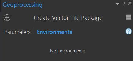
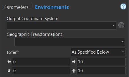
There are no environment settings for Create Vector Tile Index or Create Vector Tile Package. The request is to add an environment setting for extent to these two commands, any features that fall outside of that extent would not be rendered in the vtpk. This would limit the size of the resulting basemap without having to clip all features in a Map.
 Existing Environments
 Suggested Environments
A work-around is to edit the polygons of the Tile Index to only include the smallest tiles and their parents in the area of interest, but this is a cumbersome approach.
Hello emmor nile,
Thank you for submitting this idea. Don't forget to vote for it!
I've removed Explorer and Collector from the categories since this is a request for functionality in Pro while creating vector tile packages.
Could you provide a little more information about the types of projects this would be useful in? You mentioned resulting file size, but are there other issues that arise due to the inability to define an extent?
Thanks Scott
Presently I have a vtpk that represents 64 million polygons and is 1.4GB in size.
Our field foresters use this layer in the field using Collector and we would like to be able to constrain the extent, and thus the size, to their various service areas.
Another use that we are planning on is for wildfire response mapping. We will create an incident specific basemap at least twice a day for fire operations personnel to download and use on the line. We do not need to have the mapped area outside of the fire vicinity and the new tiles need to be as compact as possible.
The limitation of 500mb file size for Collector is what we are trying to meet, and smaller is even better.
Another issue related to extent would be the time required to generate the vtpk files. A large geographic extent can take several hours to generate.
Vector tile packages are great and we appreciate the functionality, thanks.
Emmor
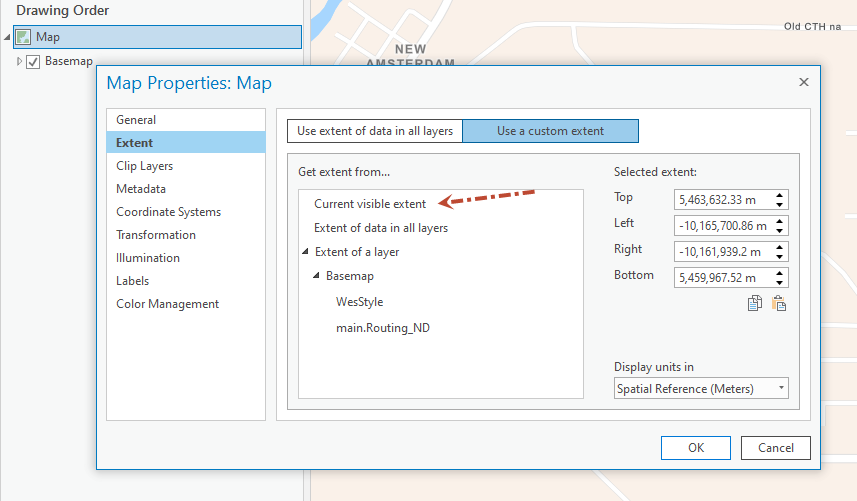
The Create Vector Tile Package will honor the specified extent of the map. So you can define the extent for the map to control the extent of the tiles that get created when you create a vector tile package from the map.

Do You know when the tool will respect the 'Clip Layers' settings? Should I submit a new idea?
@StefanUseldinger, @MarkBockenhauer, @ScottPrindle this needs to be implemented ASAP! I'm having the same issue.
I clipped my map frame (basemap) to a layer (AOI polygon).
Used the "Download Map" button on the ArcPro ribbon... yet when I open the output .vtpk in Pro it appeared to use the extent (bbox) of the poly feature rather than the clipped extent.
Below is the output .vtpk (much bigger area than desired)
I need the .vtpk to only include the basemap tiles that fall within the poly boundaries (honor the clip) like screenshot below.
Is this possible??
I have automated the process described by Mark in this thread and shared my scripts on GitHub for public consumption. The script will automate the creation of vtpks for custom extents (AOIs) and user defined scales. Just fill in the parameters.
It does NOT clip over printed labels. It's been mentioned that you can use mmpk to clip vtpks but I haven't had success with that nor do I want to go through the extraction process every time I need a vtpk. Esri did say they will put in an enhancement for a clip process. II don't know if they will ever get to it.
@EarthJennaThe arcpy.management.CreateVectorTilePackage() GP tool can't process basemap tiles. It returns this "ERROR 001852: Layer type is not supported for vector tile packages." Same for when I try to create an index for my AOI.
I need to export basemap tiles, not vector data.
Thanks though!
You are correct, this code will create the vtpk for a given AOI(s) like the OP @emmornile1was trying to do NOT clip a already processed vtpk. It basically automates what Mark was describing on this thread.
I still need a solution like what you have described. A clip of a processed vtpk for a given AOI. I've explored this in depth and can't solve it with the current offerings from esri. Folks have suggested using a mmpk process, but it didn't work as needed for me.
When figuring out this automation I did work with esri support services and asked for help on the clipping as well because my labels overprint when processed at smaller AOIs. They did not have a clip solution to offer. Manually or in an automated fashion. So, I think as of Halloween 2024 it's not out there BUT highly desired!
@EarthJenna you mentioned having trouble with the .mmpk method... check out this post... I was having an issue where a .vtpk wasn't being outputted into the .mmpk's 'commondata' folder.
Turns out you have to have the basemap .vtpk saved locally and add that to your map frame THEN export to .mmpk with the clip configured... hope this helps.
You must be a registered user to add a comment. If you've already registered, sign in. Otherwise, register and sign in.


