- Home
- :
- All Communities
- :
- Products
- :
- ArcGIS Pro
- :
- ArcGIS Pro Ideas
- :
- Calculating the X and Y coordinate automatically f...
- Subscribe to RSS Feed
- Mark as New
- Mark as Read
- Bookmark
- Follow this Idea
- Printer Friendly Page
Calculating the X and Y coordinate automatically for the point layer
- Mark as New
- Bookmark
- Subscribe
- Mute
- Subscribe to RSS Feed
- Permalink
Calculating the X and Y coordinate automatically for the point layer,
I’m not sure why the ArcGIS does calculate:
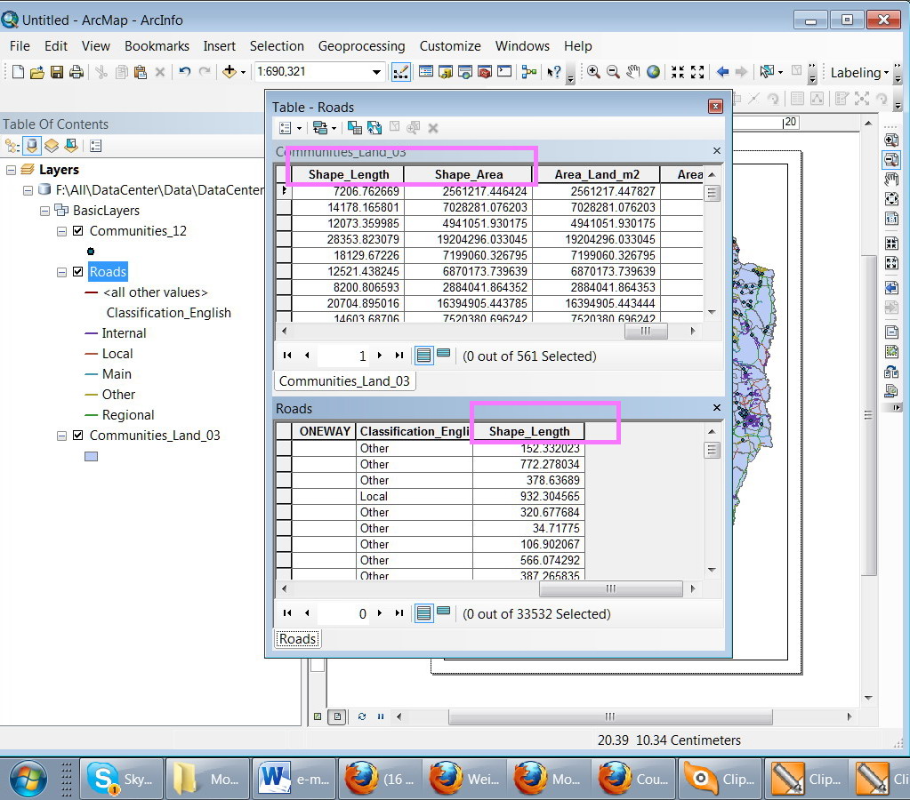
1. The area and parimeter in the polygon layer;
2. The length as a polyline layer
3. BUT doesn’t create the X and Y coordinate in the Point layer
I do know that there is a tool to calculate the XY coordinate, but I’m wondering why they are not calculated by default!!! In this case, for example, if we move one of the points, then we need to manually update its XY coordinates!!!
Is there any logic behind this?
Regards
Jamal
- « Previous
-
- 1
- 2
- Next »
I am aware of the Attribute Assistant, I just think it's rather dumb that this is not a native GDB functionality. If they can do it with Length, Area and Perimeter, they can certainly do it with X & Y centroid. I mean, I could even write a Python Add-In to listen for the onEdit event and update the coordinates for the edited feature on my own, that doesn't mean I should have to.
This is low-hanging fruit, IMHO. Just because something is already possible through a plug-in or extension doesn't mean it shouldn't eventually transition to a native functionality. ET GeoWizards has been able to rename and reorder fields for years (granted it does that by creating a new dataset) but the fact that ET Geowizards exists and can perform that functionality doesn't suddenly let ESRI off the hook for creating that much demanded functionality in the software. I mean, if that's the case then I should probably go ahead and download and install every single plug-in and extension there is for the software. Letting ESRI get by with a fragmented plugin this, extension that, addon here approach results in severe functionality fragmentation.
I always acknowlegde workarounds in my ideas to show that I am aware of them and to tell Esri why the workaround is overly complex, painful, frustrating, or stupid so that they do not dismiss the idea as solved by the workaround. I agree they are not off the hook, because few people go to the lengths I do to workaround their software limitations. But when a workaround exists I want to make sure others are at least aware of them so that they can get something done while Esri ignores this site.
Has this been developed in arcpro 2.4.1?
This is partially implemented through the use of attribute rules and Arcade in ArcGIS Pro.
Set up your X and Y columns as a Double data type and create calculation rules to populate those with the point's geometry.
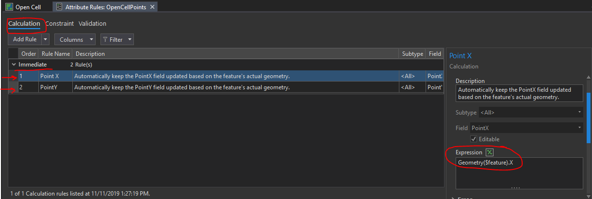
The Arcade expression would look like Geometry($feature).X or Geometry($feature).Y.
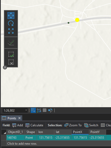
Before I move the point we see that the dynamic PointX and PointY values are the same as the static lon and lat fields:
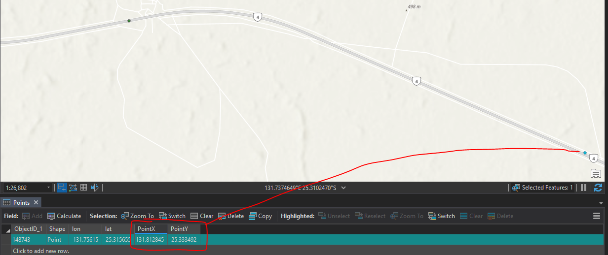
Move the point to the east and see that the PointX and PointY automatically update:
In the attribute table of a point feature class in ArcGIS Pro:
Give users the option to turn on dynamic, read-only columns that represent each feature's X and Y coordinates.
- The fields would have similar properties to that of the SHAPE column in the attribute table.
This would be helpful for day-to-day GIS analysis activities. And would eliminate the need for users to calculate or generate the X and Y columns themselves.
We've shared guidance in this in the comment above: https://community.esri.com/t5/arcgis-pro-ideas/calculating-the-x-and-y-coordinate-automatically-for-...
Sure Kory. We can add the x and y fields and calculate their values with the available tools.
What I wanted here is to have them added and calculated by default the same way the length and area fields are added for polygon layers and dynamically calculated

This idea is Open, but I wanted to share a blog that I wrote recently showing how to do this with Attribute Rules: Get to the Point: Automatically maintain x,y,z attribute values with ArcGIS Pro and attribute rules
Thank you everyone for your contributions to this Idea.
In the coming release of ArcGIS Pro 3.6, Users will have access to a new templated attribute rule geoprocessing tool, Calculate Geometry Properties. This tool may be used to configure fields containing the x and y coordinate geometry information of point features. The rule is configured by default to trigger on insert and on updates to an existing features' shape field.
Having the x and y coordinate automatically populated for all point feature classes is not currently on the roadmap of enhancements for ArcGIS Pro.
You must be a registered user to add a comment. If you've already registered, sign in. Otherwise, register and sign in.