- Home
- :
- All Communities
- :
- Products
- :
- ArcGIS Pro
- :
- ArcGIS Pro Ideas
- :
- ArcGIS Pro Catalog view: Double click on Map to op...
- Subscribe to RSS Feed
- Mark as New
- Mark as Read
- Bookmark
- Follow this Idea
- Printer Friendly Page
ArcGIS Pro Catalog view: Double click on Map to open it
- Mark as New
- Bookmark
- Subscribe
- Mute
- Subscribe to RSS Feed
- Permalink
99.99999999% of the time I open the maps folder in ArcGIS Pro's Catalog view, the very next thing I want to do is open a map. When I double-click on a map object, please make the default action to open it. Showing me a list of layers in it is something I pretty much NEVER need to see, but I end up there at least twice a week while trying to open a map.
NOTE: The Catalog pane (the smaller dockable palette) opens the map via double-click. Can we make the Catalog view do the same thing?
- « Previous
-
- 1
- 2
- Next »
Hi @wayfaringrob ,
Regarding your comment above about what you can do with map layers in a Catalog view... You can’t manage map layers in the Catalog pane or the Catalog view at this time. You can only manage them—copy/paste or drag/drop to a new map—from one map’s Contents pane to another map. This is why we don’t show a map's content anywhere except in the Catalog view.
However, we must be able to show map layers and tables in the Catalog view so that you can view and edit full metadata for them to support specific data publishing workflows. For situations where metadata and publishing are not your primary concern, we will be giving you the option to optionally have the Catalog view work in the same manner as the Catalog pane when you double-click a map.
@NaicongLi This whole interface exists for the sole purpose of metadata? Isn't that accessible within the map?
Hi @wayfaringrob ,
Only a minimal amount of metadata is available in the Properties dialog box for a map, map layers, and tables in a map. However, full standards-based metadata can only be viewed in the Catalog view and edited in the metadata editor. The full range of metadata operations are only available from the Catalog view, including operations like importing an organizational template with standard legal information, synchronizing metadata content with a dataset’s properties, and so on. Besides these metadata related operations, the Catalog view also allows you to review spatial datasets and tables.
Besides these metadata related operations, the Catalog view also allows you to review spatial datasets and tables.
No, this does not seem true.
Hopefully this is implemented soon. I am constantly ending up in this useless window, and it's beyond frustrating.
Hi @wayfaringrob,
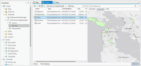
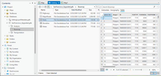
The Geography and Table tabs in the Catalog view are useful for previewing spatial datasets and tables, for example:
Many users find it useful to preview a data item before adding it to a map.
From your screenshots, it seems you were trying to preview map layers, which is not what the current functionality is designed to do. If you would like to preview map layers, please enter a separate idea for it.
Thanks for your feedback.
You must be a registered user to add a comment. If you've already registered, sign in. Otherwise, register and sign in.


