- Home
- :
- All Communities
- :
- Products
- :
- ArcGIS Pro
- :
- ArcGIS Pro Ideas
- :
- Add XYZ Tiles Layer(TMS)
- Subscribe to RSS Feed
- Mark as New
- Mark as Read
- Bookmark
- Follow this Idea
- Printer Friendly Page
- Mark as New
- Bookmark
- Subscribe
- Mute
- Subscribe to RSS Feed
- Permalink
As we know TMS is faster than wms and wmts,but arcgis can't add tms service.
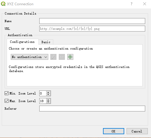
In QGIS,we can easily add tms layer,like this。I think that Esri can add this function to ArcGIS/ArcGIS Pro in the future!
- « Previous
-
- 1
- 2
- Next »
Because it can already be done, pretty much all OGC standards are supported out of the box, and "TMS" layers are supported by the following method, though they have to be defined as a map:
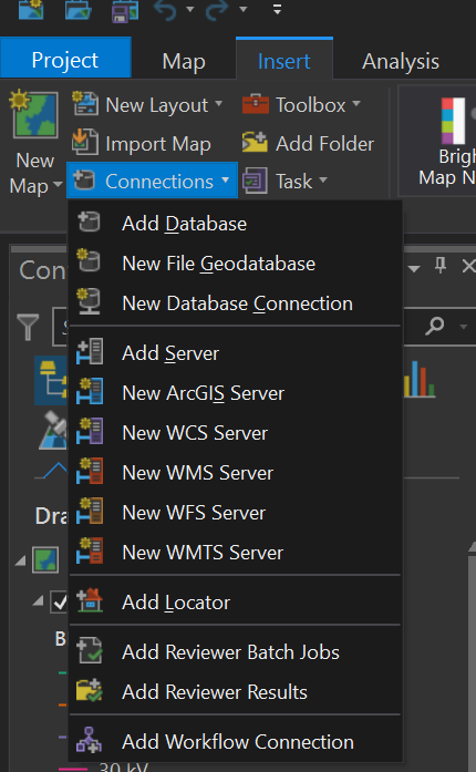
In pro this doesn't work for obvious reasons, TMS not being a true OGC standard, even by standards on the level of the opengeospatial consortium. Instead they defer to WMTS themselves, which is in essence TMS, but with a bit more data regarding CRS, and all that goodness. Per default a TMS would "default" to WGS84 web mercator, whereas with WMTS you'd actually be getting the actual tiling scheme as well. They can be added through the "insert connection" panel, after which the content (eg: tile layers, or XYZ layers) would show up in the respective catalog category:
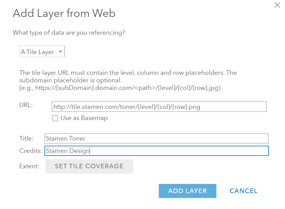
I think that this covers all the bases in an as GIS "integral" way as possible, and if you still have some legacy "XYZ" tile caches lying about or randomly on the internet, well, that also works though again: defined as a map. Such as I just did from the stamen map mentioned above, which looks great in ArcGIS Pro:
First thanks for answering my doubt,but i still don't agree with you.Forgive me for my poor English. I hope you can understand me.
I understand what you say.As you say,I must add it in ArcGIS Online and save map,then add it to arcmap or acrgis pro.Don't you think it's troublesome?
First ,I have to use arcgis online or Portal to add xyz Tiles layers.
Second,then i can add it to my application(arcmap or arcgis pro), I have to do two steps ,it's troublesome。
Third ,I don't think wmts in arcgis is very good,when I add the service to arcgis10.4.1,it will shut down as copmpuer‘s memory grows,maybe in arcgis latest version also has the same problem.
At last,although tms is not a ogc standard,I still think it's import to users, I want to add it wo my AE program exe,I only find ArcBruTile。I Just hope that in the future the users like me can add tms layer to their map easily!I don't want you to tell me that add from arcgisonline,what you say means I have to tell my users that they have to buy portal except ArcEngine,which will cost a lot of money!
I'll second this.
Being required to add xyz layers to AGOL first, and then import them as a basemap is, frankly, ridiculous.
The xyz standard is in use by Google, OSM, and Mapbox, as well as a number of regional providers. We cannot always control what map services we are delivered by our input data sources, but we sure can ask that the vendor support a standard on all their systems, or none at all.
The standard allows for dynamic restyling of the delivered tyles based on url delivered parameters. Want to make roads disappear in google maps, and labels, and make buildings who up only as blue? Sure - you can do that. We don't need to the ability to affect this styling in ArcGIS, but we certainly should be able to add xyz tile layers from major providers without jumping through the hoop of using ArcGIS online.
hello @欢杨,
Adding XYZ tile layer in Pro is supported since 2.6.
All you need to do is to choose 'Map | Add Data | Data From Path' >> paste a url like this (https://tileserver.memomaps.de/tilegen/{level}/{col}/{row}.png) and click OK.

Please see 'Add a dataset from a path' section in https://pro.arcgis.com/en/pro-app/latest/help/mapping/layer-properties/add-layers-to-a-map.htm for more info.
Will this work for you?
Thanks.
Tanu
In the newest update 2.7.3 this feature stops drawing map tiles after level 18. Is there an xml/json file we can put at the root of the url/path that ArcGIS Pro will read to fill the layer metadata, particularly the available zoom levels and bounding box? Anyone else having this issue?
Moved to a new question - https://community.esri.com/t5/arcgis-pro-questions/add-data-from-path-stops-drawing-after-zoom-level...
Public layer is there and you can also use a Carto layer to test.
My company have a XYZ Tiles layer, but it require authentication http request.
How I can add the a custom request header to the tile layer.
I use ArcGIS pro 2.9.0 for now
Thanks.
You must be a registered user to add a comment. If you've already registered, sign in. Otherwise, register and sign in.