- Home
- :
- All Communities
- :
- Products
- :
- ArcGIS Pro
- :
- ArcGIS Pro Ideas
- :
- Add Overview Map to ArcGIS Pro like ArcMap has. A...
- Subscribe to RSS Feed
- Mark as New
- Mark as Read
- Bookmark
- Follow this Idea
- Printer Friendly Page
Add Overview Map to ArcGIS Pro like ArcMap has. ArcMap Equivalence
- Mark as New
- Bookmark
- Subscribe
- Mute
- Subscribe to RSS Feed
- Permalink
In ArcMap, there's a floating Overview Map that shows you the area surrounding your Data View with an extent rectangle showing where you are zoomed. In ArcGIS Pro, we need the same thing, an Overview Map to view the extent of zoom for the Layers tab.
In ArcGIS Pro you can create a linked map view, but you can't add an extent rectangle unless you have a layout. A layout is not needed here. We just need a floating overview map with an extent indicator.
This problem would be improved by enabling any linked map to have an extent rectangle for the map it's linked to. That would not be as easy as it is in ArcMap, but it might be sufficient. To have full ArcMap equivalence, you should have a button/menu-item for the Overview Map that would just pop it up with the extent indicator present.
- « Previous
-
- 1
- 2
- Next »
This would be useful when creating a print service in Pro as I use this functionality for a print service from ArcMap templates.
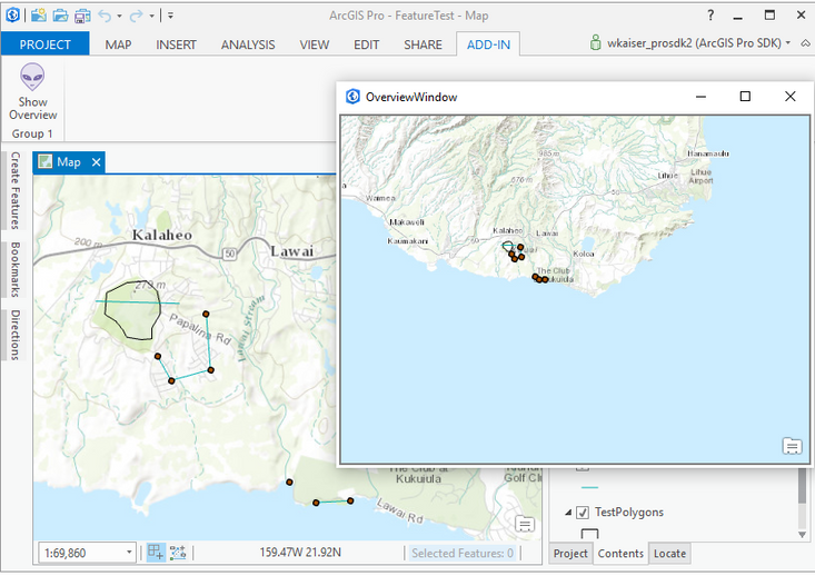
There is already a tool (Overview Window) developed by esri (@Wolf , @UmaHarano ) in pro sdk which does similar functionality. Unfortunately it doesn't have any indicator yet but it's as easy as it is in ArcMap.
Here's the link:
https://github.com/Esri/arcgis-pro-sdk-community-samples/tree/master/Framework/MapControl
you need to use Visual Studio to build the solution and install it.
Cheers
Mehdi
Any chance of implementing this ArcMap Equivalence issue?
It's got lots of kudos.
Here's the ESRI Community Question with more conversation and details on this.
Hi @DavidWheelock2 Have you tried using a floating map view of your same map at a different scale along with the link cursor? I think that in 3.3 that floating view might fall behind the main app. We're doing some work in 3.4 with minimize views that could alleviate that. Just sharing some thoughts as we don't have this as a near-term item right now.
Hey @KoryKramer . Love that floating view in your post. I could not find a way to implement this in 3.3.1. Can you please advise? Thanks.
Hi @KoryKramer.
The linked cursor is a nice feature, but it is not an extent rectangle and does not show the extent of the zoom level of the main map. Also, the "Overview Map" should not recenter every time you pan the map that it's linked to. It should have a fixed extent or it should allow the option of either centering or not centering.
If ESRI is determined not to provide the same basic ease-of-use and functionality, a one-button solution like ArcMap has, then perhaps it could expand the features of the linked map to do the same thing.
So specifically, to make the linked map work like an ArcMap Overview Map it should:
- Provide an extent rectangle in the linked map showing the zoom level of the main map.
- Enable the linked map to either not pan or to pan, that is, to allow a fixed extent.
Your thoughts?
@ArcGIS_OnlineAdmin you can float any view by grabbing its tab and dragging it (to undock it) and then placing it where you want and resizing. More here https://pro.arcgis.com/en/pro-app/latest/get-started/get-started.htm#ESRI_SECTION2_3B550887DFFF46718...
I've been using ArcGIS Pro since 2016 and I use floating maps all the time. That's not what we're talking about here.
Please review my comments above about the current functionality could be improved to be equivalent of the ArcMap Overview Map.
You must be a registered user to add a comment. If you've already registered, sign in. Otherwise, register and sign in.


