- Home
- :
- All Communities
- :
- Products
- :
- ArcGIS Pro
- :
- ArcGIS Pro Ideas
- :
- Ability to edit single pixels of a raster dataset
- Subscribe to RSS Feed
- Mark as New
- Mark as Read
- Bookmark
- Follow this Idea
- Printer Friendly Page
Ability to edit single pixels of a raster dataset
- Mark as New
- Bookmark
- Subscribe
- Mute
- Subscribe to RSS Feed
- Permalink
To Change the pixel value in ArcGIS 10. Is it possible to edit the values of pixel of an image RGB? For example: I select a pixel with value 3,44,125 and want to modify it for 0,0,255
By other hand, I apologize because I posted the idea wrong I did a question but is it a idea.
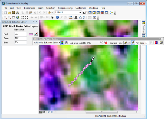
This can be done with the latest version of the "Grid & Raster Editor for ArcMap". It supports many editable single and multi-band rasters in ArcGIS. The toolbar provides a set of tools to change the value of one or more cells. With these tools it is possible to:
- draw a free line or edit single cells (pencil)
- draw straight lines from one point to another (line)
- draw a solid polygon (polygon)
- change the value/color of a zone of cells with identical values (paintcan)
- replace one value with another value in the entire grid (value replacer)
- create a selection area in the map to limit the working area for the above operations (edit area)
Available for ArcGIS 10.0 - 10.8 on https://www.aris.nl/gridrastereditor_arcmap
paloma.sanchezesri-es-esridist Does the ARIS Grid and Raster Editor for ArcMap allow you to do what you were asking?
You must be a registered user to add a comment. If you've already registered, sign in. Otherwise, register and sign in.