- Home
- :
- All Communities
- :
- Products
- :
- ArcGIS Parcel Fabric
- :
- ArcGIS Parcel Fabric Ideas
- :
- COGO Traverse Tool Adjustment Residuals
- Subscribe to RSS Feed
- Mark as New
- Mark as Read
- Bookmark
- Follow this Idea
- Printer Friendly Page
COGO Traverse Tool Adjustment Residuals
- Mark as New
- Bookmark
- Subscribe
- Mute
- Subscribe to RSS Feed
- Permalink
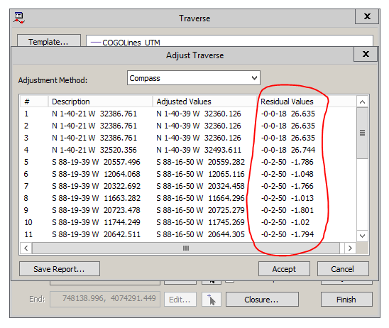
In ArcMap when entering a traverse that doesn't close you could use an adjustment that would return a report of residuals or delta values of how much each bearing and distance changed. This was a key part of the tool. In ArcPro you get an overall closure value (which was also available in ArcMap) but no residual values.
My main use of the traverse adjustment has always been for analysis of survey data outside of the parcel fabric. I routinely use it analyze old metes and bounds descriptions to determine misclosure. And then using the misclosure and the residual values (which have also been removed from Pro) I can find the most likely source of the error. Then I can go back to the record and potentially other data sources to try resolve the error. Often this will include trying this will multiple adjustment types. If you are familiar with adjustments you can external use external knowledge (era of the survey, the surveyor's habits, the equipment used to collect the data, the geography and topography of the land, comments about weather and clarity of the sky during astral observations, etc) to adjust the most likely source of error and get the best adjustment result possible.
The residual values created during the adjustment process are key to this whole process. Without the underlying data to look at and analyze none of the adjustments are really that useful for anything but making a figure close and cartographically look okay.
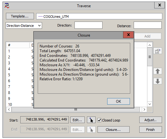
Also the closure information has also been cut down from what was in ArcMap to what is in ArcPro. It doesn't even show grid closure vs. ground closure anymore.
Traverse Adjust window with residuals
Closure report window
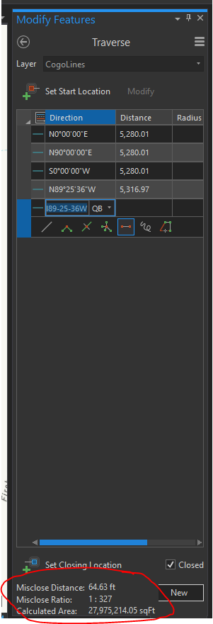
ArcPro Traverse tool
- « Previous
-
- 1
- 2
- Next »
Also check out this related topic on including more adjustment types (compass rule, transit, crandall, grant boundary, etc)
idea: Wouldn't it be better to have the residuals reported as graphics / labels on the map using an appropriate symbology?
How about both? Having the ability to highlight the line by selecting the residue from a report has the potential to help the user.
I agree with Jonathan. Why not have both? Both could be very useful.
Looping Daniel Stone and Amy Andis
Least Squares Adjustment in consistency Check mode can do a much better job to detect blunders and outliers for a given traverse. Would launching LSA from the traverse be better?
We also plan to have new Quality Layers to help detect COGO issues in the Near Term.
If the motivation is purely cartographic, we also have some ideas in that area to improve co-linearity (tangency) and orthogonality.
Having seen the implementation of LSA now I would agree that for those who are working within the fabric the LSA is the better option for detecting blunders and outliers.
For those outside the fabric and therefore don't have access to LSA. The requested features would still be extremely valuable. Within our organization we have about 5,000 users who are not in a fabric and only about 15 who are (for one particular dataset and are outside of the fabric for the rest of their work).
Good point about the other 5000 users Lucas.
Are they the type of users that do not use the traverse tool frequently?
Are they surveyors like yourself? do they only use the residual to try to catch errors? I ask because if the data is homogeneous long courses will have bigger residuals in distance and shorter courses are likely to have bigger residuals in direction.
Some are surveyors as well, though many are in mining, lands and realty, resources, etc and are used to working with maps, plats, and metes and bounds descriptions. They use the traverse tool frequently to enter mining claims and legal descriptions into GIS.
So what you say is true about compass rule adjustments, but other adjustment types have different weights and which can provide different residuals. So for me this is yet another reason to have multiple adjustment types.
I'm sure there are many people who use this on a regular basis and have built this information into their daily workflows. It seems strange to suddenly take this (and the ability to use different adjustments) away in a new improved software that's supposed to better in every way. Without these options the traverse tool in Pro is worse despite the improvements that have been made.
I'd also like to say the residuals are important but the rest of the closure window in ArcMap that's not available in Pro is also important. There's a lot of good information there that we no longer have access to: Total length of travers, calculated end coordinates, end coordinate, and misclose X and Y (something I use a lot).
BTW. I'm arguing for having access to the residuals. How they are displayed whether it's in a table or graphically using a color scheme on the lines or labels with the residuals doesn't really matter that much to me. I would be able to get used to whatever the new system is for this.
Thanks for the input Lucas
Sorry to get on my soapbox here but I spend more time in this tool than any other whether I'm in the fabric or not.
You must be a registered user to add a comment. If you've already registered, sign in. Otherwise, register and sign in.