- Home
- :
- All Communities
- :
- Products
- :
- ArcGIS Online
- :
- ArcGIS Online Questions
- :
- Re: Uploading pictures in ARC GIS Online
- Subscribe to RSS Feed
- Mark Topic as New
- Mark Topic as Read
- Float this Topic for Current User
- Bookmark
- Subscribe
- Mute
- Printer Friendly Page
- Mark as New
- Bookmark
- Subscribe
- Mute
- Subscribe to RSS Feed
- Permalink
If I want to associate a picture for each point in a layer how do I do that? I think I need to generate a link for each image and add it as an attribute then plugin that information in the configurable pop-up menu but I'm not sure where to generate the URL for the image. I know I can do it within our Organization site in ARCGIS online but that seems to be a lengthy process .
We are going to be using the story map - photo tour apps within our Organization and I am trying to learn as much as possible about how things work. If anyone has any good resource information I'd welcome it.
Thanks,
Natasha
GIS tech at African Wildlife Foundation
Solved! Go to Solution.
Accepted Solutions
- Mark as New
- Bookmark
- Subscribe
- Mute
- Subscribe to RSS Feed
- Permalink
Can you provide more background on the images you plan to use? Are these images you are collecting in the field (i.e. using Collector for ArcGIS), or are they images you have hosted on your local server?
If the images are stored on your server (or another server), when editing the point in a web map, you will have the option to add an attachment:
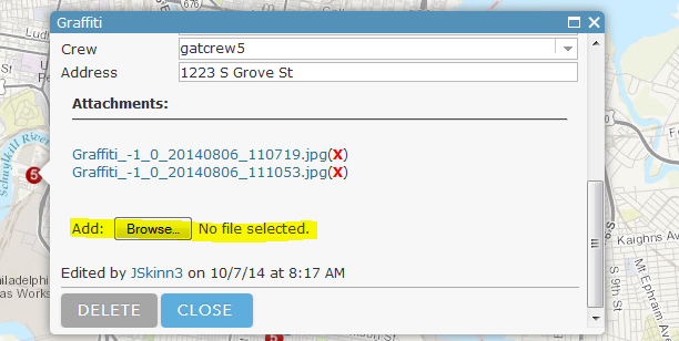
You will then have a link to view the image in the pop-up:
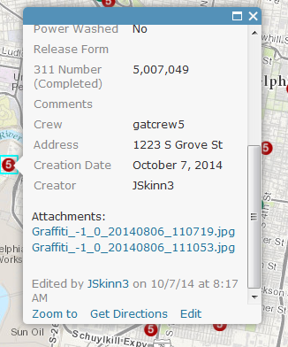
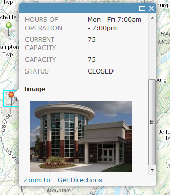
If you have the image hosted on a web server, you add a text field to the feature service and populate the URL to the image. See the section 'Show Images' in the below link:
http://doc.arcgis.com/en/arcgis-online/create-maps/configure-pop-ups.htm
You can then view the image directly in the pop-up. Ex:
- Mark as New
- Bookmark
- Subscribe
- Mute
- Subscribe to RSS Feed
- Permalink
Hi Natasha,
You can enable attachments for your feature service. You can then add an attachment(s) for your feature upon editing. You can then access the URL to the attachments using the REST URL including the following '/7/attachments', where 7 would be the OBJECTID of the feature. For example:
This will return the attachments for the feature with an OBJECTID of 7.
- Mark as New
- Bookmark
- Subscribe
- Mute
- Subscribe to RSS Feed
- Permalink
Jake the above link is disabled and I'm unclear still as to the best way to
1. Create a URL for an image and 2. Add a different image to a pop-up for
each point, line, or polygon in a vector file.
I'm new to the online platform but we will be using our account more over
the next year so I need to learn how to do these things. If you have any
good recommendations for tutorials associated with webmapping in ARCGIS
online I would appreciate it.
So just to recap: If I have a layer with 20 points I want to add an image
to each point as a pop-up in a web-map. How do I facilitate this? Where do
I get a URL for the images? Then how do I add them to each point? I see
that I can add one popu-up for each layer but that's not what I need.
Thankyou,
Natasha
- Mark as New
- Bookmark
- Subscribe
- Mute
- Subscribe to RSS Feed
- Permalink
Can you provide more background on the images you plan to use? Are these images you are collecting in the field (i.e. using Collector for ArcGIS), or are they images you have hosted on your local server?
If the images are stored on your server (or another server), when editing the point in a web map, you will have the option to add an attachment:
You will then have a link to view the image in the pop-up:
If you have the image hosted on a web server, you add a text field to the feature service and populate the URL to the image. See the section 'Show Images' in the below link:
http://doc.arcgis.com/en/arcgis-online/create-maps/configure-pop-ups.htm
You can then view the image directly in the pop-up. Ex:
- Mark as New
- Bookmark
- Subscribe
- Mute
- Subscribe to RSS Feed
- Permalink
Jake thanks for the time in trying to help me.
Right now the images are housed in our media-kit and don't have any URL
associated with any of them. I know I can bring them into our Organization
account, share them and get a URL that way but is there any other way to do
this? Also, the points I'm talking about already exist in a .shp so they
aren't being added to the webmap as map notes.
In the attachment I simply added a point on the map and pasted a link to a
shared image into the option but the image doesn't appear in the pop-up,
just the URL. So the user has to click on the link?
I'm going to explore a bit and through trial and error it'll get done.
I'll keep this thread so I can make more specific questions if I have them.
- Mark as New
- Bookmark
- Subscribe
- Mute
- Subscribe to RSS Feed
- Permalink
You would need to enable attachments. Do this in the ArcGIS Online "My Content" interface is it's a hosted service. (Layer details ->Edit)
-OR-
If it's hosted on your own ArcGIS Server, use ArcGIS Catalog to Enable attachments on the Feature Class itself. this will create a Table and a Relationship class so be sure the suer you're connecting to has Edit permissions for SDE.
- Mark as New
- Bookmark
- Subscribe
- Mute
- Subscribe to RSS Feed
- Permalink
See my first response. Their is a hyperlink there that provides a help link on how to enable attachments.