- Home
- :
- All Communities
- :
- Products
- :
- ArcGIS Online
- :
- ArcGIS Online Questions
- :
- Stretched image color ramp display issue
- Subscribe to RSS Feed
- Mark Topic as New
- Mark Topic as Read
- Float this Topic for Current User
- Bookmark
- Subscribe
- Mute
- Printer Friendly Page
Stretched image color ramp display issue
- Mark as New
- Bookmark
- Subscribe
- Mute
- Subscribe to RSS Feed
- Permalink
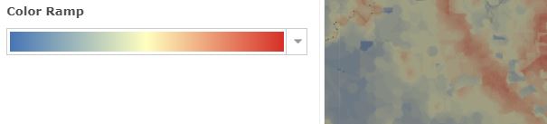
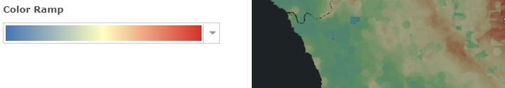
I'm having a problem with the display of an image layer in ArcGIS Online. The layer is a reference to a REST service of a DEM (image mosaic) from our state's GIS office. I have it set to display with a stretch symbology, min/max, and an elevation color ramp. It is also set to dynamically adjust the range. Sometimes it works just fine, but more often the color ramp has a strange stepped characteristic (note the display of the color ramp in the attached screenshot - it should be as shown in the second attachment (ElevationColorRamp)) and the ramp is also reversed - the white is the lowest elevation while the blue is the highest.
Another issue is that it often stops displaying at all - particularly as I've been trying to troubleshoot.
Does anyone even have any ideas about what is causing this?
Thanks!
- Mark as New
- Bookmark
- Subscribe
- Mute
- Subscribe to RSS Feed
- Permalink
Just out of curiosity did you ever find out why this was happening to the image layer? I have similar things happening to an image layer that is set to stretch and min/max being used in a web map and application. In addition to it reversing the color ramp when zooming in and panning it is also displaying different colors in Portal versus ArcGIS Online when using the same color ramp. For example I chose a blue to red color ramp but green is showing up on the map in ArcGIS Online. We are also having an issue with another feature layer's symbology changing when we use the editing widget, not sure if that is related to the problems we are having with the image layer.
Thanks,
- K
- Mark as New
- Bookmark
- Subscribe
- Mute
- Subscribe to RSS Feed
- Permalink
No, I haven't had any success figuring this out or gotten any assistance.
The only additional info I can offer is that I found out from the state GIS office that the service is slowed due to increased demand (they're also hosting information related to the pandemic.) I think that may be why I sometimes don't get any image - I suspect the request times out - but I don't know whether that is impacting the color ramp display. And I'm using a state-wide image layer, so I've wondered whether some of the problem is that it's such a large data set. Can you try using a smaller source file? I know the issue began appearing well before the pandemic (so I don't think it's just that the data source is slow,) but it seems to have gotten progressively worse. I'm not sure we ever get the correct appearance any more. If I remember correctly, I did determine that sticking with the black to white default behaved as it should - but I have users that want to show it to clients and that gradation is not visually obvious enough.
Good luck, and if you figure anything out, I'd love to hear about it!
Greg
- Mark as New
- Bookmark
- Subscribe
- Mute
- Subscribe to RSS Feed
- Permalink
I just got off a call with ESRI and showed them the behavior. I have an analyst working it. I think it might be a bug. Greg are you using Pro 2.5.2 to publish?
- Mark as New
- Bookmark
- Subscribe
- Mute
- Subscribe to RSS Feed
- Permalink
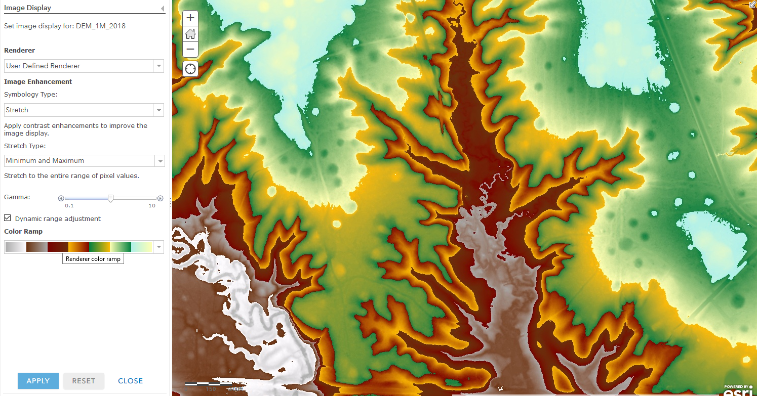
No, this is a layer created in ArcGIS Online as a reference to the URL of an image service layer published by our state GIS office. And I have no idea what they used, but it was published in September 2018 so I don't think it was ArcGIS Pro 2.5. Here's the REST endpoint: gis dot arkansas period gov slash arcgis slash rest/services/ImageServices/DEM_1M_2018/ImageServer
Greg
- Mark as New
- Bookmark
- Subscribe
- Mute
- Subscribe to RSS Feed
- Permalink
ESRI has logged this as a BUG and is working on it.
- BUG-000132637: The color ramp on an image service changes when scale is changed in ArcGIS Enterprise portal map viewer
- Mark as New
- Bookmark
- Subscribe
- Mute
- Subscribe to RSS Feed
- Permalink
yep, and no updates about this issue
- Mark as New
- Bookmark
- Subscribe
- Mute
- Subscribe to RSS Feed
- Permalink
Has there been any updates on this issue. I'm experiencing the same behavior... four years later.
I would expect that the legend (Min / Max) updates when the map extents change.


The functionality that I am looking for works perfectly in ArcGIS Pro.


Is this kind of functionality even possible in ArcGIS Online?