- Home
- :
- All Communities
- :
- Products
- :
- ArcGIS Online
- :
- ArcGIS Online Questions
- :
- Re: Spatial Reference Undefined in 10.2.2
- Subscribe to RSS Feed
- Mark Topic as New
- Mark Topic as Read
- Float this Topic for Current User
- Bookmark
- Subscribe
- Mute
- Printer Friendly Page
Spatial Reference Undefined in 10.2.2
- Mark as New
- Bookmark
- Subscribe
- Mute
- Subscribe to RSS Feed
- Permalink
Hi,
My intention is to georeference an image so as to create a Swipe Map in AGOL. First, I add my control points, rectify, then analyze before attempting to share and finally publish in AGOL. The other day I ran through these steps and it worked fine. I was able to then create the app for a simple Swipe Map. Using the same steps while adding another image to the same map back in Desktop I now continually get the spatial reference undefined error when analyzing. Or the newly created projection through rectifying just disappears and I have to add the control points all over again.
I've added some screenshots.
Thanks for any help.
-Jared
- Mark as New
- Bookmark
- Subscribe
- Mute
- Subscribe to RSS Feed
- Permalink
They aren't georeferenced to anything except the screen(?) since the upper left coordinate is 0,0. Are you sure that the inputs had a coordinate system in the first place?
- Mark as New
- Bookmark
- Subscribe
- Mute
- Subscribe to RSS Feed
- Permalink
Hi Dan,
I georeferenced the images to the basemap and it gave them WGS 84, the same GCS the data frame has.
The top of the two attached sceenshots shows the message I got after georeferencing and rectifying the image. I checked in the layer's properties tab to make sure it had a GCS and it did, WGS 84. And when analyzing in the Tile Package menu it still gave me this error?
The bottom of the two attachments shows when I attempted to georeference another image. I georeferenced Wesley Tnsp first and it took on WGS 84. When I georeferenced Wilmington1870 Wesley was gone and so was it's GCS. I had to add all the control points all over again and GCS disappears again when trying to analyze it, and so on and so forth over again..
- Mark as New
- Bookmark
- Subscribe
- Mute
- Subscribe to RSS Feed
- Permalink
So just to clarify, you already ran through all these steps and it worked, and that work still exists and is successfully georectified? Is that correct? If so, can you use the previously georectified image to georeference this one to?
- Mark as New
- Bookmark
- Subscribe
- Mute
- Subscribe to RSS Feed
- Permalink
Sephe,
Yes, at first I ran through these steps and everything was fine, all the way up to final step of creating the web app (swipe map). Maybe it was a glitch but after trying on another image, using the same process, the GCS would be there one minute and gone the next.
I actually deleted the tile package from AGOL now to start all over. So, the whole web app is discontinued for now- until I get passed this glitch.
- Mark as New
- Bookmark
- Subscribe
- Mute
- Subscribe to RSS Feed
- Permalink
Hi Jared,
Take a look at the check-points:
- Before adding image to ArcMap, define the spatial reference of the image in ArcCatalog (Image properties) itself.
- After georeferencing an image, click "Update Georeferencing"
- When a new image (with defined spatial reference) is addedto the data frame, make sure that the image name in the georeferencing toolbar is pointing to the newly added image.
Think Location
- Mark as New
- Bookmark
- Subscribe
- Mute
- Subscribe to RSS Feed
- Permalink
Hi Jayanta,
I attempted defining the spatial reference in ArcCatalog and in ArcToolbox. It gave me this message: 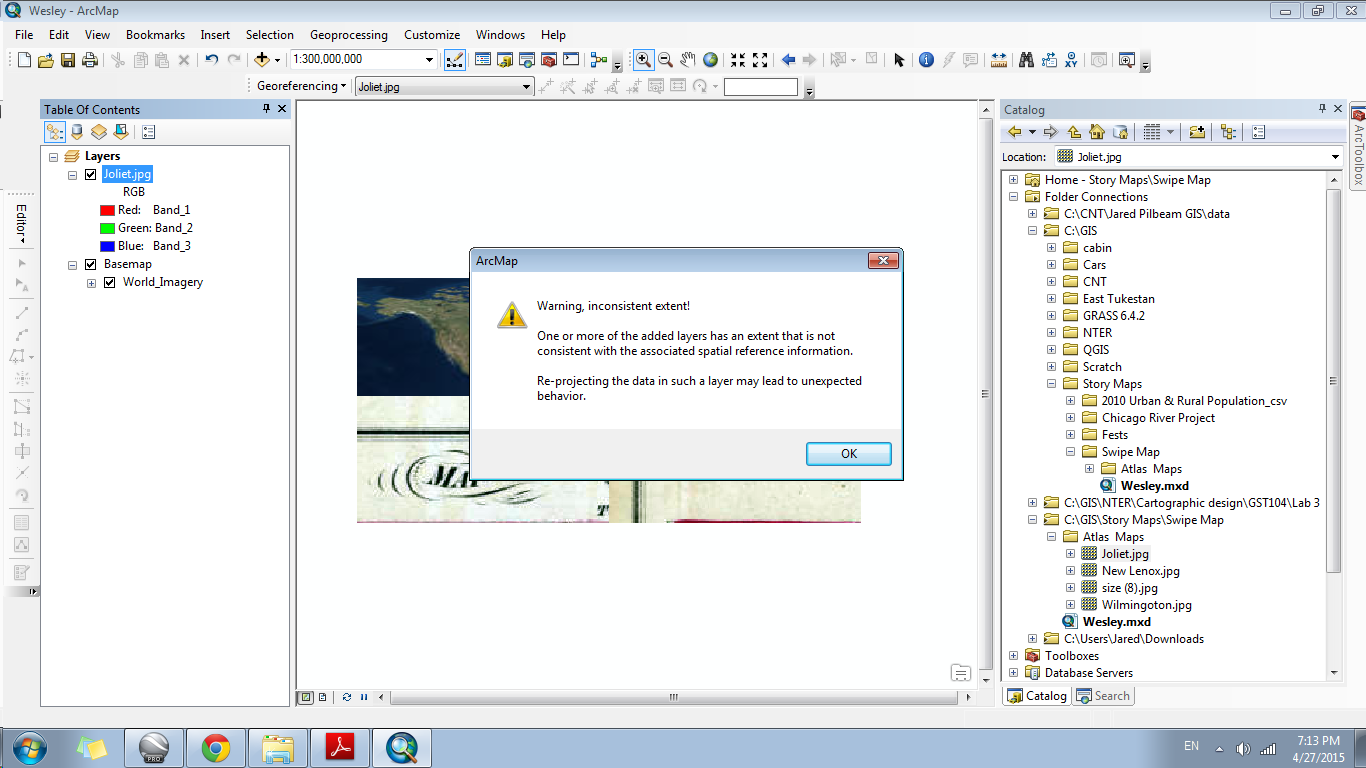
- Mark as New
- Bookmark
- Subscribe
- Mute
- Subscribe to RSS Feed
- Permalink
This was also a clean image. As in, I downloaded it again from the website, so it didn't have any orientation to ArcMap.
- Mark as New
- Bookmark
- Subscribe
- Mute
- Subscribe to RSS Feed
- Permalink
have you gone through this section on Georeferencing a raster ?
- Mark as New
- Bookmark
- Subscribe
- Mute
- Subscribe to RSS Feed
- Permalink
The warning is fine, since the raw image can have any extent irrespective of the spatial reference. This is where you start georeferencing.
Think Location