- Home
- :
- All Communities
- :
- Products
- :
- ArcGIS Online
- :
- ArcGIS Online Questions
- :
- Re: Shift between my published services and ArcGIS...
- Subscribe to RSS Feed
- Mark Topic as New
- Mark Topic as Read
- Float this Topic for Current User
- Bookmark
- Subscribe
- Mute
- Printer Friendly Page
Shift between my published services and ArcGIS Online Base Maps
- Mark as New
- Bookmark
- Subscribe
- Mute
- Subscribe to RSS Feed
- Permalink
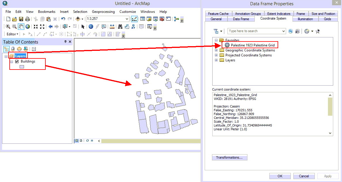
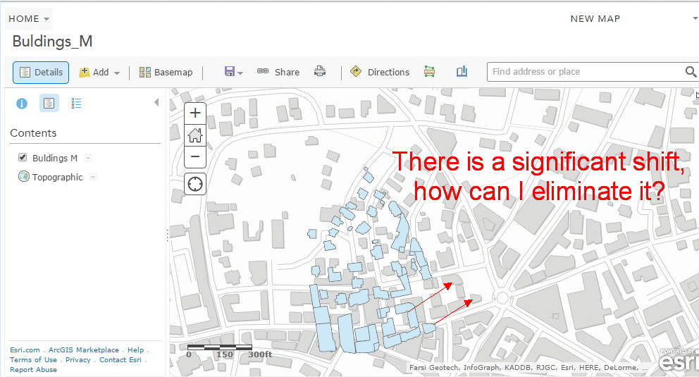
I have a map that contains a layer in “Palestine 1923 Grid WKID= 28191”, when publishing this map via ArcGIS online and adding it to an ArcGIS online map, the layer of the map service is shifted from the ArcGIS online base map.
The same thing happens with services published by ArcGIS Server!
This is better illustrated with the screenshots below
How can I publish my services and add them to ArcGIS online maps with no shifts between them and ArcGIS online base maps?
Note: The coordinates of the features in the layer are accurate and have been verified by an accurate GPS
Any help is appreciated,
Hani
1- The map in ArcMap
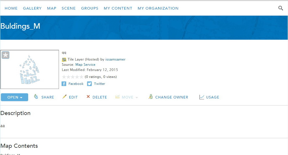
2- The map is published as ArcGIS online service
3- This ArcGIS Online service is added to the ArcGIS online map, and there is a shift between it and the imagery base map.
Solved! Go to Solution.
Accepted Solutions
- Mark as New
- Bookmark
- Subscribe
- Mute
- Subscribe to RSS Feed
- Permalink
Hi Hani,
The basemap in ArcGIS Online sets the projection for the webmap. If you are using an out of the box basemap provided by Esri, then the projection of your web map will be Web Mercator Auxiliary Sphere. If your data needs to be transformed in order to display correctly in the Web Mercator Auxiliary Sphere then please perform the correct projections and transformations prior to publishing.
You can also create a tiled basemap in the projection that your data is in and set it as a basemap. This will ensure that all data in the web map is the same projection as your basemap and your data will line up.
Here is some documentation regarding Basemaps in ArcGIS Online:
Designing Map to Overlay with ArcGIS Online, Google Maps and Bing Maps
Cheers,
Kelly
- Mark as New
- Bookmark
- Subscribe
- Mute
- Subscribe to RSS Feed
- Permalink
There might be something weird going on when ArcGIS Online re-projects your data to fit to its coordinate system.
Have you tried doing that yourself before you publish it? ArcGIS Online uses WGS 1984 Web Mercator (auxiliary sphere).
Hope this helps!
Tim
- Mark as New
- Bookmark
- Subscribe
- Mute
- Subscribe to RSS Feed
- Permalink
Many Thanks for the prompt contribution Tim,
Do you mean that I should project all my layers into AGOL Coordinate system (WGS 1984 Web Mercator (auxiliary sphere)), before plugging them into AGOL maps or apps?
Thank you again,
Hani
- Mark as New
- Bookmark
- Subscribe
- Mute
- Subscribe to RSS Feed
- Permalink
Hi Hani,
The basemap in ArcGIS Online sets the projection for the webmap. If you are using an out of the box basemap provided by Esri, then the projection of your web map will be Web Mercator Auxiliary Sphere. If your data needs to be transformed in order to display correctly in the Web Mercator Auxiliary Sphere then please perform the correct projections and transformations prior to publishing.
You can also create a tiled basemap in the projection that your data is in and set it as a basemap. This will ensure that all data in the web map is the same projection as your basemap and your data will line up.
Here is some documentation regarding Basemaps in ArcGIS Online:
Designing Map to Overlay with ArcGIS Online, Google Maps and Bing Maps
Cheers,
Kelly
- Mark as New
- Bookmark
- Subscribe
- Mute
- Subscribe to RSS Feed
- Permalink
Many Thanks for the suggestions Kelly,
I used my own basemap, and this solved the problem!
- Mark as New
- Bookmark
- Subscribe
- Mute
- Subscribe to RSS Feed
- Permalink
Hi Kelly,
Does this mean that if our data is in a datum like NAD 1983 HARN, we need to select a transformation in the ArcMap Document before publishing or that ArcMap will automatically select one when we bring the data in? This page https://enterprise.arcgis.com/en/server/latest/publish-services/linux/author-feature-services.htm
claims a transformation will automatically be performed if one is not selected, but when I look at the 'Transformations' box in the data frame properties, it reads 'None'. I want to be sure I am testing my GNSS units against control points properly.
Thanks,
Mitch
- Mark as New
- Bookmark
- Subscribe
- Mute
- Subscribe to RSS Feed
- Permalink
I have a similar problem with portal. Did you find a solution?
- Mark as New
- Bookmark
- Subscribe
- Mute
- Subscribe to RSS Feed
- Permalink
DeShawn,
Up to now, I did not resolve this problem, I'll keep you posted with any updates
Thank you
- Mark as New
- Bookmark
- Subscribe
- Mute
- Subscribe to RSS Feed
- Permalink
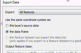
Try changing your dataframe in Desktop to WGS 1984 Web Mercator (auxiliary sphere) and export your feature class to a shapefile or FileGDB, be sure to click "The data frame" when the export window opens. Then open a new .mxd and bring the exported file in so both the feature and the dataframe are set WGS 1984 Web Mercator (aux sphere) and publish the service from there.
- Mark as New
- Bookmark
- Subscribe
- Mute
- Subscribe to RSS Feed
- Permalink
My issues is related to BUG-000085331
DeShawn J. Robins
*City of Champaign | ITD | GIS Analyst *
102 N NEIL ST | 3rd Floor | Champaign, IL 61820
Office: 217.403-8970 | Fax: 217.403.8993