- Home
- :
- All Communities
- :
- Products
- :
- ArcGIS Online
- :
- ArcGIS Online Questions
- :
- Re: Shapefiles and hosted service features don't a...
- Subscribe to RSS Feed
- Mark Topic as New
- Mark Topic as Read
- Float this Topic for Current User
- Bookmark
- Subscribe
- Mute
- Printer Friendly Page
Shapefiles and hosted service features don't align in AGO
- Mark as New
- Bookmark
- Subscribe
- Mute
- Subscribe to RSS Feed
- Permalink
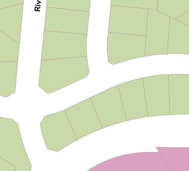
No datasets were reprojected into the WGS84 Web Mercator Auxiliary Sphere prior to uploading or adding, yet all hosted features align perfectly with each other while added shapefiles will not.
Even stranger, the parcel tiles do not align with the parcel features, even though both were created and uploaded at the same time.
Thanks for any thoughts.
[ATTACH=CONFIG]31711[/ATTACH]
- Mark as New
- Bookmark
- Subscribe
- Mute
- Subscribe to RSS Feed
- Permalink
- Mark as New
- Bookmark
- Subscribe
- Mute
- Subscribe to RSS Feed
- Permalink
Has anyone run into this issue, where local shapefile features won't line up with hosted features, all using the same projection/coordinate system in ArcGIS Online maps?
- Mark as New
- Bookmark
- Subscribe
- Mute
- Subscribe to RSS Feed
- Permalink
When you load a shapefile directly into the web map, by default the data gets generalized, unless you choose the option to not generalize the data.
When you add a shapefile to My Content and publish hosted features from it, all the vertices of the data are loaded into the database. However, clients can draw the data in a generalized form. For example, the JavaScript API, upon which the ArcGIS.com map viewer is built does generalize the data. This is done for performance reasons. It reduces load both on the server and client. If the layer is editable, however, no generalization is done.
Tiled map images will accurately reflect the original data. No generalization is performed when tiles are generated from the data.
Hope this helps explain things. I guess what you could try to verify this is when you add your shapefile to the map, choose the option that doesn't generalize. Then, for your hosted features, make the layer editable. In this instance, all the data should align perfectly. If it doesn't perhaps you can send us your shapefile so we can reproduce the problem.
Thanks,
Mike
- Mark as New
- Bookmark
- Subscribe
- Mute
- Subscribe to RSS Feed
- Permalink
- Mark as New
- Bookmark
- Subscribe
- Mute
- Subscribe to RSS Feed
- Permalink
- Mark as New
- Bookmark
- Subscribe
- Mute
- Subscribe to RSS Feed
- Permalink
It seems I'm missing some data to compare...the parcels. Do you have that in shapefile form?
Thanks,
Mike
- Mark as New
- Bookmark
- Subscribe
- Mute
- Subscribe to RSS Feed
- Permalink
Sorry Mike, haven't been back here for a while. I could attach a parcel shapefile, but I can tell you it will match the landscape shapefile perfectly as it does below.. the landscape shapefile was built by copying the parcels in ArcMap so they would align, which they do.
- Mark as New
- Bookmark
- Subscribe
- Mute
- Subscribe to RSS Feed
- Permalink
When you add a shapefile to My Content and publish hosted features from it, all the vertices of the data are loaded into the database. However, clients can draw the data in a generalized form. For example, the JavaScript API, upon which the ArcGIS.com map viewer is built does generalize the data.
Sorry to hi-jack this thread - I think the issue I'm experiencing is slightly different to Dan's - but Mike's statement definitely offers a clue as to my problem.
Hopefully I can get the screenshots to upload - the example below shows how 2 adjacent polygons in a feature class looks in ArcMap. I have carried out a topological check in ArcMap and they appear to be topologically correct, with no gaps or overlaps.
[ATTACH=CONFIG]32384[/ATTACH]
Having uploaded that shapefile to My Content in AGOL and created a feature service from it, it displays in the map viewer thus:
[ATTACH=CONFIG]32383[/ATTACH]
Does the generalisation in the AGOL map viewer occur independently on individual polygons, even if the polygons are within the same feature service and are adjacent and share common boundaries?
- Mark as New
- Bookmark
- Subscribe
- Mute
- Subscribe to RSS Feed
- Permalink
I'm experiencing a similar issue, although the polygons are from separate layers. I now use only hosted features to avoid the misalignments the triggered this thread, but there are still generalizations in the map viewer that cause previously aligned boundaries to not align perfectly. I have a parcel feature service with zoning and city limit feature services which should align perfectly, but instead they meander somewhat like your examples. And for some reason the far smaller datasets of zoning and city limit are much more generalized than my parcel features. Just don't get it.