- Home
- :
- All Communities
- :
- Products
- :
- ArcGIS Online
- :
- ArcGIS Online Questions
- :
- Interpolating arcgisonline vs ArcGIS Spatial Analy...
- Subscribe to RSS Feed
- Mark Topic as New
- Mark Topic as Read
- Float this Topic for Current User
- Bookmark
- Subscribe
- Mute
- Printer Friendly Page
Interpolating arcgisonline vs ArcGIS Spatial Analysis
- Mark as New
- Bookmark
- Subscribe
- Mute
- Subscribe to RSS Feed
- Permalink
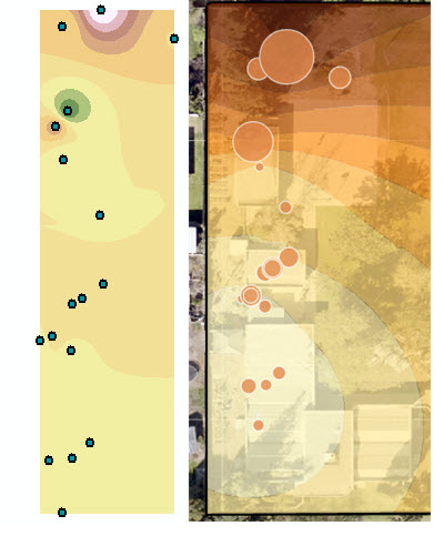
wondering if there is a way to have better results in the interpolating arcgisonline as I do with the IDW using Spatial Analysis .. the image below shows the interpolating using ArcGIS Spatial Analysis and on the right, the output from analysis interpolate arcgis online?
- Mark as New
- Bookmark
- Subscribe
- Mute
- Subscribe to RSS Feed
- Permalink
Thank you for this feedback. As others have noted, Interpolate Points does not use IDW for the interpolation. Instead, it uses Empirical Bayesian Kriging (EBK), which we consider to be our best automatic interpolation method.
We will add extra information about the particular EBK settings that are used in Interpolate Points to the REST API documentation in the near future, but for now, this is what you need to know. Most parameters from EBK are controlled by the "Optimize for" parameter in Interpolate Points. This parameter has three setting: Speed, Accuracy, and an unnamed default option that I will call "Medium".
If you choose the "Speed" setting, EBK will use the following parameters:
- Data transformation type: NONE
- Semivariogram model type: POWER
- Maximum number of points in each local model: 50
- Local model area overlap factor: 1
- Number of simulated semivariograms: 30
- Number of neighbors: 8
If you choose the "Medium" (default) setting, EBK will use the following parameters:
- Data transformation type: NONE
- Semivariogram model type: POWER
- Maximum number of points in each local model: 75
- Local model area overlap factor: 1.5
- Number of simulated semivariograms: 100
- Number of neighbors: 10
If you choose the "Accuracy" setting, EBK will use the following parameters:
- Data transformation type: EMPIRICAL
- Semivariogram model type: K_BESSEL
- Maximum number of points in each local model: 200
- Local model area overlap factor: 3
- Number of simulated semivariograms: 200
- Number of neighbors: 15
You can learn more about these parameters here. Let me know if you have any other questions.
- Mark as New
- Bookmark
- Subscribe
- Mute
- Subscribe to RSS Feed
- Permalink
Hi Eric Krause , thanks for getting back on this topic so fast. +1 for that and if I could I would add another +1 for the content of the information. Great intel, would like to see that in the documentation too.
- Mark as New
- Bookmark
- Subscribe
- Mute
- Subscribe to RSS Feed
- Permalink
Update: This information has been added to the Interpolate Points REST API documentation, and it can be viewed here:
Interpolate Points—ArcGIS REST API: Spatial Analysis Service | ArcGIS for Developers
- « Previous
-
- 1
- 2
- Next »
- « Previous
-
- 1
- 2
- Next »