- Home
- :
- All Communities
- :
- Products
- :
- ArcGIS Online
- :
- ArcGIS Online Questions
- :
- Interpolating arcgisonline vs ArcGIS Spatial Analy...
- Subscribe to RSS Feed
- Mark Topic as New
- Mark Topic as Read
- Float this Topic for Current User
- Bookmark
- Subscribe
- Mute
- Printer Friendly Page
Interpolating arcgisonline vs ArcGIS Spatial Analysis
- Mark as New
- Bookmark
- Subscribe
- Mute
- Subscribe to RSS Feed
- Permalink
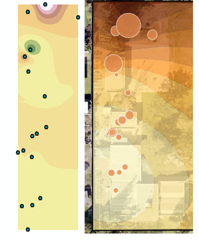
wondering if there is a way to have better results in the interpolating arcgisonline as I do with the IDW using Spatial Analysis .. the image below shows the interpolating using ArcGIS Spatial Analysis and on the right, the output from analysis interpolate arcgis online?
- Mark as New
- Bookmark
- Subscribe
- Mute
- Subscribe to RSS Feed
- Permalink
Warren... were the input parameters the same in terms of the conventional tool ?
Were the dataset both in projected coordinates? (they should be btw)
- Mark as New
- Bookmark
- Subscribe
- Mute
- Subscribe to RSS Feed
- Permalink
I'd have the points projected in local projection while online, I didnt think it would help .. I'll give it a try. The parameters are different only because their less, or perhaps simpler setting in AGOL
- Mark as New
- Bookmark
- Subscribe
- Mute
- Subscribe to RSS Feed
- Permalink
Yes...I get the point, It would be nice to do at least a comparison of one "thing" in two platforms and get the same result. I wouldn't even go to a Kriging demo when interpolation and its "bloody field" isn't the point you are trying to make on a small demo. It is a rare case where the method is specified in the help and in some cases, the algorithm isn't mentioned. Good luck
- Mark as New
- Bookmark
- Subscribe
- Mute
- Subscribe to RSS Feed
- Permalink
I couldn't find the link to the AGOL interpolate points tool method, but the similar (same?) tool through the ArcGIS REST API states that it uses empirical Bayesian kriging, which will produce different results than IDW:
Interpolate Points—ArcGIS REST API: Spatial Analysis Service | ArcGIS for Developers
As for how to force AGOL to do IDW, no clue.
- Mark as New
- Bookmark
- Subscribe
- Mute
- Subscribe to RSS Feed
- Permalink
The help inside the Interpolate ArcGIS Online, contains about the same information as found here in the documentation: Perform analysis—ArcGIS Online Help | ArcGIS . ... but doesn't reveal much about the method. I guess the links provided by Darren are best thing to go on, but I feel the documentation should shed some more light on the interpolation method used.
There are many ways to interpolate in ArcGIS for Desktop and some of them are described in this rather old document: http://www.esri.com/news/arcuser/0704/files/interpolating.pdf
- Mark as New
- Bookmark
- Subscribe
- Mute
- Subscribe to RSS Feed
- Permalink
If you want one button click to give you a "nice" picture, use AGOL.
If you want some control over the output and you know the data and what might be appropriate, use the tools in SA.
If you really want to spend a lot of time on the job, use GeoStat Analyst....
- Mark as New
- Bookmark
- Subscribe
- Mute
- Subscribe to RSS Feed
- Permalink
funny. I tell my students, if they want the best results they can go out and dig up the whole bloody field and no need to guess :-). But in the end .. I often have a class of only an hour of non GIS users ..and I may add 90% are Mac users.
- Mark as New
- Bookmark
- Subscribe
- Mute
- Subscribe to RSS Feed
- Permalink

Interpolation can be a really tricky thing. And it all depends on the data and the nature of the variable you are trying to interpolate and what sort out output you need and what it might be used for.
- Mark as New
- Bookmark
- Subscribe
- Mute
- Subscribe to RSS Feed
- Permalink
I just added feedback to the documentation on this analysis with a reference to this thread. Hopefully they will add some explanation.