- Home
- :
- All Communities
- :
- Products
- :
- ArcGIS Online
- :
- ArcGIS Online Questions
- :
- Re: Import TIFF (into webmap App) error
- Subscribe to RSS Feed
- Mark Topic as New
- Mark Topic as Read
- Float this Topic for Current User
- Bookmark
- Subscribe
- Mute
- Printer Friendly Page
Import TIFF (into webmap App) error
- Mark as New
- Bookmark
- Subscribe
- Mute
- Subscribe to RSS Feed
- Permalink
I am trying to import TIFF layer into my webmap. However, I am receiving an error that my layer cannot be added to my map. Below is a short description what I did:
1. My content > Add Item > From my computer > *.tif
2. *.tif > Share > Everyone
3. copy of *.tif URL
4. (My web map) > Add > Add Layer from Web > paste of URL > and here I always have an error that my layer cannot be added.
I would be grateful for some tips how to solve this issue.
- Mark as New
- Bookmark
- Subscribe
- Mute
- Subscribe to RSS Feed
- Permalink
Hi Karolina,
You will not be able to add the TIFF directly to a web map. If you navigate to the uploaded image and hover over OPEN, you will only have the option 'Download'.

You will need to create a ArcGIS Online tiled service or an ArcGIS Server Tiled/Dynamic/Image Service. Here is a helpful document that provides the steps to create an ArcGIS Online tiled service.
- Mark as New
- Bookmark
- Subscribe
- Mute
- Subscribe to RSS Feed
- Permalink
Hi Jake,
Thank you for detailed instruction. I tried to follow it, but I received an error for which I cannot find an answer. I generated tile cache, next I tried to apply Manage Tile Cache, and here I have an error. In the field "Import Tiling Scheme" I cannot choose my Tile Cache Tiling Scheme, I am receiving this error:
001480 : Data source spatial reference does not match tiling scheme spatial reference.
I checked this and the spatial reference is fine, so I do not know what is wrong. Do you have some ides how to skip this?
Thanks in advance.
- Mark as New
- Bookmark
- Subscribe
- Mute
- Subscribe to RSS Feed
- Permalink
What is the spatial reference you are trying to use to create the tile cache?
- Mark as New
- Bookmark
- Subscribe
- Mute
- Subscribe to RSS Feed
- Permalink
I am not specifying spatial reference. I am assuming that it is automatically taken from my input data, right? In my input data I have GCS_WGS_1984, and in my generated Tile cache Tiling Scheme I also have GCS_wGS_1984.
- Mark as New
- Bookmark
- Subscribe
- Mute
- Subscribe to RSS Feed
- Permalink
For the 'Input Data Source' within the Manage Tile Cache tool, are you specifying the TIFF image?
If so, can you send a screen shot of the coordinate system in the properties? Ex:

Can you also attach the tiling scheme file you created?
- Mark as New
- Bookmark
- Subscribe
- Mute
- Subscribe to RSS Feed
- Permalink
Yes, for the 'Input Data Source' within the Manage Tile Cache tool, I am specifying the TIFF image.
My TIFF file properties:
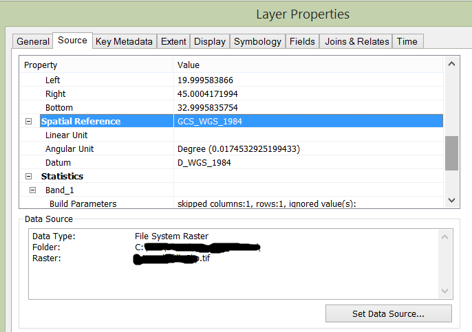
My Tile Cache Tiling Scheme:
<?xml version="1.0" encoding="utf-8" ?><CacheInfo xsi:type='typens:CacheInfo' xmlns:xsi='http://www.w3.org/2001/XMLSchema-instance' xmlns:xs='http://www.w3.org/2001/XMLSchema' xmlns:typens='http://www.esri.com/schemas/ArcGIS/10.3'><TileCacheInfo xsi:type='typens:TileCacheInfo'><SpatialReference xsi:type='typens:GeographicCoordinateSystem'><WKT>GEOGCS["GCS_WGS_1984",DATUM["D_WGS_1984",SPHEROID["WGS_1984",6378137.0,298.257223563]],PRIMEM["Greenwich",0.0],UNIT["Degree",0.0174532925199433],AUTHORITY["EPSG",4326]]</WKT><XOrigin>-400</XOrigin><YOrigin>-400</YOrigin><XYScale>11258999068426.238</XYScale><ZOrigin>-100000</ZOrigin><ZScale>10000</ZScale><MOrigin>-100000</MOrigin><MScale>10000</MScale><XYTolerance>8.983152841195215e-009</XYTolerance><ZTolerance>0.001</ZTolerance><MTolerance>0.001</MTolerance><HighPrecision>true</HighPrecision><LeftLongitude>-180</LeftLongitude><WKID>4326</WKID><LatestWKID>4326</LatestWKID></SpatialReference><TileOrigin xsi:type='typens:PointN'><X>-400</X><Y>400</Y></TileOrigin><TileCols>256</TileCols><TileRows>256</TileRows><DPI>96</DPI><PreciseDPI>96</PreciseDPI><LODInfos xsi:type='typens:ArrayOfLODInfo'><LODInfo xsi:type='typens:LODInfo'><LevelID>0</LevelID><Scale>250000000</Scale><Resolution>0.59486525145757008</Resolution></LODInfo><LODInfo xsi:type='typens:LODInfo'><LevelID>1</LevelID><Scale>125000000</Scale><Resolution>0.29743262572878504</Resolution></LODInfo><LODInfo xsi:type='typens:LODInfo'><LevelID>2</LevelID><Scale>64000000</Scale><Resolution>0.15228550437313793</Resolution></LODInfo><LODInfo xsi:type='typens:LODInfo'><LevelID>3</LevelID><Scale>32000000</Scale><Resolution>0.076142752186568963</Resolution></LODInfo><LODInfo xsi:type='typens:LODInfo'><LevelID>4</LevelID><Scale>16000000</Scale><Resolution>0.038071376093284481</Resolution></LODInfo><LODInfo xsi:type='typens:LODInfo'><LevelID>5</LevelID><Scale>8000000</Scale><Resolution>0.019035688046642241</Resolution></LODInfo><LODInfo xsi:type='typens:LODInfo'><LevelID>6</LevelID><Scale>4000000</Scale><Resolution>0.0095178440233211203</Resolution></LODInfo><LODInfo xsi:type='typens:LODInfo'><LevelID>7</LevelID><Scale>2000000</Scale><Resolution>0.0047589220116605602</Resolution></LODInfo><LODInfo xsi:type='typens:LODInfo'><LevelID>8</LevelID><Scale>1000000</Scale><Resolution>0.0023794610058302801</Resolution></LODInfo><LODInfo xsi:type='typens:LODInfo'><LevelID>9</LevelID><Scale>500000</Scale><Resolution>0.00118973050291514</Resolution></LODInfo><LODInfo xsi:type='typens:LODInfo'><LevelID>10</LevelID><Scale>250000</Scale><Resolution>0.00059486525145757002</Resolution></LODInfo></LODInfos></TileCacheInfo><TileImageInfo xsi:type='typens:TileImageInfo'><CacheTileFormat>MIXED</CacheTileFormat><CompressionQuality>75</CompressionQuality><Antialiasing>false</Antialiasing><BandCount>1</BandCount><LERCError>0</LERCError></TileImageInfo><CacheStorageInfo xsi:type='typens:CacheStorageInfo'><StorageFormat>esriMapCacheStorageModeCompact</StorageFormat><PacketSize>128</PacketSize></CacheStorageInfo></CacheInfo>
- Mark as New
- Bookmark
- Subscribe
- Mute
- Subscribe to RSS Feed
- Permalink
I re-installed my ArcGIS, and now problem with spatial reference does not occur. However, another error appeared:
001483 : Failed to write cache configuration to : <value>.
Make sure you have write permissions to the directory where the cache configuration is written.
I tried also to add my data in different way using "Share as service" - with a partly success. I was able to import my data into the map. However, I cannot check the pixel value of my raster layer. It is displayed as a graphic without the possibility to check the raster values.